All Activity
- Past hour
-
P solid and needed rainer
-
.thumb.jpg.6a4895b2a43f87359e4e7d04a6fa0d14.jpg)
Central PA Winter 25/26 Discussion and Obs
Yardstickgozinya replied to MAG5035's topic in Upstate New York/Pennsylvania
I was thinking about all the times that I posted pictures and given advice, about how well a slightly modified pitchfork works to remove Ice from paved surfaces going a way back to my Flatheadsickness days. I'm sure glad I didn't have to kill myself yesterday and I find it very satisfying watching that s*** peel right off effortlessly while others are breaking their back. -
Well, I looks like models have returned thankfully to their typical biases (instead of random solutions which make zero sense). Right now, I would roll with the deterministic Euro and GEM runs at 0z. Their progression makes sense, even if it a bit wonky. The 0z GEPS, 0z EPS, 6z AIFS Euro, and 6z AIGEFS ensembles general support the determinist Euro and GEM from 0z. Though I won't toss it...the GFS/GEFS combo is an outlier at this point. Overall, good trends overnight. We can have good winters even if the cold in Canada is AN but polar - if it is January. Plus, there is a lot of snowpack up there, and I have my doubts(GFS) if it gets scoured for long(if at all). Great disco overnight - read back prior to this post. Get that EPO ridge in place, and Siberian cold would possibly plunge into North America.
-
-
The distribution of the snowfall this month between ISP, PHI, and BOS is not what we typically see when Islip has a snowy 10”+ December. This is the first time since 1988 that ISP has 10”+ in December and either Philly or Boston doesn’t have at least 10” also. It’s why we may not be able to use the snowy December winter analogs that followed the other 10” December years on the list. This is due to the 10” at ISP being the first December with two 5”+ clippers that had narrower areas with heavy snow than benchmark coastal snowstorms that also affected Philly or Boston in the other snowy Decembers at Islip. So it will be interesting to see how the rest of the winter plays out at all three locations. All 10”+ snowy Decembers at ISP and the Boston and Philly snowfall 2009…ISP…25.3”….BOS….15.2”….PHI….24.1” 2002…ISP….16.0”….BOS….11.1”……PHI….8.4” 2003…ISP….15.5”…..BOS….21.5”….PHI….6.0” 2010….ISP….14.9”…..BOS…..22.0”…PHI…12.7” 1995….ISP…..13.3”…..BOS…..12.6”….PHI….7.3” 1969….ISP….12.0”…..BOS……12.6”….PHI….7.5” 2025….ISP….11.4”…..BOS…..2.3”……PHI….4.5” 1975…..ISP….11.4”…..BOS…..19.3”……PHI….7.5” 1963…..ISP…..11.0”….BOS….17.7”…….PHI….8.0” 2000….ISP…..10.8”….BOS….4.5”….…PHI…..10.5” 2008….ISP…..10.4”….BOS….25.3”…..PHI…..0.4” 1988…..ISP…..10.4”….BOS….3.7”……PHI…..0.4”
-
5/2 here, i'm 2 miles east of the river
-
Central PA Winter 25/26 Discussion and Obs
Yardstickgozinya replied to MAG5035's topic in Upstate New York/Pennsylvania
The less a fish bites, the more bait you gotta throw. Not everybody's an easy catch like your old neighbor here. Hopefully you didn't miss your little flizzards on the sixes yesterday. -
Heh. Woke up to a WWA in the southern tier of Wisconsin counties. Will happily take it!
-

Central PA Winter 25/26 Discussion and Obs
mahantango#1 replied to MAG5035's topic in Upstate New York/Pennsylvania
One thing I noticed last night after temps. dropped below freezing, the consistency of that sleet, freezing rain mixture on the ground changed. Yesterday during the afternoon you could walk on it not being slippy. Last night it turned to more of to pure smooth ice. Making it quite treacherous to even try to walk on. -
What a crazy torch! That Charlotte graphic above is mind boggling
-
Central PA Winter 25/26 Discussion and Obs
mahantango#1 replied to MAG5035's topic in Upstate New York/Pennsylvania
URGENT - WINTER WEATHER MESSAGE National Weather Service State College PA 221 AM EST Sun Dec 28 2025 PAZ006-012-045-049>053-058-282030- /O.EXA.KCTP.WW.Y.0028.251228T1800Z-251229T0600Z/ Potter-Northern Clinton-Southern Clinton-Union-Snyder-Montour- Northumberland-Columbia-Schuylkill- Including the cities of Shamokin, Sunbury, Berwick, Lewisburg, Danville, Bloomsburg, Pottsville, Renovo, Selinsgrove, Lock Haven, and Coudersport 221 AM EST Sun Dec 28 2025 ...WINTER WEATHER ADVISORY IN EFFECT FROM 1 PM THIS AFTERNOON TO 1 AM EST MONDAY... * WHAT...Freezing rain expected. Total ice accumulations up to one tenth of an inch possible. * WHERE...Potter, Northern Clinton, Southern Clinton, Union, Snyder, Northumberland, Montour, Columbia, and Schuylkill Counties. * WHEN...From 1 PM this afternoon to 1 AM EST Monday. * IMPACTS...Difficult travel conditions are possible. * ADDITIONAL DETAILS...Temperatures will gradually increase overnight tonight into Monday morning, ending the threat for freezing rain. PRECAUTIONARY/PREPAREDNESS ACTIONS... Be prepared for slippery roads. Slow down and use caution while driving. If you are going outside, watch your first few steps taken on stairs, sidewalks, and driveways. These surfaces could be icy and slippery, increasing your risk of a fall and injury. -

Central PA Winter 25/26 Discussion and Obs
Jns2183 replied to MAG5035's topic in Upstate New York/Pennsylvania
What is that even for? We are sitting at more than a 5 degree departure for the month and probably will end up closer to negative 6. Sent from my SM-S731U using Tapatalk -
Eps finally has us in the blue. 1 inch jump from yesterday
-

December 2025 regional war/obs/disco thread
Sugarloaf1989 replied to Torch Tiger's topic in New England
7F right now. A few degrees colder away from the Connecticut River on WU. I'm next to the river. - Today
-
Good post. Thanks.
-

Ice Ice Baby December 28-29 Storm Discussion
mahk_webstah replied to Baroclinic Zone's topic in New England
Couldn’t agree more. It will lock up the pack though. -
According to Mitch this might be the final tally j/k Mitch
-

Ice Ice Baby December 28-29 Storm Discussion
ineedsnow replied to Baroclinic Zone's topic in New England
Dew of -4 hopefully we can keep temps down later.. NAM kind of tame compared to the HRRR.. HRRR has a bunch.more qpf.. guess we see how this trends -

December 2025 regional war/obs/disco thread
moneypitmike replied to Torch Tiger's topic in New England
A balmy -2.7 this morning. Most will be basking in the 40's and 50's before long. -
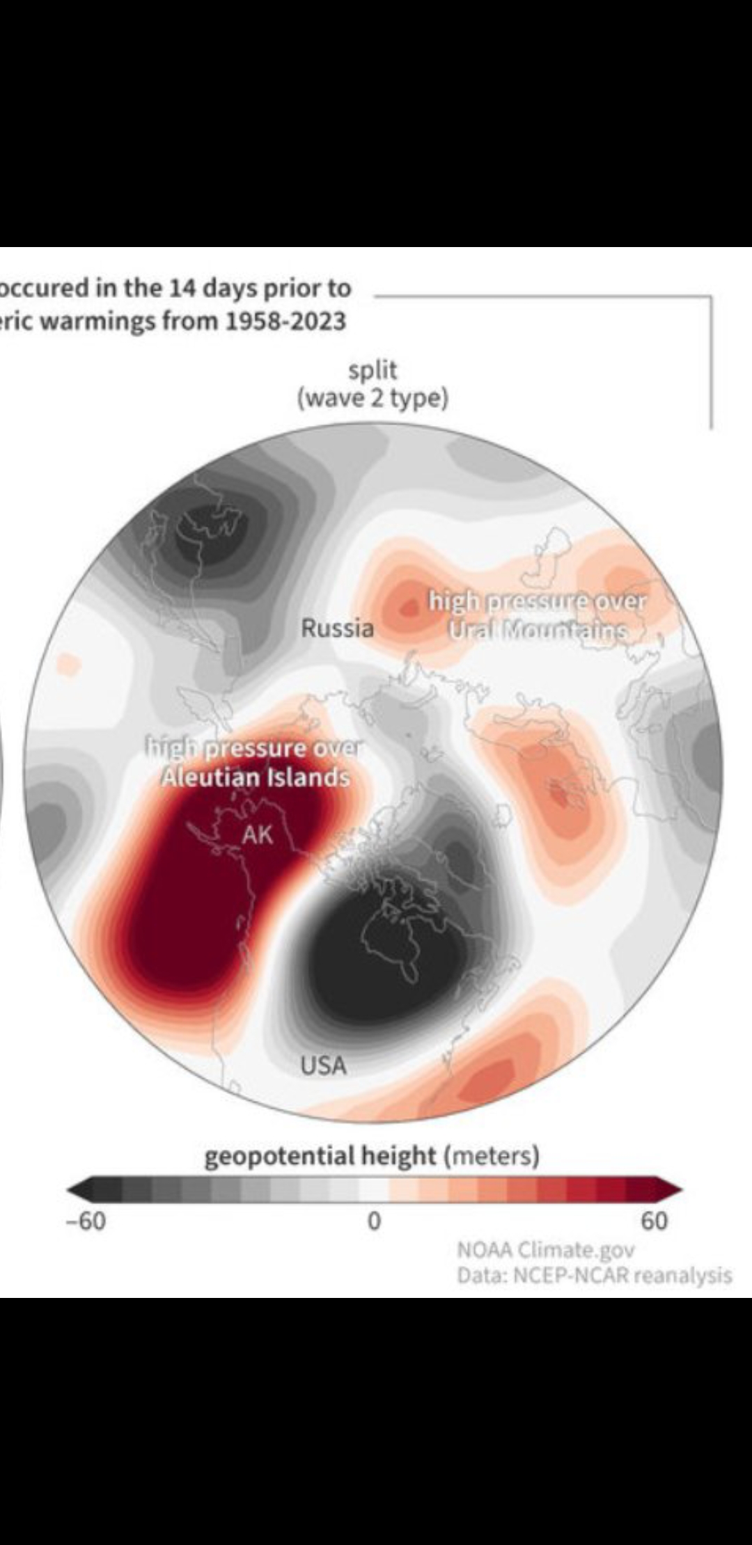
This winter is nothing like the other 2020's winters that everyone has PTSD from. Just look at how December has behaved. But don't only look at that. Look at how we're rolling forward into January now on the heels of that. Look at the big picture. It's true there is a stemwinder set to visit the great lakes region in the near term. There are blizzard warnings in the upper midwest stretching into the lakes. At the same time, there's blocking out in the Atlantic. It's been a long time since we've been faced with anything like what's going on. Reach back into your memory banks and recall that a stemwinder into the lakes, while there is blocking in the Atlantic, is the classic way to achieve a good old fashioned west based NAO block. Which is starting to become more clearly visible on the EPS now. While that's happening, the Pacific block which had been very persistent, is broken down due to a fortuitous Pacific jet extension. Which results in Aleutian troughing that forces a period of +PNA. Then even at the very end of this loop, look at what is happening. The Pacific pattern starts to retrograde. That is going to act to pull the +PNA ridging west and up into Alaska and beyond all of this we'll probably transition to a -EPO from there. Which you can start to make out on this loop with the height rises happening over Alaska, but also the falling heights in Canada and Hudson Bay. That would coincidently also be consistent with how weekly guidance is currently rolling all of this forward as well. Which, by the way, with this configuration if we did indeed follow that roadmap. We'd likely reload Canada with the arctic again. Plus we'd end up faced with a 500mb pattern which is the precursor to a PV split. Eyes wide open.

-
Got down to 8 this morning.. I see orange is -1 fake cold
-
One at hanscome Field and three at Norwood.
-
Six degrees on my car thermometer and it runs warm. FYI roads are pretty icy in spots.
-
Ice Ice Baby December 28-29 Storm Discussion
ineedsnow replied to Baroclinic Zone's topic in New England
I just hope we get some glaze on top of the snow before we warm -
6z Gfs (days 8-9) is a perfect example of a wasted block. But this run is so different from 0z, it's beyond entertainment and fantasy.