All Activity
- Past hour
-

Junorch obs and discussion 2026
TheClimateChanger replied to Damage In Tolland's topic in New England
For a certain segment of weather troll community, 95F and 70F dews is "just summer" and actual "just summer" weather is hyped up as the next coming of the year without a summer. -
Junorch obs and discussion 2026
TheClimateChanger replied to Damage In Tolland's topic in New England
Air conditioning makes a big difference too. We didn't have it back then and it was tough but bearable. You couldn't do that today in most places. -
Just a general thanks to all the red tagged and experienced members analysis of yesterday's storms. Lots of great information and education on severe storms for our area. It is a fun read.
- 590 replies
-
- 1
-

-
- severe
- thunderstorms
- (and 7 more)
-
thinking about the backyard snow people sitting there squinting at nino graphs looking for a tenth of a degree difference
-

Central PA Summer 2026 Discussion/Obs Thread
Jns2183 replied to Voyager's topic in Upstate New York/Pennsylvania
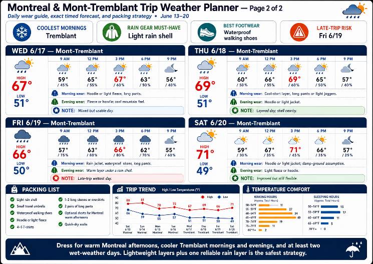
Heading up today to Montreal and Mont Tremblant, to apparently experience the April we never had here. And actually have to be faster days I will take that in the heart beat. After playing around with a bunch of different styles I think I've settled on this one for the perfect style for vacation weather sending out to everyone in the extended family who's going up there. Sent from my SM-S731U using Tapatalk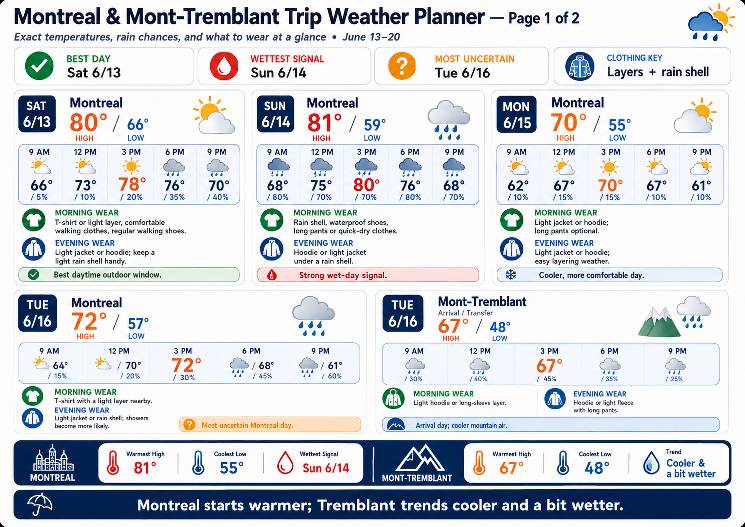
-
Interesting...and for some, unsettling-
-
Might just go to Brewster, NY today and hope to get lucky. Probably just go around 1 and wait there and then hopefully can make minor adjustments if needed but giving its a Friday and storm timing...traffic won't be fun
-
The 09z RRFS pops a decent cell over MoCo around 20z but it's pretty meh otherwise. Looks for sure like any threat might be focused S and E of DC.
-

Junorch obs and discussion 2026
TauntonBlizzard2013 replied to Damage In Tolland's topic in New England
More boos about the weather next week than Trump at MSG earlier this week? -
Central PA Summer 2026 Discussion/Obs Thread
Jns2183 replied to Voyager's topic in Upstate New York/Pennsylvania
It seemed like all the storms yesterday at issues reading inflow from the rain core and essentially would choke themselves while the area around them played roulette with who is going to get to convergence from the competing outflow boundaries and who was going to get left in the dust. If you look at what happens when the storms congeal consolidate into a cold pool that cold pool axis pretty much a shovel throwing up all the warm moist air quickly upwards and technically that is what propagating it they original storms pretty much blow up die off while the cold pool constantly is pushing the warm moisture ahead giving the illusion of the storms actually moving. Yeah there is definitely a gradient to all this. Sent from my SM-S731U using Tapatalk -
As was noted up thread maybe the slightly cooler temps will help generate some severe if not at least more garden variety storms?
-
Okay, glad I wasn't the only one as well thinking this. I was racing it home from Frederick and when I was coming over South Mountain you could see the storms pretty well, but getting close it was much less impressive looking. I think the storms took offense to that though, because they knocked out power for the second time in a week. Luckily this time only took the power company 3.5hrs to restore. Good winds, not too bad lightning, and some nice rain. I also am annoyed that due to the power outage I lost the data from my weather station for the storm. I guess I need to upgrade my station.
-
-
We're teeing off at 7:30 tomorrow morning. Not a big fan of Saturday morning early anything frankly ... buuut, fairways under sun you could swear you can hear sizzling makes even 82 F a bad golfing experience.
-
I come home bleeding from black flies and then the next day it’s all bug bites itching. It’s gotten real bad in these humid calm days. No breeze to knock the f*ckers back.
-
Today is the first day that I noticed any mosquitoes. I did start at 6:00 though to try to beat the heat so my comparisons to other days doesn't mean much.
-
Clean sweep: 611 Today's highs - hot in the city EWR: 97 PHL: 97 BLM: 97 TEB: 97 LGA: 96 ACY: 96 New Brnswck: 96 JFK: 95 TTN: 93 ISP: 92 NYC: 91
-
Agreed. I'm stopping short of asking that myself, tho, just because there's too much subjectivity to what summer "should be" to really wanna even engage in that futile endeavor, but personally? I think next week is 'seasonally bn' - for older schoolers, they know that means that yeah ... below normal but within seasonal reasonability so nothing obnoxious. The thing is, it's like there's multiple aspects concurrently true. The pattern verifies as a below normal +PNAP structure more than less, but we end up warmer than the pattern suggests we should - while still being lower that summers have been on sunny days going back 20 years worth of Gretta's ovulation cycles.
-

2026-2027 Super El Nino
snowman19 replied to Stormchaserchuck1's topic in Weather Forecasting and Discussion
@forkyfork I wonder what the models will show once this current WWB and the new DWKW that has formed does their “dirty work”? There is some major strengthening and warming about to come And once the +IOD gets going, it’s going to constructively interfere with the El Nino/Bjerknes feedback -
That dude was embedded within the line with 70-75 MPH straight line winds around it. Substantial damage caused by falling trees in Huntington, as well as the town of Andrews and Wabash, which are all located along US 24, basically the path that the radar indicated tornado took, from the town of Wabash to Ft. Wayne. I couldn't see anything from my house and wasn't going chase blind, but from radio traffic last night, if there was one on the ground, it went just north of town. NWS will be here this afternoon.
-
Records: Highs: EWR: 97 (2017) NYC: 93 (2017) LGA: 96 (2017) JFK: 92 (2017) Lows: EWR: 47 (1951) NYC: 48 (1979) LGA: 49 (1979) JFK: 49 (1980) Historical: 1881 - Severe thunderstorms spawned more than half a dozen tornadoes in the Lower Missouri Valley. Five of the tornadoes touched down near Saint Joseph MO. In south central Kansas a tornado nearly wiped out the town of Floral. Hail and high winds struck Iowa and southern Minnesota. In Minnesota, Blue Earth City reported five inches of rain in one hour. (David Ludlum) 1885: A tornado in Iowa blew part of a train off the tracks, injuring three passengers. Three coaches and a baggage car were lifted into the air and onto a field. (Ref. Wilson Wx. History) 1899: New Richmond, Wisconsin: A killer tornado rampages through New Richmond, Wisconsin, 114 people die, many attending an outdoor circus. 1915: An estimated F4 tornado moved northeast from northwest of Waterville, Iowa crossing the Mississippi River two miles south of Ferryville, Wisconsin. A man and his daughter were killed in one of three homes that were obliterated southwest of "Heytman," a small railroad station on the Mississippi River. 60 buildings and eight homes were destroyed in Wisconsin. This tornado caused approximately $200,000 in damage. In addition to this tornado, another estimated F4 tornado moved northeast across Fayette and Clayton Counties in northeast Iowa. One farm was devastated, the house and barn leveled. Heavy machinery was thrown 300 yards. Clothing was carried two miles. 1918: Victorville, CA recorded their highest temperature for June at 114°. This was also their second highest temperature ever (116° - 7/10/2002). This was followed be their warmest night on record with a low of 88°. (Ref. Wilson Wx. History) 1947 - A heavy wet snow blanketed much of southern and central Wyoming, and gave many places their heaviest and latest snow of record. Totals included 18.4 inches at Lander, 8.7 inches at Cheyenne, and 4.5 inches at Casper. (11th-12th) (The Weather Channel) 1948: The Columbia River Basin flood peaked on this date in the Northwest. The flood produced the highest water level in the basin since the flood there in 1894. The damage estimate for the 1948 flood was $101 million, and 75 lives were lost. 1956: The upper Midwest was in the midst of a six-day stretch of 90 degree plus temperatures. The high of 97° at Chicago, IL and 95° at Rockford, IL set daily high temperature records. (Ref. Wilson Wx. History) 1959: A heavy thunderstorm was accompanied by a small tornado at Celeron near Jamestown, NY and gave a two inch rainfall in 75 minutes in Colden, NY. (Ref. Wilson Wx. History) 1968: Tropical Storm Abby moved northeast and crossed central Florida, briefly reaching hurricane status in the Gulf of Mexico. The tropical storm then moved along the coast of Florida and into Georgia, then made a loop as a tropical depression through the Carolinas, moving south to the North Carolina/South Carolina coast. Locations that received record daily rainfalls included: Philadelphia, PA: 3.05 inches, Reagan National Airport in Washington, DC : 2.23 inches, Dulles Airport at Sterling, VA: 1.88 inches, Wilmington, DE: 1.75 inches, Newark, NJ: 1.74 inches and Williamsport, PA: 1.30 inches. (Ref. Wilson Wx. History) 1969 - Record late season snows covered parts of Montana. Five inches was reported at Great Falls and east of Broadus. Billings, MT, tied their June record with lows of 32 degrees on the 12th and the 13th. (The Weather Channel) 1978: Lightning killed a 14 year old boy running home to avoid the rain at Lauderhill, FL. The lightning struck a pine tree near the boy and severely burned his legs and knocked his shoes off. (Ref. Wilson Wx. History) 1983 - The state of Utah was beseiged by floods and mudslides. Streets in downtown Salt Lake City were sandbagged and turned into rivers of relief. The town of Thistle was completely inundated as a mudslide made a natural dam. (The Weather Channel) 1987 - Thunderstorms in Nebraska produced softball size hail around Fremont and Ames, and 3.5 inches of rain in less than one hour. Four and a half inches in less than an hour caused flooding around Ithica, NE. A tornado destroyed a mobile home near Broken Bow, NE, injuring both occupants. (The National Weather Summary) (Storm Data) 1988 - Fifteen cities in the southeastern U.S. reported record low temperatures for the date, including Asheville with a reading of 40 degrees. Drought conditions continued to intensify across the eastern half of the nation. Rainfall at Nashville, TN, was running 12.5 inches below normal. (The National Weather Summary) 1989 - Thunderstorms produced severe weather from Tennessee Valley to the Central Appalachians in the afternoon and evening, and produced severe weather in Oklahoma and Texas during the evening and night. Thunderstorms spawned ten tornadoes, and there were 164 reports of large hail and damaging winds. Thunderstorms produced wind gusts to 100 mph at Amarillo, TX, and wind gusts to 110 mph at Denton TX. Hail three inches in diameter was reported at Tucumcari NM. (The National Weather Summary) (Storm Data) 1994: Dickinson County was hard hit when 60 to 80 mph winds struck throwing a sail boat into a tree along the Spirit Lake shoreline. Reports from around Emmet, Dickinson and Clay Counties indicated rainfall amounts from 2 to as much as 6 inches within a two hour period. Flash flooding was also reported in Lyon County where an incredible three inches of rain fell in a 30 minute period in the town of George. A tornado formed in Plymouth County and moved through the town of Le Mars, causing about $3 million dollars in damage. Approximately 120 buildings were damaged with 2 x 6 boards driven through neighboring houses. The tornado picked up a dog house with the dog still inside. The dog house was deposited a few blocks away, upside down, with the dog still inside. The dog was not injured. Hail destroyed 70,000 acres of cropland across South Dakota. In Hand County, South Dakota, a thunderstorm caused an estimated $3 million dollars in crop damage. Hail, the largest being baseball size, was reported in drifts of three to four feet high. About 70 thousand acres of cropland and pastures were completely destroyed. Pheasants and ducks were killed by the hail and many cattle injured. Many windows were broken in homes, holes were punched in mobile homes, damaged occurred to contents of homes from hail which entered through windows, and many vehicles were extensively damaged. (Ref. Wilson Wx. History) 2002: (Kearney, Nebraska area): Hailstorm caused $2 million in agricultural losses. More than 22,000 acres of corn, soybeans and alfalfa were severely damaged or destroyed. (Ref. Hail Events by Michael Mogil) A supercell thunderstorm dumped copious amount of large hail across Buffalo and Kearney Counties in Nebraska. Hail up to 5 inches in diameter fell, injuring 15 people, and doing $100 million in damages. In excess of 6,000 structures sustained damage. In some cases, hailstones penetrated shingles, sheeting, and interior ceiling drywall. One person reported an 8 inch diameter hole in their roof. Another person reported hailstones landing on the living room couch after falling through the roof.(Ref. Wilson Wx. History) 2005 - A tornado in Hammond, Wisconsin damaged 22 homes and produced $3.6 million in damage (Associated Press).
-
Oh I'm sure it's in the mail. Probably what happens is you'll get that population overtaxing and die off around your region over the next month. Things get better into July while we "wake" up down here. Just delayed. There's always at least 2 or 3 week window where if seems like we left open all the windows, just a matter of when.
-
79 / 71 partly cloudy here a bit more cloudy north. Hay - Hot - humid low - mid/upper 90s tody. More storm chances. A bit drier / cooler Sat / Sun upper 80s to low/mid 90s i the hottest locations. 6/15 - 6/17 cooler, warm back up by the 18th and overall warmer beyond there by way of mix of some near normal - below and shorter intervals of heat. Ahead of next month next heat surge.
-
Ah,... yeah, I guess. I typically just use temperature. DP around here - for me - is always iffy. Seems odd maybe to think that with an actual ocean sitting there, but we are at a non-fixed confluence of a dry vs wet streams. It seems we spend about equal time either in a continental arid Canadian delivery ( even over the top heat is sometimes coughing dry), or... we get a mash up of Dallas to Chicago industrial flatulence mixed with southern bio-mist. Every once in a rare while we'll get a real pure DP air via the Bahama transport - some of the bluest sky on the planet actually occurs when the DP is 78 F that way. Anyway, that split between massive DP sweats to then huge DP sweeps, probably on average ever 2 or 3 days doesn't fix my nostalgia either way. It also seems era bias too. I swear we had more dewy summers back in the 1980s. That's when I moved to Rockport Ma/Cape Ann's arty culture's bizarre marriage with lobster merchants pushing wakes across the harbor by their two stroke diesel engines leaving a trail of black smoke ... I guess the artist paint how the lobster men feed them. Weird cultural shock that year. Sometime later in the 1990s we started getting hotter and drier summers, excluding any outliers like that 2000 oddity. The last 25 years have been variable but undeniably warming across that total variability. But one peculiar behavior I've noticed: a tendency to split the warm heights and warm thickness ( non-hydrostatic height vs hydrostatic height). I keep seeing in summer where the non hydrostatic heights might balloon to 585+ clear to Montreal, yet the 572 dm hydrostatic thickness along with higher DPs curves/dives S of here. Not this week of course. ha
- Today
-

2026 Mid-Atlantic Severe Storm General Discussion
batmanbrad replied to Kmlwx's topic in Mid Atlantic
SPC did keep the 30 wind area in their 9AM update, but did shift it a bit E/SE, otherwise few changes - as you say, we'll see if anything improves on the CAMs otherwise many of us may (again) be disappointed.