All Activity
- Past hour
-
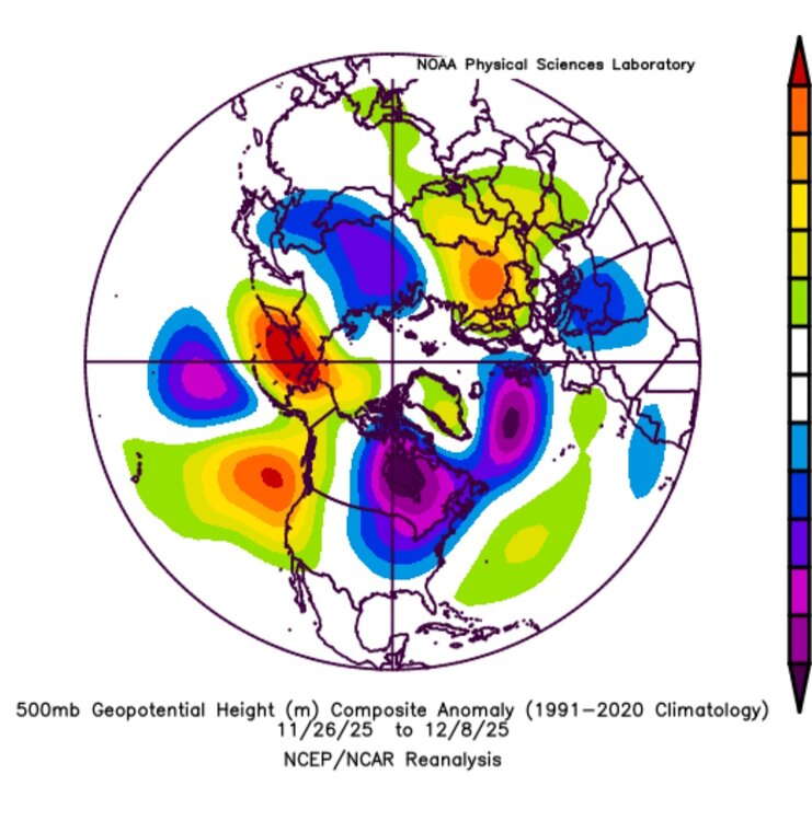
Somehow always flips around Christmas and then finally full flips back to a favorable pattern in March
-

12/14: Sunday funday? Will the south win again?
NorthArlington101 replied to TSSN+'s topic in Mid Atlantic
No way to know what's correct right now. Sure we all have our preferences - and we're all still in the game. Fingers crossed for an outcome that benefits as many folks as possible. -

December 2025 regional war/obs/disco thread
weatherwiz replied to Torch Tiger's topic in New England
This deserves post of the year -

Central PA Winter 25/26 Discussion and Obs
mahantango#1 replied to MAG5035's topic in Upstate New York/Pennsylvania
I know some people criticize that model, but other ones have problems too. But maybe we should ride the NAM till the wheels fall off. -
Makes perfect sense since they both ended up in the Mid-Atlantic!
-
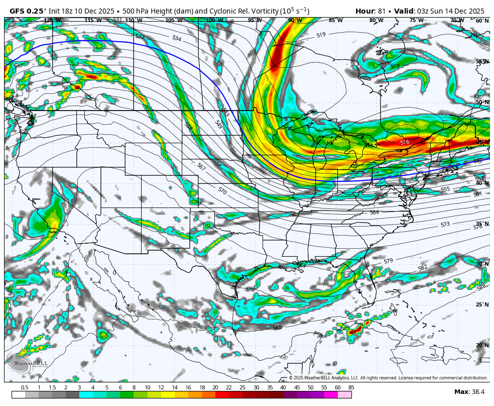
NOV 26 colder started in phase 6 headed into phase 7 & then into phase 8 through DEC 6. Here is the pattern NOV26-DEC 8 It appears the MJO did indeed influence the pattern....pretty strongly.
-
Totals for VT ...Vermont... ...Addison County... Starksboro 4.4 ENE 2.7 in 0900 AM 12/11 44.24N/72.97W Bristol 2.2 in 0645 AM 12/11 44.14N/73.09W/533 Shoreham 3.5 NNE 2.0 in 0800 AM 12/11 43.94N/73.28W/275 Vergennes 1.4 in 0430 AM 12/11 44.17N/73.25W/194 ...Bennington County... 5 NNW Londonderry 12.0 in 0710 AM 12/11 5 S Woodford State Park 7.8 in 1029 PM 12/10 Public Stamford 5.0 NNE 3.6 in 0400 PM 12/10 COCORAHS ...Caledonia County... Wheelock 1.6 S 5.4 in 0600 AM 12/11 44.56N/72.09W/1158 Sutton 5.3 in 0821 AM 12/11 44.61N/72.05W/1500 Wells River 2.1 WNW 5.0 in 0656 AM 12/11 44.23N/72.11W/1206 2 NE East Lyndon 5.0 in 0700 AM 12/11 44.54N/71.94W West Burke 5.0 in 0728 AM 12/11 44.64N/71.98W Danville 0.4 N 4.0 in 0700 AM 12/11 44.42N/72.14W/1406 St. Johnsbury 0.4 N 3.2 in 0730 AM 12/11 44.42N/72.02W ...Chittenden County... Underhill 5.1 NNE 5.1 in 0630 AM 12/11 44.60N/72.92W/908 2 NNE Underhill 4.0 in 0822 AM 12/11 44.55N/72.93W/1000 Underhill 3.6 ESE 3.5 in 0740 AM 12/11 44.50N/72.88W Williston 0.2 WSW 3.0 in 0700 AM 12/11 44.44N/73.07W/518 Nashville 1 E 2.9 in 0645 AM 12/11 44.45N/72.93W/825 Huntington 1.1 E 2.8 in 0700 AM 12/11 44.32N/72.97W/991 Huntington 6.5 S 2.8 in 0800 AM 12/11 44.23N/72.96W/1096 Hinesburg 0.9 N 2.8 in 0854 AM 12/11 44.34N/73.11W/519 Hinesburg 1.5 SW 2.2 in 0700 AM 12/11 44.32N/73.14W/435 Shelburne 0.5 ENE 1.7 in 0700 AM 12/11 44.38N/73.22W South Burlington 2.6 SSW 1.7 in 0800 AM 12/11 44.42N/73.19W South Burlington 2.4 NNE 1.5 in 0908 AM 12/11 44.49N/73.16W Burlington 3.8 NW 0.8 in 0800 AM 12/11 44.52N/73.26W/177 ...Essex County... 1 NW Maidstone State Park 8.5 in 0906 AM 12/11 44.66N/71.65W Lunenburg 2.3 NNW 5.0 in 0500 AM 12/11 44.49N/71.70W/1472 Island Pond 4.0 in 0932 AM 12/11 44.81N/71.89W/1200 ...Franklin County... Enosburg Falls 2.5 N 5.9 in 0730 AM 12/11 44.94N/72.80W Montgomery 4.1 ESE 5.0 in 0700 AM 12/11 44.88N/72.56W/1005 Swanton 0.5 NNE 3.3 in 0700 AM 12/11 44.93N/73.12W/139 ...Lamoille County... Morrisville 7.3 in 0726 AM 12/11 44.56N/72.60W Johnson 2 N 6.0 in 0730 AM 12/11 44.66N/72.68W/980 Stowe 0.2 SW 5.7 in 0730 AM 12/11 44.46N/72.69W/731 Jeffersonville 1.3 SSW 5.2 in 0700 AM 12/11 44.63N/72.84W/804 2.5 N Smugglers Notch 5.1 in 0730 AM 12/11 44.58N/72.79W/1163 Cambridge 5.0 in 0918 AM 12/11 44.65N/72.88W ...Orange County... Randolph 7.5 in 1031 PM 12/10 43.92N/72.67W Braintree 2.8 SW 4.1 in 0700 AM 12/11 43.94N/72.75W/1610 Bradford 2.2 NNW 3.8 in 0530 AM 12/11 44.02N/72.15W/1124 1.5 E Corinth Corners 3.7 in 0650 AM 12/11 44.01N/72.32W/1180 2 SE Strafford 3.2 in 0630 AM 12/11 43.83N/72.36W Williamstown 3.0 WSW 2.4 in 0700 AM 12/11 44.11N/72.60W/1565 ...Orleans County... Westfield 0.8 WNW 8.5 in 0730 AM 12/11 44.89N/72.44W/1068 1 WNW Albany 6.5 in 0736 AM 12/11 44.74N/72.40W Craftsbury Common 6.2 in 0700 AM 12/11 44.66N/72.39W Greensboro 3.9 NNE 6.0 in 0730 AM 12/11 44.63N/72.28W/2035 Morgan 6.7 SE 5.5 in 0645 AM 12/11 44.86N/71.91W/1341 2 NNE Albany Center 5.3 in 0855 AM 12/11 44.76N/72.33W 2 N Greensboro 5.2 in 0948 AM 12/11 44.61N/72.29W Derby Line 1.9 W 5.1 in 0700 AM 12/11 45.00N/72.14W/771 Greensboro 2.1 NNW 5.1 in 0700 AM 12/11 44.61N/72.31W/1495 Brownington 4.7 ESE 4.7 in 0800 AM 12/11 44.81N/72.08W/1467 ...Rutland County... West Rutland 0.9 SSE 5.5 in 0800 AM 12/11 43.58N/73.04W/545 2 NE Hortonia 5.0 in 0400 PM 12/10 43.76N/73.20W 1 N Rutland 4.6 in 0700 AM 12/11 43.63N/72.98W/620 Rutland 1.2 N 4.6 in 0700 AM 12/11 43.63N/72.98W/629 Shrewsbury 0.8 W 4.5 in 0600 AM 12/11 43.51N/72.88W Pittsford 2.2 SSE 4.5 in 0730 AM 12/11 43.68N/73.02W Wallingford 2.7 SSW 3.6 in 0700 AM 12/11 43.43N/72.99W/602 ...Washington County... 3 SSW Waterbury 8.7 in 0445 PM 12/10 44.30N/72.78W Waterbury 3.0 NW 7.1 in 0600 AM 12/11 44.36N/72.81W/458 Woodbury 3.4 NNW 6.5 in 0700 AM 12/11 44.49N/72.43W/1624 1.6 W Worcester 6.0 in 0700 AM 12/11 44.37N/72.58W/1360 East Calais 1.5 SW 5.5 in 0700 AM 12/11 44.36N/72.46W/1054 Northfield 1.5 N 3.8 in 0700 AM 12/11 44.17N/72.65W/672 East Montpelier 3.5 in 0730 AM 12/11 44.27N/72.50W Montpelier 1.7 NE 3.0 in 0800 AM 12/11 44.28N/72.55W Warren 2.8 E 2.8 in 0700 AM 12/11 44.11N/72.80W ...Windsor County... Andover 2.5 NW 7.5 in 0700 AM 12/11 43.30N/72.74W/1766 Ludlow 3.4 S 6.8 in 0700 AM 12/11 43.35N/72.70W/1727 3 S Ludlow 6.5 in 0830 PM 12/10 43.35N/72.70W Proctorsville 0.3 NNE 6.4 in 0700 AM 12/11 43.39N/72.64W/983 Chester 4.1 WNW 6.1 in 0800 AM 12/11 43.27N/72.67W Hartland 4.1 W 5.5 in 0800 AM 12/11 43.53N/72.48W/1140 Chester 3.0 WSW 5.2 in 0700 AM 12/11 43.24N/72.65W/1097 Barnard 2.7 NW 4.5 in 0700 AM 12/11 43.75N/72.66W 3 NW Barnard 4.5 in 0716 AM 12/11 43.76N/72.66W Rochester 1.7 NNE 3.6 in 0500 AM 12/11 43.90N/72.80W 0.6 E Woodstock 3.6 in 0800 AM 12/11 43.63N/72.51W/600 North Hartland 1 NNE 3.0 in 0700 AM 12/11 43.60N/72.36W/562
-
Gfs hung on the longest with 4" in the first threat here and finally caved at the end.
-

Minor snow possible sunday 12/14/25
LoboLeader1 replied to WeatherGeek2025's topic in New York City Metro
We need a negative tilted trough. -
Eastern Loudoun here. Perhaps a coating if lucky
-
Yep, there's always payback! Hopefully there won't be that much payback for all the cold we've seen for the past few weeks...
-
i can hear a certain poster at 990' elevation in Tolland smashing his laptop right now.
-

12/14: Sunday funday? Will the south win again?
midatlanticweather replied to TSSN+'s topic in Mid Atlantic
I am out here in Western Loudoun. It is not looking great. I am betting on fail. -
-

December 2025 regional war/obs/disco thread
Torch Tiger replied to Torch Tiger's topic in New England
-

Minor snow possible sunday 12/14/25
MJO812 replied to WeatherGeek2025's topic in New York City Metro
Gfs is slowly getting there -
I can give you Breslow's reasoning for not doing anything as its the same year in and year out.
-
A few re-edits and new shots from the other night and following morning:
-
(002).thumb.png.6e3d9d46bca5fe41aab7a74871dd8af8.png)
E PA/NJ/DE Winter 2025-26 Obs/Discussion
ChescoWx replied to LVblizzard's topic in Philadelphia Region
GFS did move north a bit from it's 6z run...but still south of some of the other models.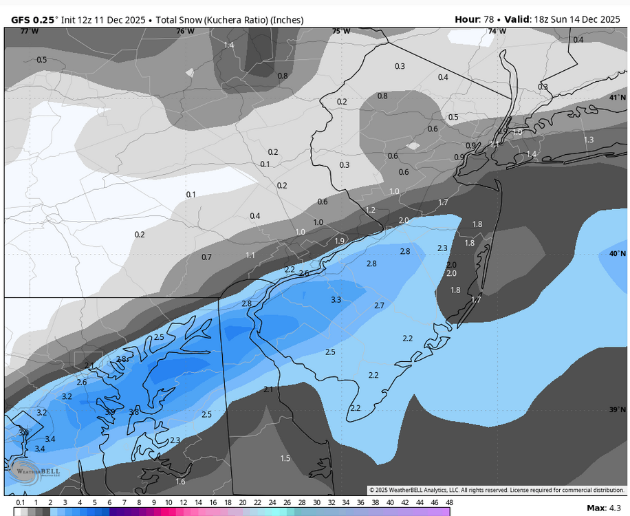
-

December 2025 regional war/obs/disco thread
Sey-Mour Snow replied to Torch Tiger's topic in New England
Tick tick tick
-
I’d like to know what snow gods we pissed off. It feels like we are going for the golden sombero at this pace.
-
That's the worst penis i have ever seen.
-
Seems like we got NAM/Rgem the most north, gfs the most south and euro and icon in between
-

December 2025 regional war/obs/disco thread
40/70 Benchmark replied to Torch Tiger's topic in New England
Is the GFS as interested in SNE snow as the Sox were in Alonso? -
The few events we've had favored areas that cash in on a NW wind direction. The Bentleyville/Solon area seems to be ground zero. Payback for all the events that have a due westerly wind we miss out on