All Activity
- Past hour
-

December 2025 Short/Medium Range Forecast Thread
jaxjagman replied to John1122's topic in Tennessee Valley
Just to edit the pic above ill post it here,wasnt aware i cut the dates out
-
Forecast has clouds increasing. If that happens won't be a cold night.
-
December 2025 Short/Medium Range Forecast Thread
jaxjagman replied to John1122's topic in Tennessee Valley
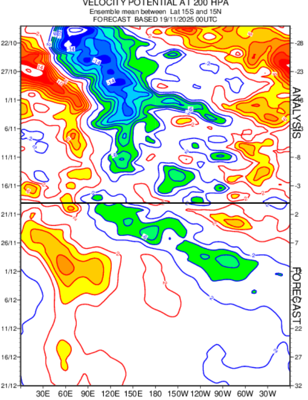
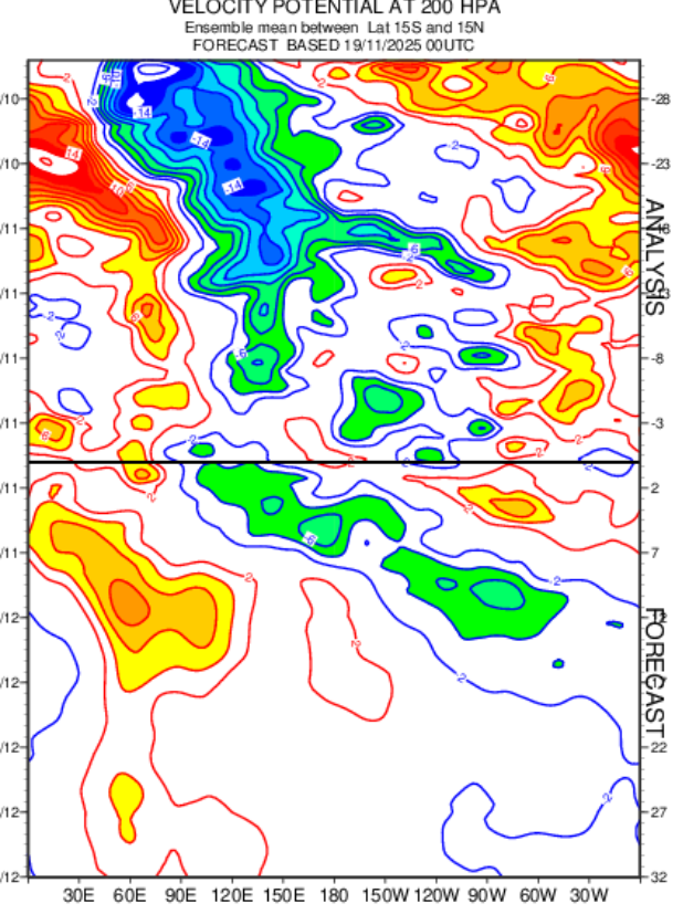
Typically Dec in Mid/Tn is the wettest month of the year,its even wetter in West Tn into the Ozarks. Take these maps with a grain of this far out,probably from Rossby,Kelvin Waves,,but at least the Euro is showing something similar,but once again a grain of salt this far out
- Yesterday
-

December 2025 Short/Medium Range Forecast Thread
Daniel Boone replied to John1122's topic in Tennessee Valley
Good work and analysis man ! I'm right with you on your thoughts regarding the Cold Shots as well buddy. -
32 already. Cold night incoming?
-
December 2025 Short/Medium Range Forecast Thread
Daniel Boone replied to John1122's topic in Tennessee Valley
Yep..I.m at 1.6" . Some Locations in Western Lee County in the Valley are at 4 inches. -
this would be pretty amazing in person. some snow showers in the mountains
-
What a miserable person. Sad.

-
He will continue to get beat up as the pocket compresses/collapses due to poor OL play. Terrible job by EDC and also Harbaugh who refuses to explore other options at guard. Again, Hello Ben Cleveland?- a dude Harbaugh was so fired up over and wanted to trade up to get if necessary 5 years ago on draft day. He rots on the bench and remains in the doghouse because Harbaugh doesnt like how he practices. So we continue to see the Faalele embarrassment week after week. Vorhees is almost as bad.
-

Pittsburgh PA Fall 2025 Thread
ChalkHillSnowNut replied to TheClimateChanger's topic in Upstate New York/Pennsylvania
This literally made my day in all ways!! -

November 2025 general discussions and probable topic derailings ...
H2Otown_WX replied to Typhoon Tip's topic in New England
Do you think there could be a wave spacing issue given the signal for something in the Tuesday/Wednesday timeframe next week? I guess that should be enough to let Saturday do its thing but it's a little close I'd say. Will probably come down to what that midweek piece of energy does. -
Last year's model trend was to dry everything out as the event got closer. Seems like that hasn't changed.
-
I’m eyeing it only because UVA has a date with destiny that Saturday. Snow game would be amazing but unlikely. Cold rain game would suck. Kinda hoping it just poofs.
-
-
100% chance of weather!
-

November 2025 general discussions and probable topic derailings ...
Typhoon Tip replied to Typhoon Tip's topic in New England
It's more the 29th ... but yeah. It's too low confidence to know about track and amplitude - the latter's probably too strong in this run though. Might be the first multi-region/full synoptic event of the season; don't need it to be heading for the 980s in order to do it. This is open wave NJ model low. They can bomb so we can't through the idea away entirely, but given to the progressive nature ... a middling system fits better.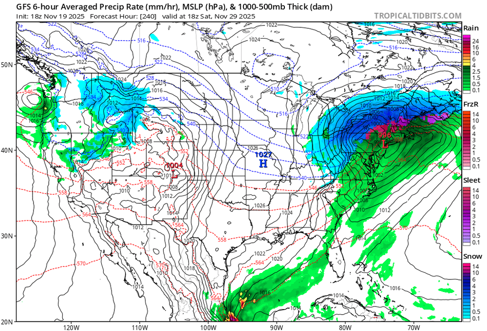
-
I wasn’t talking about on here you bozo. Did you even bother to read what I said or you just saw that I dared to say “not extreme cold” and you saw red. Oh wait…..you never see red
-

November 2025 general discussions and probable topic derailings ...
WinterWolf replied to Typhoon Tip's topic in New England
Good place for it at 11days out…if its even real. -
Friday evening, I'll start the Dec thread due to already discussed Stratwarm and its impact as a pattern changer-plunger in North America. That way I can add the CPC week 3-4 outlook and any D8-14 hazards which I suspect will be developing in the east, beyond lake effect.
-
 AIF’s are cold and dry for that . OTS
 -
I saw that this AM. I figured they hadn't even started making snow. I think I heard they plan to have the new summit lift online by December 8. I guess that took pressure off making snow to summit.
-

2025-2026 ENSO
brooklynwx99 replied to 40/70 Benchmark's topic in Weather Forecasting and Discussion
honest question, why are you even on twitter? I avoid twitter like the plague there are enough knowledgeable people here -

November 2025 general discussions and probable topic derailings ...
MJO812 replied to Typhoon Tip's topic in New England
Big interior snowstorm -

November 2025 general discussions and probable topic derailings ...
leo2000 replied to Typhoon Tip's topic in New England
Different answer on Google search ai answer says as few days to a couple of weeks for a major SSW to be felt in the mid latitudes such as North America and eastern Canada. With the effects potentially lasting up to two months. Regardless, there comes a risk with this as we could end up getting a suppressed storm track depends on where the SPV sets up right over Hudson Bay is ideal. -
November 2025 general discussions and probable topic derailings ...
WinterWolf replied to Typhoon Tip's topic in New England
Ya, I’m real cool with that, was just making a point. Carry on.