All Activity
- Past hour
-

Rise of the Machines: January 18-19 Winter Storm Obs Thread
moneypitmike replied to WxWatcher007's topic in New England
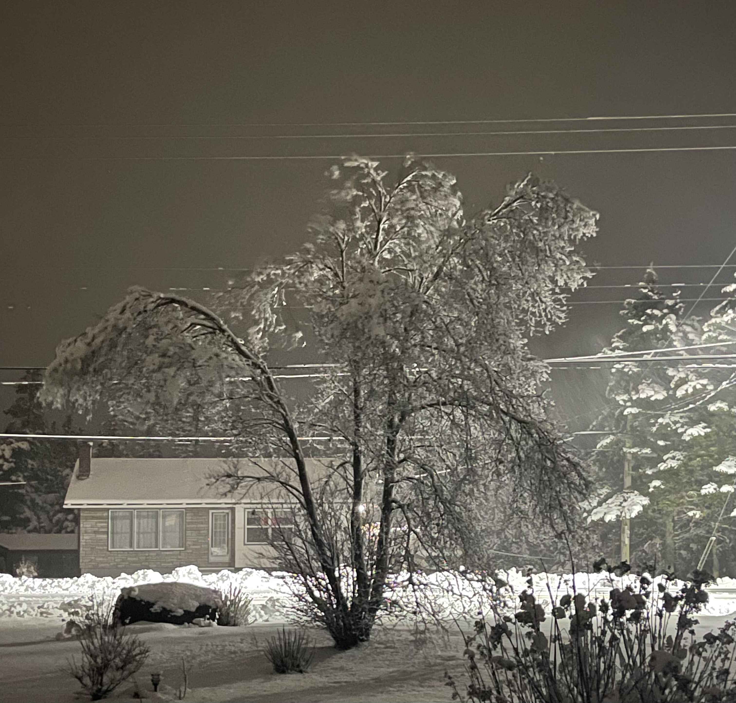
Looks like a solid 4" on the deck here in PVD. Everything nicely plastered. -

2025-2026 Fall/Winter Mountain Thread
ncjoaquin replied to Buckethead's topic in Southeastern States
Surprisingly, down to 14.4 this morning so far. Really bottomed out. I will believe any snow forecasts when I am shoveling the result. I am hoping for no ice, and hoping the models are right for a change. -

Rise of the Machines: January 18-19 Winter Storm Obs Thread
weatherwiz replied to WxWatcher007's topic in New England
About 2.5” here from evening/overnight. 6.5” between the 2 days -

January 2026 Short/Medium Range Thread
fountainguy97 replied to John1122's topic in Tennessee Valley
Overnight ensembles are juicy. Lots to be ironed out but you can clearly see the classic CAD boundaries setting up. Hopefully the zr outputs end up being a lot of sleet. the NBM shows the footprint well.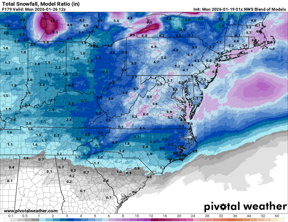
-
6z GEFS is a Big One. Especially just north from where the ICE line is.
-
Got down to 8
-
January 2026 regional war/obs/disco thread
moneypitmike replied to Baroclinic Zone's topic in New England
Thanks for this, Ray. Very educational--good luck with the call. Actually, I hope your call of the first system likely to be suppressed is off and we get clobbered. -
I like our position after the morning runs significantly more than before them last night. Seeing the Euro and Euro Ai together with positive steps from the CMC and GFS is very good.
-
More like 48 hours before.
-

January 25/26 Jimbo Back Surgery Storm
WinstonSalemArlington replied to Jimbo!'s topic in Southeastern States
-

Rise of the Machines: January 18-19 Winter Storm Obs Thread
Modfan2 replied to WxWatcher007's topic in New England
Out working in RI in the Exeter/North Kingston area and eye balling 5-7” of heavy wet snow @The 4 Seasons5” in Brooklyn, 4” last night and 1” from the am; nothing on Saturday -

Rise of the Machines: January 18-19 Winter Storm Obs Thread
The 4 Seasons replied to WxWatcher007's topic in New England
After all that whining and complaining and calling the storm off completely, he pulls a near warning event you feelin better yet? cuz we aint done yet -
EPS came slightly south. In a good spot overall, with ice being the primary limiting factor for a higher end event for now.
-
January 2026 regional war/obs/disco thread
moneypitmike replied to Baroclinic Zone's topic in New England
A run for James. -

E PA/NJ/DE Winter 2025-26 Obs/Discussion
Duca892 replied to LVblizzard's topic in Philadelphia Region
Squash city again on GFS. Le sigh -
Finished with 0.72” yesterday which was a nice surprise given the severe drought we are now in
-

Winter 2025-26 Medium/Long Range Discussion
A-L-E-K replied to michsnowfreak's topic in Lakes/Ohio Valley
Looks like pure zzzzs after the midweek duster -

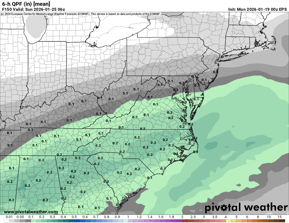
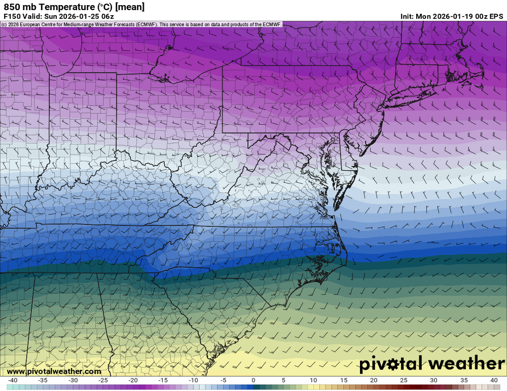
January 2026 Medium/Long Range Discussion
Stormchaserchuck1 replied to snowfan's topic in Mid Atlantic
6z GFS almost has a 50/50 low.. We have a strong composite in our biggest snowstorms for DC/Balt for negative 500mb anomalies in the 3 areas I marked with a black line. In the last few days it's come a little closer. We need that Great Lakes trough to trend south or SW. -
That's one heck of an ice storm for the whole southern states
-
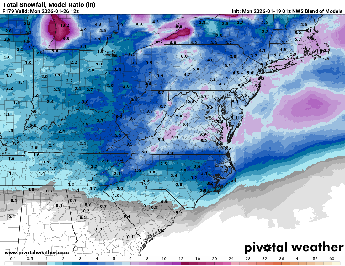
Magnolia Delaware Extended forecast as of now shows possible Saturday 1-3". Sunday 1-3". I like the conservative forecast till Thursday and see how things shake up. One thing to remember is the GFS showed this past storm to be suppressed before the other models. If I'm not mistaken I did not see the 1050H on any of the current maps.
-

Rise of the Machines: January 18-19 Winter Storm Obs Thread
ineedsnow replied to WxWatcher007's topic in New England
about 3 or so.. mod fluff coming down now -

Rise of the Machines: January 18-19 Winter Storm Obs Thread
NSwx replied to WxWatcher007's topic in New England
Around 8 inches of cement. Over 100k without power here in Nova Scotia at this hour. Yore !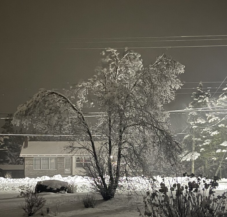
-
If you get a chance, take a look at the Cfs2 on Tropical Tidbits. It has the fun going thru March.
-
How reliable is the AIGFS when it comes to Qpf?? .
-
It holds the sw vort back so it's just overrunning and that can't come north. Though 6z run did weaken the Midwest high pressure.