All Activity
- Past hour
-
 Follow NWS warnings and statements. Probably a good idea to plan altnerate travel plans Sunday afternoon-Monday night. Air travel will be impact as well roads. Deeper bands of heavier gusty rains Sunday night-Monday morning then low top steady light-briefly mdt rain Mon afternoon-night. I could be in error on my take but what am prepared for in the NYC subforum. Am not exactly sure what is out by NWS. I think they have the CFWRNG's out, if not...going to happen, probably 3 cycles of MDT, possibly a major in there Monday-also dependent on the sub basins, especially packing in on the northeast wind. Follow NWS. Coastal flooding also will have a river runoff component at the interface between incoming ocean waves, wind, elevated water level and dealing with 1-3" of rainfall runoff attempt into the ocean-marshes etc. My guess is that the HWA will convert to warnings on the coasts, for sct G50-60MPH, with the warning approach from my view, exacerbated by wet coastal ground, uproots and fully leaved wet leaves breaking branches Sunday evening-Monday. Could see few g45 MPH western NJ/se NYS and CT as well Sun night-Monday morning. Isolated inland flood warning in NJ (Ocean-Monmouth) Monday morning???? if some of the outlier model 4-6" materializes. Rainfall dependent. Modeling and WPC has consistently highlighted Ocean and Monmouth counties for biggest rainfall past few days. WPC trimmed qpf slightly in its early morning forecast. I'm expecting a little more than what they have, similar to early yesterday's 10z/10 forecast. Back later in the day. Will convert headline this afternoon to add OBS, but do add OBS rainfall from today when it occurs.
 -

2025 Atlantic Hurricane Season
NorthHillsWx replied to BarryStantonGBP's topic in Tropical Headquarters
Another lemon in the MDR -

The return of the elusive Nor'easter. Drought buster or bust?
Eskimo Joe replied to dailylurker's topic in Mid Atlantic
This is why you always want to root for the northern stream to dive south of us. We get the warm air adcection precip, the transfer, and the upper level cold conveyor belt on the back side. It's the easiest and most reliable way to win. -

Spooky Season (October Disco Thread)
moneypitmike replied to Prismshine Productions's topic in New England
You're right about those moutntains.....look very fake is a bad photo-shop kind of way. -

Central PA Fall Discussions and Obs
mahantango#1 replied to ChescoWx's topic in Upstate New York/Pennsylvania
-

Spooky Season (October Disco Thread)
HoarfrostHubb replied to Prismshine Productions's topic in New England
Agreed. Super pixelated or something. -

Spooky Season (October Disco Thread)
DavisStraight replied to Prismshine Productions's topic in New England
The one back left looks odd. -

The return of the elusive Nor'easter. Drought buster or bust?
87storms replied to dailylurker's topic in Mid Atlantic
Looks like we're mostly stuck between the NS vort and coastal...with a general lack of phasing. -

The return of the elusive Nor'easter. Drought buster or bust?
Weather Will replied to dailylurker's topic in Mid Atlantic
WB 6Z EURO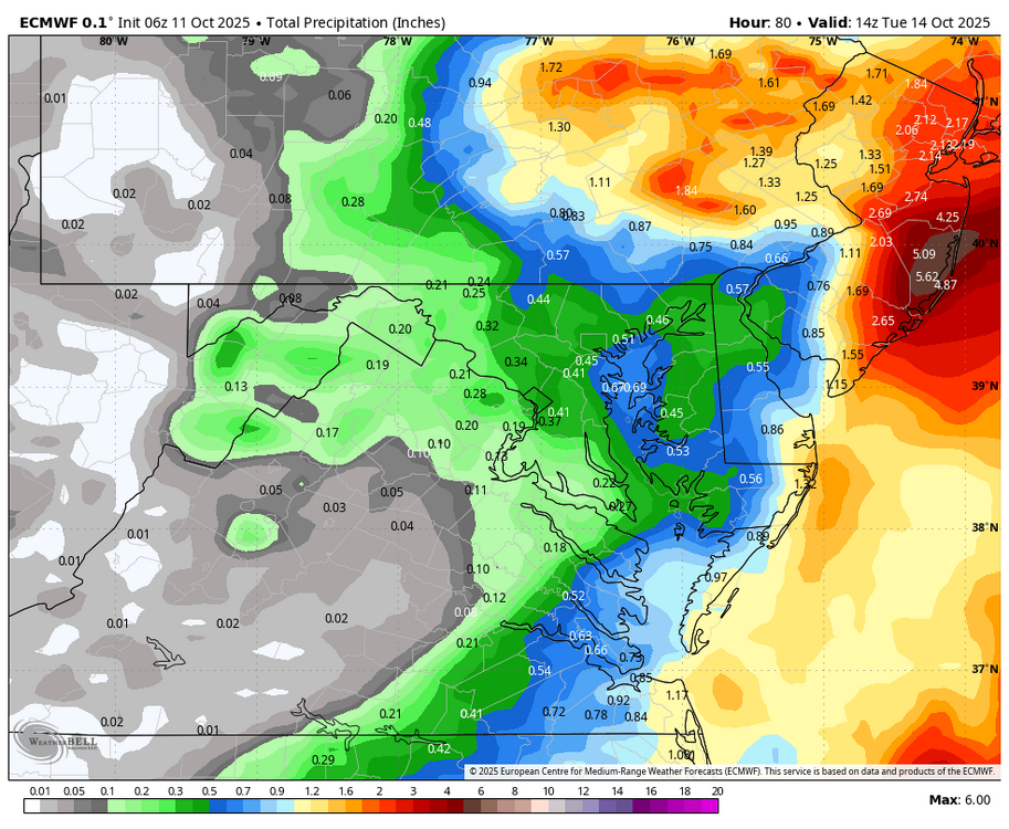
-

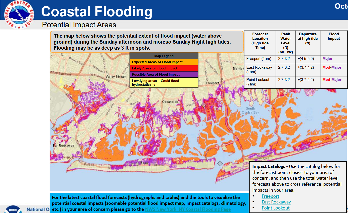
"Potentially" powerful Nor'easter Sun-Mon 10/12-13/25 with needed rain-especially south of I84, and fairly high impact sct coastal gusts 50+ MPH and possibly moderate or greater coastal flooding at the midday Sun and Monday high tide cycles.
donsutherland1 replied to wdrag's topic in New York City Metro
NWS forecast for most significant coastal flood impacts expected for Long Island: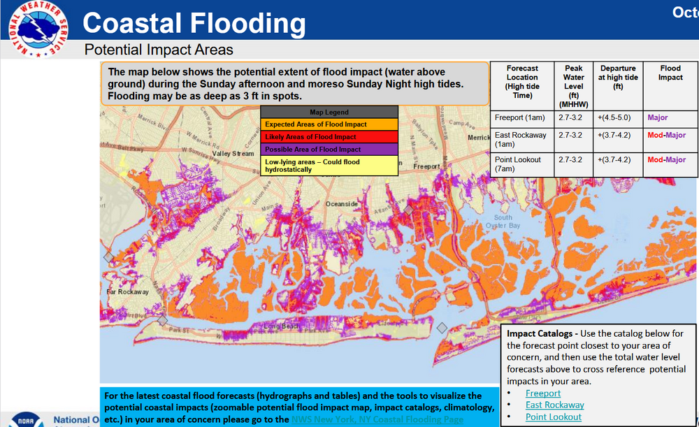
-
Tig ole bitties.
-
Spooky Season (October Disco Thread)
HoarfrostHubb replied to Prismshine Productions's topic in New England
Not sure if this photo is legit. Supposedly the Saco River near Attitash from this past week. Mountains look odd…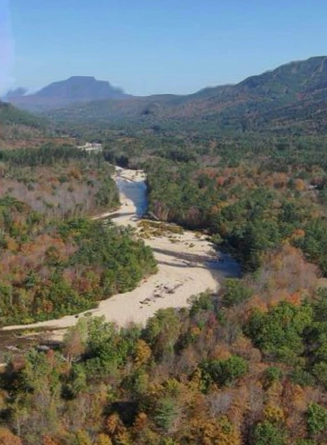
-
Spooky Season (October Disco Thread)
HoarfrostHubb replied to Prismshine Productions's topic in New England
Next week doesn’t look too bad after Tuesday -
All beef, no boobs.
-
Fog and 40.2/39.3 this morning after a 39.2 degree low. High was only 55.8 degrees yesterday with clouds and NE to SE breezes, not a record 'warm minimum' (goes to 1979's 53) but did just eek out the 56 from 1993 for second lowest.
-

The return of the elusive Nor'easter. Drought buster or bust?
dailylurker replied to dailylurker's topic in Mid Atlantic
Yeah. It crushed your area. Pretty solid here too. 1-2" east of 95 to the bay. Flat lands 2-3". -

The return of the elusive Nor'easter. Drought buster or bust?
CAPE replied to dailylurker's topic in Mid Atlantic
lol that would be like 2"+ here. - Today
-
Here's a new one, recently emerging Antarctic methane seeps. Could be an important climate feedback. A priority for research funding I would think; but, we will have to rely on other nations to carry the ball. https://www.nature.com/articles/s41467-025-63404-3.pdf
-
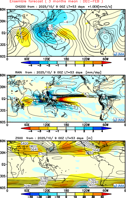
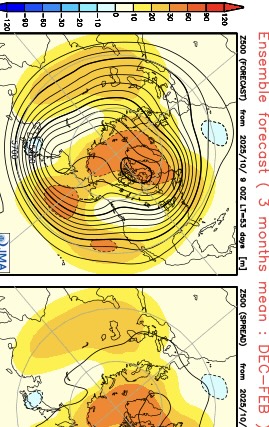
New JMA has Greenland to Eastern Canada blocking linking up with Southeast ridge in the means. Variable PNA with a ridge off the California Coast and an Aleutian ridge. Active storm track through the Great Lakes and a quiet Southern stream. Several elements related to the dominant pattern in recent years. https://ds.data.jma.go.jp/wmc/products/model/map/7mE/map1/zpcmap.php

-
The return of the elusive Nor'easter. Drought buster or bust?
dailylurker replied to dailylurker's topic in Mid Atlantic
I'm hugging the NAM 3k. It looks pretty rainy east of 95 starting tonight. -

Spooky Season (October Disco Thread)
Lava Rock replied to Prismshine Productions's topic in New England
Ablation for pvcs? Sent from my SM-S921U using Tapatalk -
Some station drought numbers... Mtd 0.19" , Last 30 days 0.74" , Ytd 25.70".
-

Central PA Fall Discussions and Obs
Mount Joy Snowman replied to ChescoWx's topic in Upstate New York/Pennsylvania
It surely will be, and we will all handle it like mature adults haha. -
Big Braziers for the Euro…bra it up.
-
I’ve seen your set . Now them some boobies . Bra em up