All Activity
- Past hour
-
I would tend to think right now that the ACE finishes lower than the 161 reading we got for 2024. But there are some similarities to last year so far. 2024 featured hurricane Beryl going CAT 5 in early July. Then no major hurricanes until late September. This year we got the CAT 5 Erin in mid-August and now it looks like perhaps no majors into at least mid-September. So my guess is that Erin won’t be the only major this year.
-
51.7 IMBY this morning. I was up at Fall Creek Falls Monday and Tuesday. I'm not sure what the low temp was Tuesday morning, but it felt like upper 40's. Excellent running weather.
-
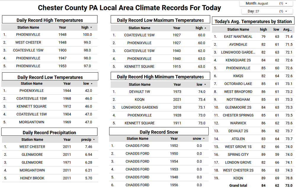
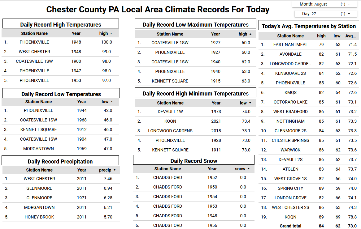
Of note that 45.9 degree low temperature this morning at Warwick Township is the 2nd coldest temperature recorded in the county on this date behind only the 42 degree low back in 1944 at Phoenixville.
-

E PA/NJ/DE Summer 2025 Obs/Discussion
ChescoWx replied to Hurricane Agnes's topic in Philadelphia Region
Of note that 45.9 degree low temperature this morning at Warwick Township is the 2nd coldest temperature recorded in the county on this date behind only the 42 degree low back in 1944 at Phoenixville. -
 and the usual nonsense of posting day 7-10 maps showing 100 degree heat for mid August....
 -
45.1 this morning on my weather station
-

2025 Atlantic Hurricane Season
NorthHillsWx replied to BarryStantonGBP's topic in Tropical Headquarters
I know SSTs are still plenty warm obviously as we approach peak season, but sea temps have fallen across all of the western Atlantic and Caribbean and most of the gulf. A lot is due to Erin in the Atlantic but a lot is due to the train of fronts making very far south for this time of year. In NC many areas woke up to 50s this morning and 60’s made it down to the gulf coast. With more fronts on the way it begs the question of whether SSTs have already peaked in the western Atlantic and whether if a storm approaches that this will help mitigate high end intensity. It is quite literally a 180 from the start of season -

2025-2026 ENSO
PhiEaglesfan712 replied to 40/70 Benchmark's topic in Weather Forecasting and Discussion
The problem with that is many of those seasons were active early, or at least showed signs. 2022 and 2015 are the only one's you could make an argument against, and even those had activity in early September. If the first half of September is not active, then chances are, it just isn't meant to be this year. And that's okay, not every hurricane season is going to be active. Look at 1992 after Andrew, nothing happened in the first half of September, and the rest of the season didn't have a major storm (just 2 Category 2's, in Bonnie and Charley in late September, but nothing close to being as big as Andrew). Erin is almost certainly going to be the big event of the season. It's possible we get a second big storm (like we did in 2007 with Felix), but we're not going to churn out major storm after major storm like in 2005. -
 There were 5000 high posts mixed in with people crying that NYC only got to 99
 -
This is incredible. I hope everyone is enjoying this stretch of weather this is a historically cool period in the middle of summer. We may never get an extended BN stretch like this again for this long as so very few have ever happened. RDU hit 90 1 time in August and many areas in our sub forum never touched it and it is continuing into September. This realistically is likely the coolest extended summer period in many of our lifetimes. Not only the peak departures from normal but the duration of BN is what is making this period stand out
-

September 2025 OBS-Discussion centered NYC subforum
Stormlover74 replied to wdrag's topic in New York City Metro
Euro still has a storm next week but not until Wednesday now. Given its track record of late and no other model support I'd say its a long shot -
Oh I meant that coastal thing
-
First 50’s of the season! Well it’s not even close to fall and we have 50’s anyway! 58.6 this morning and honestly could’ve used a light jacket taking the kids to school
-
 The lower dewpoints allowed the minimums to drive the cooler departures at spots like HPN which have been average for high temperatures. Climatological Data for WESTCHESTER CO AP, NY - August 2025 Click column heading to sort ascending, click again to sort descending. Sum 2123 1611 - - 2 187 2.39 Average 81.7 62.0 71.8 -1.0 - - - Normal 81.6 63.9 72.8 - 2 2025-08-01 73 61 67.0 -6.9 0 2 0.02 2025-08-02 79 58 68.5 -5.4 0 4 0.00 2025-08-03 82 57 69.5 -4.3 0 5 0.00 2025-08-04 87 60 73.5 -0.2 0 9 0.00 2025-08-05 82 66 74.0 0.4 0 9 0.00 2025-08-06 77 66 71.5 -2.1 0 7 T 2025-08-07 80 60 70.0 -3.5 0 5 T 2025-08-08 80 57 68.5 -4.9 0 4 0.00 2025-08-09 82 56 69.0 -4.3 0 4 0.00 2025-08-10 89 60 74.5 1.3 0 10 0.00 2025-08-11 88 63 75.5 2.4 0 11 0.00 2025-08-12 90 62 76.0 3.0 0 11 0.00 2025-08-13 90 69 79.5 6.6 0 15 1.16 2025-08-14 90 71 80.5 7.7 0 16 0.00 2025-08-15 86 71 78.5 5.8 0 14 0.00 2025-08-16 83 70 76.5 3.9 0 12 T 2025-08-17 90 70 80.0 7.5 0 15 T 2025-08-18 74 59 66.5 -5.8 0 2 0.00 2025-08-19 76 57 66.5 -5.7 0 2 0.00 2025-08-20 68 57 62.5 -9.6 2 0 1.17 2025-08-21 72 58 65.0 -7.0 0 0 0.04 2025-08-22 82 56 69.0 -2.8 0 4 0.00 2025-08-23 82 60 71.0 -0.7 0 6 0.00 2025-08-24 80 61 70.5 -1.0 0 6 0.00 2025-08-25 84 65 74.5 3.2 0 10 0.00 2025-08-26 77 61 69.0 -2.2 0 4 0.00 2025-08-27 M M M M M M M 2025-08-28 M M M M M M M 2025-08-29 M M M M M M M 2025-08-30 M M M M M M M 2025-08-31 M M M M M M M
 -
They say 25% of people are not affected by it, 25% are very sensitive (me), and 50% are in between. One year I cleared my 350 foot stone wall of brush, wore gloves and long pants and a long sleeves shirt and still blew up like a balloon.
-
E PA/NJ/DE Summer 2025 Obs/Discussion
ChescoWx replied to Hurricane Agnes's topic in Philadelphia Region
This morning was our chilliest morning of the late summer/early fall season. Many of the area lower valley spots fell into the mid to upper 40's including Warwick Township at 45.9 / Nottingham 47.0 / Avondale 49.5 / Kennett Square 48.7 / West Bradford 47.8. The higher ridge locations stayed in the lower 50's. We should see a repeat with similar temperatures tonight. Our below normal temperatures will continue through the week and into next week. The "mildest" day looks to be tomorrow, but it will still feature temperatures still several degrees below normal for the end of August. Another cold front crosses the area tomorrow night and we should again see nights in the 40's for those valley locations both Saturday and Sunday morning. Only a very slight chance of a shower on Friday otherwise another dry week in what has been one of our driest August months on record.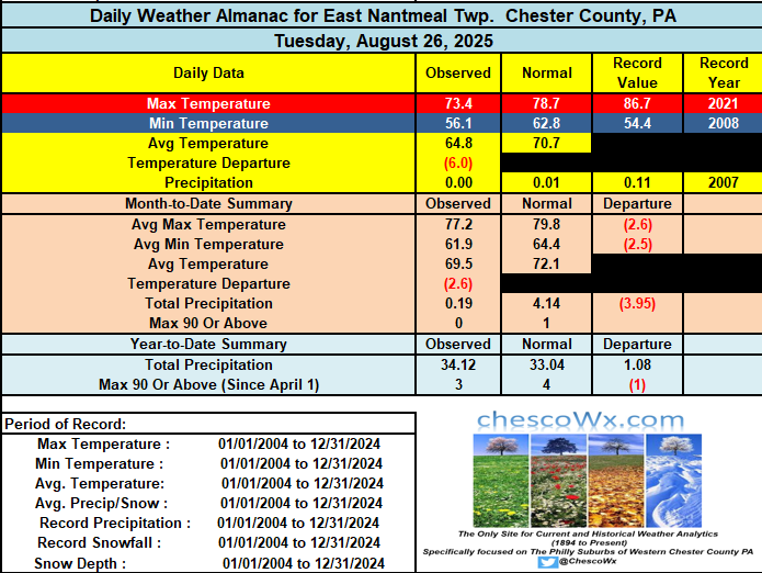
-

Central PA Summer 2025
Mount Joy Snowman replied to Voyager's topic in Upstate New York/Pennsylvania
Could be wrong but I believe we have our first "official" reading in the 30s for Pennsylvania, as BFD hit 37 last night. -
Thanks Mount Joy!!
-

September 2025 OBS-Discussion centered NYC subforum
wdrag replied to wdrag's topic in New York City Metro
fwiw...5H pattern is looking interesting for me here as of the 06z/27 ensembles. my interest is west of I95 where it's been pretty darn dry since the 22nd. Am I seeing opportunity for for 1/2-2" of rain in nw NJ next week beginning periodically Monday night Sept 1? -
Sept thread started... this above added to Sept.
-
Canaan is a relatively short drive for me so when my Dad was visiting this weekend, we drove by there and mentioned how us weather nerds follow their temps like gospel. Interesting that today, it's the coldest in the country. Even for a guy who couldn't care less about weather, he finds it fascinating that a locale near us can be that cold. Wish I could have a cabin smack in the middle of it.
-
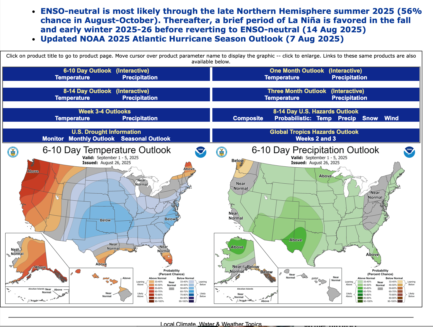
Am not using GEFS predictors etc beyond 2 weeks and messing up the anticipation mid month onward, like the August 2025 post. Instead I've added the 6-10 day issued yesterday, as well as the page you can go to look at CPC's daily updates of 6-10, 8-14 day, the weekly Friday updates of the 2-3 week and twice monthly updates of the monthly outlook, as well as other occasionally helpful predictors, based on the still nascent developing long ranging science beyond 2 weeks. https://www.cpc.ncep.noaa.gov
-
 where was all this lowposting when we were breaking records last month
 -
Yeah, late seasons have been very active since Sandy back in 2012.


.thumb.JPG.418e8a9a2902ae687ec35ff4bc0e038e.JPG)