All Activity
- Past hour
-
1.52"
-
Radar indicated tornado Talbot/Southern Caroline county
-
Clear skies up north but watched all the darkness south while playing softball
-
Thank god I missed all the severe weather.
-
(002).thumb.png.6e3d9d46bca5fe41aab7a74871dd8af8.png)
E PA/NJ/DE Summer 2026 Obs/Discussion
ChescoWx replied to PhiEaglesfan712's topic in Philadelphia Region
Some area rain amounts so far from this afternoon. KOQN 1.30"/ East Nantmeal 0.95" / Devault 0.75" / Warwick 0.46" / Chester Springs 0.11" / KMQS 0.03" / Glenmoore 0.08" / Nottingham 0.20" Kennett Square 0.30" / West Chester DEOS 0.71" -
Just over 0.1”. A few good thunder claps in the last hour. Top 5 event of the storm season lol
-

Junorch obs and discussion 2026
Damage In Tolland replied to Damage In Tolland's topic in New England
To what ? -

2026 Mid-Atlantic Severe Storm General Discussion
Ellinwood replied to Kmlwx's topic in Mid Atlantic
Got meh'd IMBY but I'll take the rain I did get. Interesting that we did manage to get several tor warns in MD today.
- 862 replies
-
- 1
-

-
- severe
- thunderstorms
- (and 7 more)
-
0.62" and pouring
-
Should be used to it
- Yesterday
-

E PA/NJ/DE Summer 2026 Obs/Discussion
RedSky replied to PhiEaglesfan712's topic in Philadelphia Region
Local crops needed every drop and much more -
Junorch obs and discussion 2026
Damage In Tolland replied to Damage In Tolland's topic in New England
Hope so . Would love to be wrong -

-
E PA/NJ/DE Summer 2026 Obs/Discussion
RedSky replied to PhiEaglesfan712's topic in Philadelphia Region
Gully washer at qtown Walmart probably couple inches, .80" back at the homestead -
Florida in July? Yuck.
-
Hopefully your chainsaw breaks!
-
here we FUCKING GO AGAIN. ANOTHER FUCKING MISS
-
Lots of convection down there
-
I hope you get 17 inches. Maybe then you'll stop.
-
Wye Mills mesonet 1.7" Ridgely an inch so far
-

Central PA Summer 2026 Discussion/Obs Thread
Voyager replied to Voyager's topic in Upstate New York/Pennsylvania
I got .36" so far, but that was nothing but a few light to moderate showers. No storm whatsoever. -
I am right in it on the northern edge here. Hoping to salvage a half inch or so. Places just south are likely going to get 1-2"
-
Yes. Looks like a wet microburst.
-

Wet late Monday 6/22 or another Fizzle?
nw baltimore wx replied to Weather Will's topic in Mid Atlantic
Rough cutoff line here. Just a trace..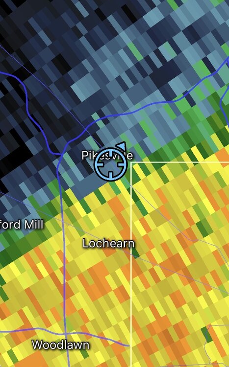
-
At Little River Tpk and Braddock Rd, a big 20 min gully washer, weak T&L, and surprising, no wind whatsoever.