All Activity
- Past hour
-
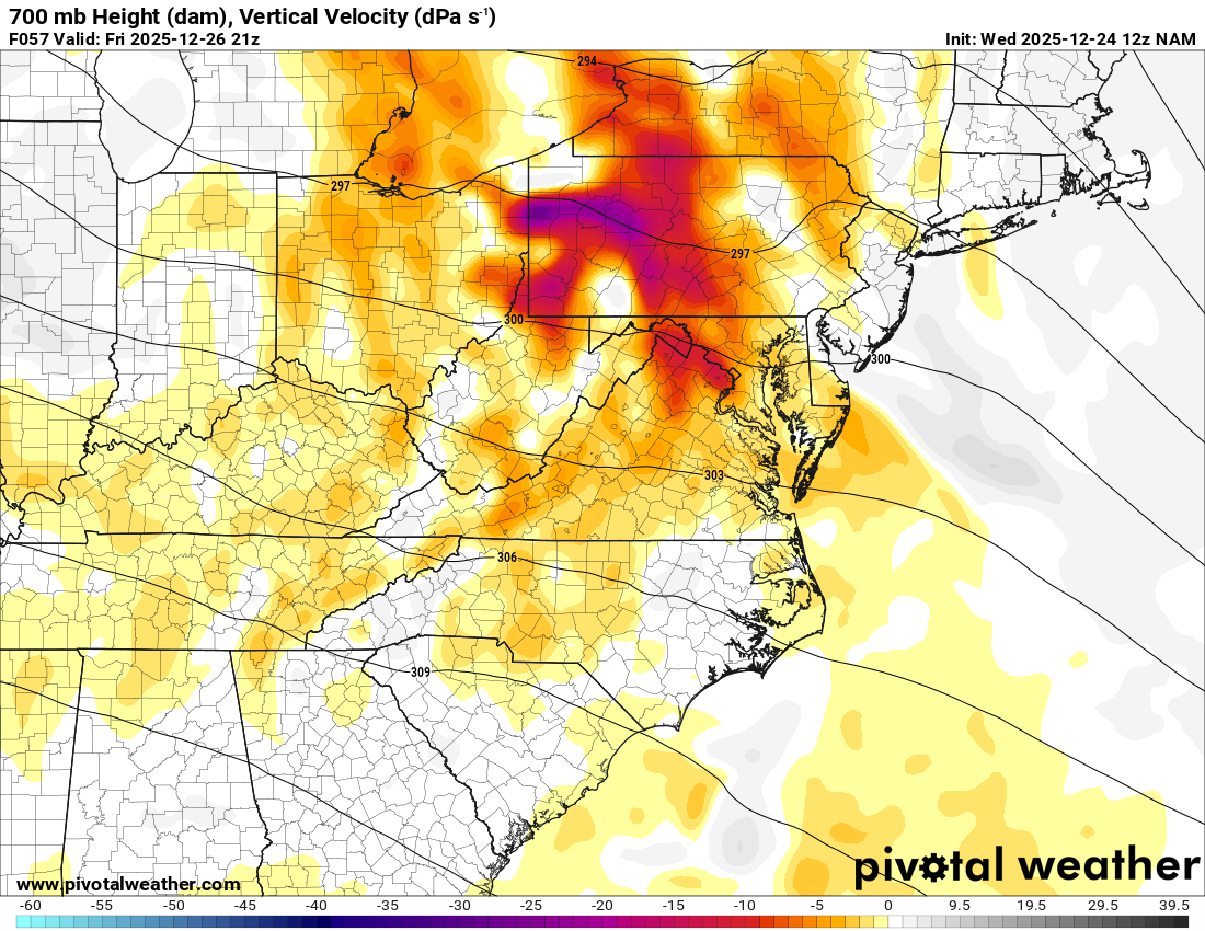
Decent vertical velocities approaching the area at 57hrs on the Nam.

-
Looks about right. A non issue for most on the board.
-

26th-27th event, coming at us like a wounded duck.
Sey-Mour Snow replied to Go Kart Mozart's topic in New England
No doubt, definitely losing forcing as it approaches, euro pukes 1-2" rates for a few hours then just light snow after.. -
64 already. What a beautiful morning.
-
Back in another band now,
.thumb.jpg.764cd837a84501f1226806e085eea722.jpg)
-

Central PA Winter 25/26 Discussion and Obs
Jns2183 replied to MAG5035's topic in Upstate New York/Pennsylvania
Sleet bombs bring back some pretty core childhood memories around this area. It's a mid 90's throwback kinda December! Sent from my SM-S731U using Tapatalk -
No. Just wondering what's going on with them. Never saw them be so contrary to other guidance. Maybe some usual members missing? Idk
-

Winter cancelled/uncancelled banter 25/26
NorthShoreWx replied to Rjay's topic in New York City Metro
I'll check it out. I haven't had TWC in over 2 years. I thought I'd miss it, but I didn't. -
lol @ at the very concept of “last minute mid Atlantic victory”
-

26th-27th event, coming at us like a wounded duck.
weatherwiz replied to Go Kart Mozart's topic in New England
That's good. I'm not sure what to think of that...I am thinking that the dry air would probably be on the backside of the precip which could could help with some heavier rates. Would see a scenario of where it rips like 1-2" for a few hours then shuts off. Lots of details to iron out today -
A lot of that is from the Christmas Day rain if you look at the hour 27 6 hour QPF mean.
-
RRFS covering itself in glory before it is even used in forecasts
-
At peak overnight, We were pushing 3"/hr rates.
-
26th-27th event, coming at us like a wounded duck.
Sey-Mour Snow replied to Go Kart Mozart's topic in New England
I just checked on WB for EURO , looks fine for SWCT, we'd pound , NE of here obviously much drier on euro, gfs def much drier here at onset in mid levels.. -

26th-27th event, coming at us like a wounded duck.
TauntonBlizzard2013 replied to Go Kart Mozart's topic in New England
Confluence a bit weaker this run on the NAM. Probably going to bump north a bit, but again, really small changes -
Same.
-

26th-27th event, coming at us like a wounded duck.
WinterWolf replied to Go Kart Mozart's topic in New England
He might be overthinking this too lol..kind of like what happened last week. -

2025-2026 ENSO
40/70 Benchmark replied to 40/70 Benchmark's topic in Weather Forecasting and Discussion
@MJO812Congrats....I was wrong on December snow in NYC, and you were right. Reason being I missed the late month blocking. Let's see if you guys get above my 19-29" seasonal call. -
26th-27th event, coming at us like a wounded duck.
weatherwiz replied to Go Kart Mozart's topic in New England
I wanted too but I guess they're only available on pivotal-plus now and I don't know where else they are available but I would really be curious to see what they look like. When I started looking at soundings I had to double check the time stamps were correct and whether maybe they loaded in error...that's how bad they look lol -
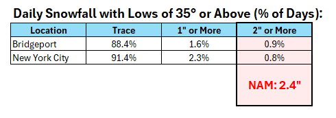
 The combination of the warmth (the daily low temperature wound up at 35° in NYC), light precipitation rates, and warming at the mid-levels all suggested that the 2"+ NAM amount was unrealistic for the City. At that time, the forecast low was 33°-34°, but the NAM idea was unrealistic. With lows of 35° or above, a trace was by far the most likely outcome. The same would hold elsewhere in the NYC region at such an elevated low temperature. For example, below are the historical statistics for Bridgeport (1948-present) and New York City (1869-present): And here was the NAM map:
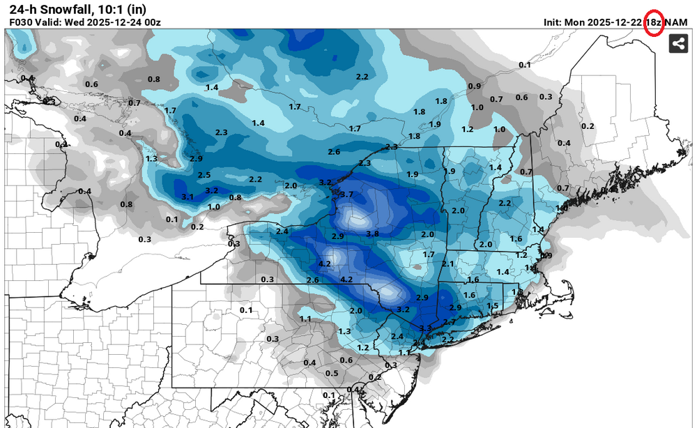
-

White Christmas Miracle? December 23-24th
rimetree replied to Baroclinic Zone's topic in New England
Looks like were getting into some of the dong now. About 2.5" so far. 27/25 -
26th-27th event, coming at us like a wounded duck.
Sey-Mour Snow replied to Go Kart Mozart's topic in New England
Did you get to look at Euro soundings, I wont be able to get on my PC til later -
at this point just need some form of precipitation - finishing the year missing about a quarter of the normal annual precip here.
-
Ratios will be high if temps are in the 20s. Thats what he is going with. I like 3-6 for NYC but I can easily see more with the banding. Lets see where we are at tomorrow.
-

26th-27th event, coming at us like a wounded duck.
WxWatcher007 replied to Go Kart Mozart's topic in New England
He's in a far worse spot than CT is, even though he's not that far away in the whole scheme of things. Small changes can work for CT. They need something bigger. And the trends aren't linear as you know. We can trend wonderfully today and lose all the gains tomorrow.


.jpg.8848e5e20da419b96889a4f78c56f068.jpg)


