All Activity
- Past hour
-
rainfall numbers under performed for nyc..
-
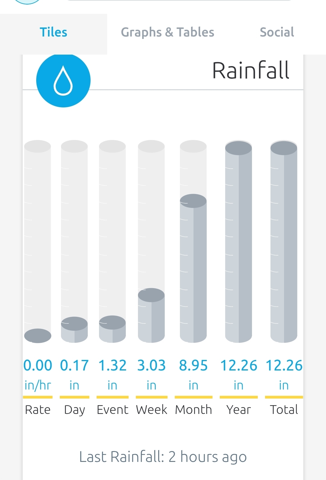
1.89" since the start time at 12:52am which makes 8.66" for the month. Still raining just under a half inch per hour rate, 57/55.
-
Should get some sun this afternoon before the “stinger” moves back in. Maybe we can destabilize and pop some cells.
-
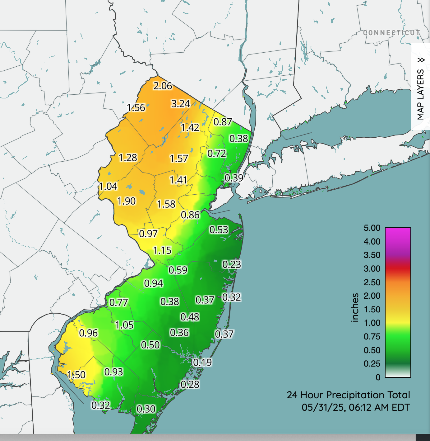
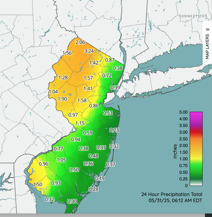
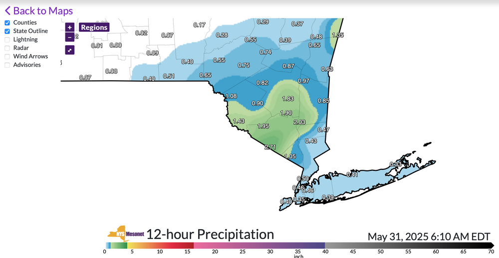
My remote AWN in Wantage NJ has 1.85 since midnight,, probably a bit less but close. Added NJ and NYS mesonet climate network maps past 12 hours. Representative. Click for clarity if interested.
-
Missed all the heavy storms 0.55” total
-
.44F here, just enough. Thinking maybe add another .50” worst case.
-
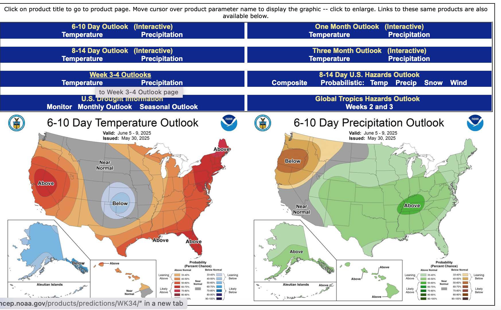
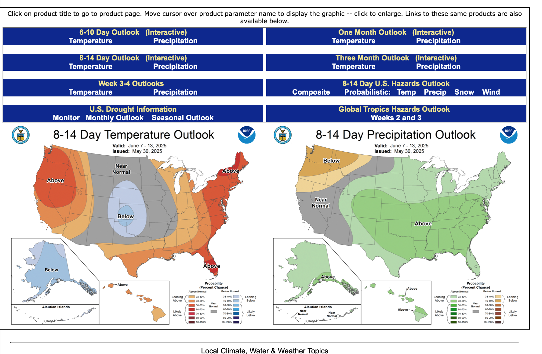
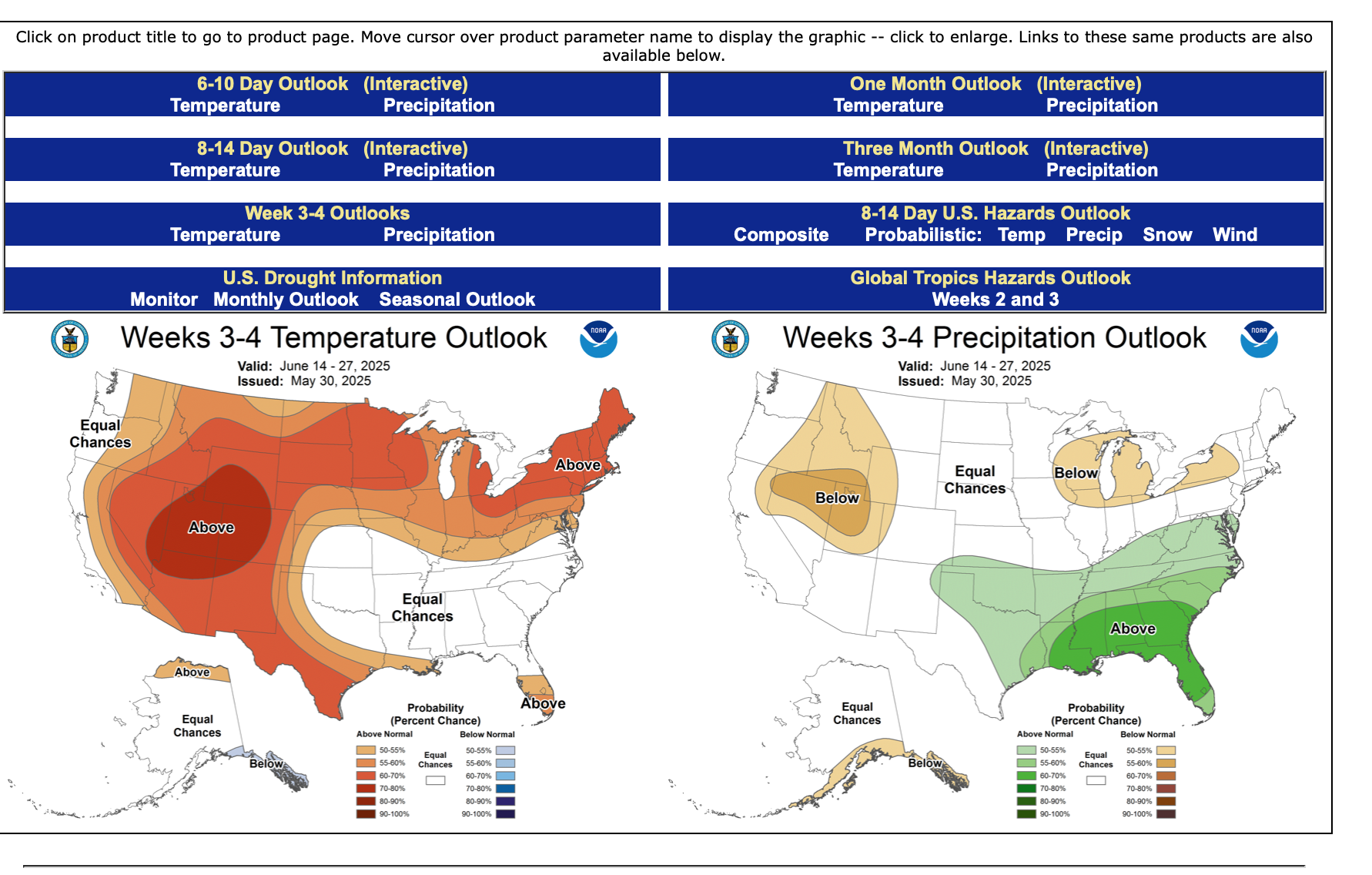
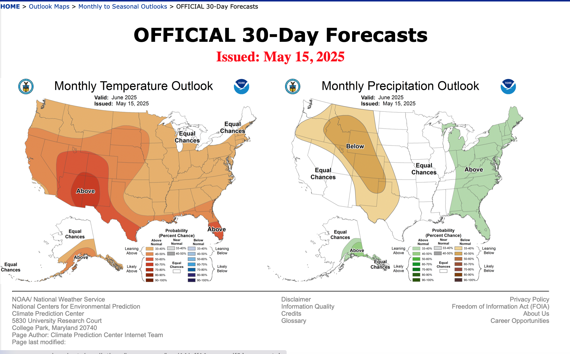
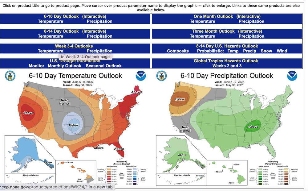
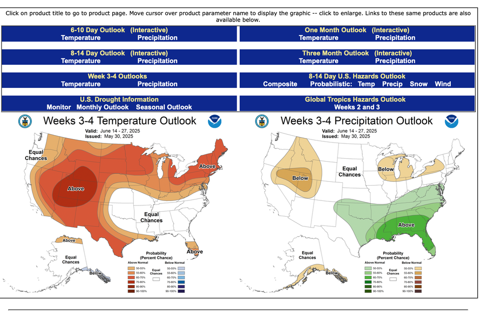
And the D 6-10, 8-14, Week 3-4 as issued yesterday May 30 for June, and the June outlook issued May 15 which I think gets updated in the next day or two.


-
Finished off with .71. Another .2 overnight
-
1.72 for this event so far and 9.02 for the month.
-
Dang just missed a 9" month still a pretty impressive 30 days

-
Had a solid flash and bang of thunder around 4:00 am. Woke up the baby and the dog. Cleared out for now with some decent winds.
-
Storm is almost over. What a stupid event.
-
Just noticed, too, that I'm in a flood warning until 6:15am. ...FLOOD WARNING IN EFFECT UNTIL 615 AM EDT THIS MORNING... * WHAT...Flooding caused by excessive rainfall is expected. * WHERE...A portion of central Pennsylvania, including the following counties, Columbia, Dauphin, Lebanon, Lycoming, Montour, Northumberland, Schuylkill and Sullivan. * WHEN...Until 615 AM EDT. * IMPACTS...Flooding of rivers, creeks, streams, and other low-lying and flood-prone locations is imminent or occurring. Streams continue to rise due to excess runoff from earlier rainfall. * ADDITIONAL DETAILS... - At 319 AM EDT, gauge reports indicated heavy rain. Flooding is ongoing or expected to begin shortly in the warned area. Between 1 and 2 inches of rain have fallen. - Additional rainfall amounts up to 1 inch are possible in the warned area. - Some locations that will experience flooding include... Bloomsburg, Pottsville, Berwick, Sunbury, Shamokin, Tamaqua, Mount Carmel, Shenandoah, Danville, Minersville, Mahanoy City, Frackville, St. Clair, Kulpmont, Ashland, Valley View, Mcadoo, Elysburg, Pine Grove and Fairview-Ferndale.
-
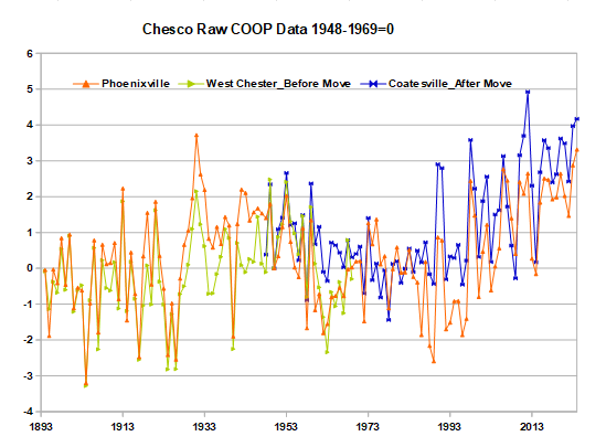
Your chart is mislabeled. Nobody measures the average temperature of Chester County and there is no raw data in your chart. Instead you are showing the results of NOAA's and your calculations. NOAA is completely open about their methods. Their goal is to remove the station changes from the raw data, leaving only the month-to-month weather. While NOAA has removed the station changes, you have left them in. Furthermore you have added a number of stations that NOAA doesn't use at the very end of the period, mainly 2014+. These stations don't contain much climate data due to their short record; but, do cool the present somewhat since they are cooler on average than the NWS coop stations. There isn't much difference between your results and NOAA's after 1970, steady warming of 3 to 4F over that period. The big differences is the period before 1970. There are only 3 COOP stations with significant data before 1970: Coatesville, West Chester and Phoenixville. All 3 were much warmer than the county average temperature. That's why your results are so warm before 1970. We have reviewed the raw data from those 3 stations over and over again. Coatesville and West Chester moved from towns to less built up locations and cooled by 2F. While Phoenixville ran much warmer than surrounding stations in the 1930s, 1940s and 1950s due to higher afternoon temperatures and time of day bias. The chart below shows raw data from the 3 main Chesco COOP stations with the Coatesville and West Chester moves removed. The chart is 100% raw data. To better isolate the long-term climate trend, differences between stations have been removed by subtracting the average temperature between 1948 and 1969 from each station. In complete agreement with NOAA, the raw data shows considerable warming in Chester county since 1893. There is no doubt that Chester County has warmed. The large cooling that you show between 1940s and 1970 is spurious. A result of the station moves at Coatesville and West Chester, and cooling at Phoenixville as it lost the warm bias of the 1930-50s. The bottom-line is that NOAA and you have both met your objectives. NOAA has removed the station changes and isolated the county long-term climate trend; while, you have altered our local climate to bring it into alignment with your worldview.
-
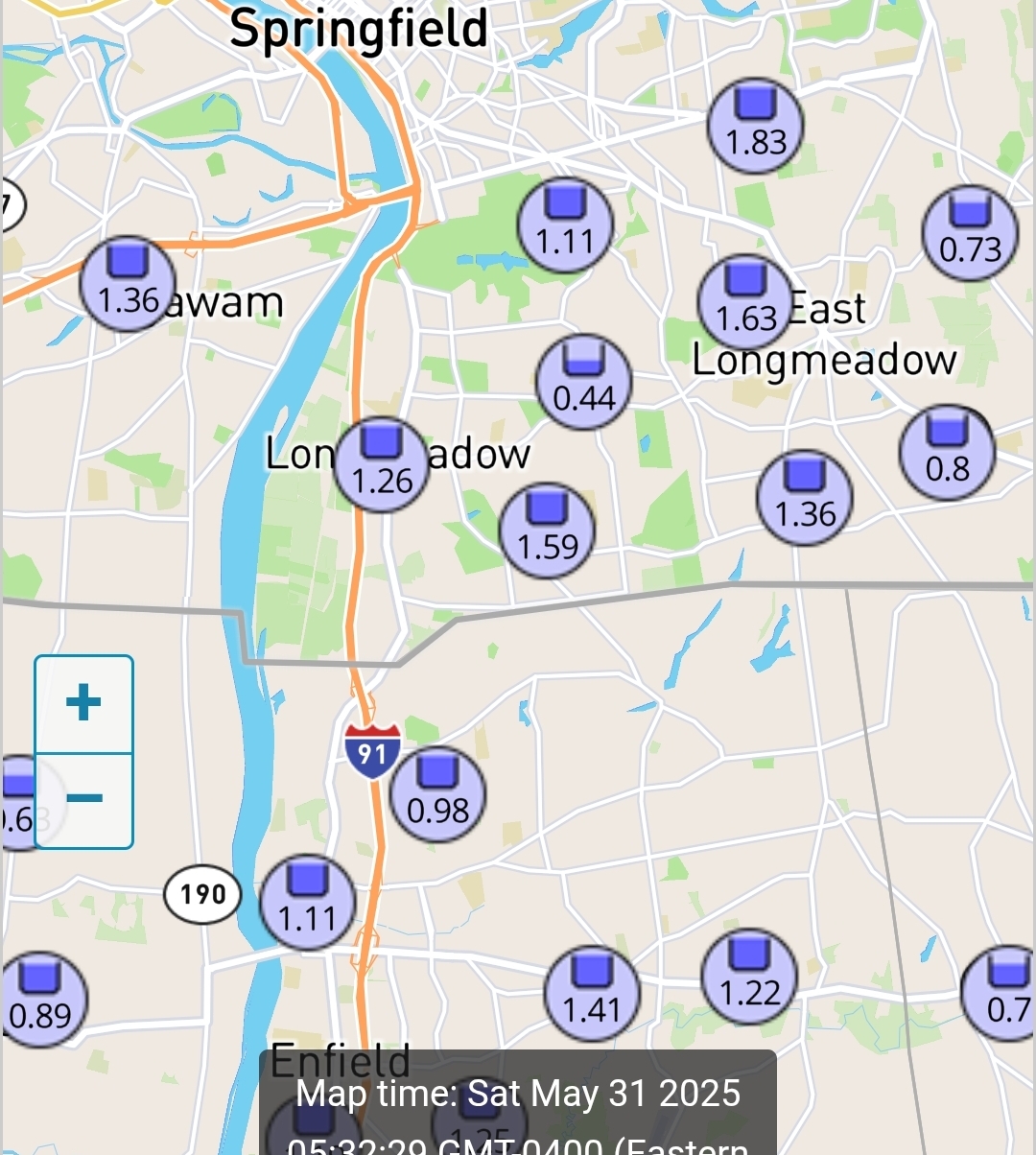
Springfield area got a nice soaking.

-
Not too bad here. 0.15 and doesn't look like a whole lot More with the morning rain.
-
Delayed, but not denied. 1.62" as of my 5:30am wake up.
- Today
-
59.3° RA
-
 Gillor6 joined the community
 -
What happened to the storm? Lol. I had a thunderstorm for 10 minutes last evening. What's the wind advisory and flood watch for?
-

E PA/NJ/DE Spring 2025 Obs/Discussion
RedSky replied to PhiEaglesfan712's topic in Philadelphia Region
1.30" 11.90" for May! Heard local farms have lost their corn plantings for the first time they can remember. -

2025 Atlantic Hurricane Season
WxWatcher007 replied to BarryStantonGBP's topic in Tropical Headquarters
GFS running hot but the signal for a window is still there. Most likely after the 8th or so on both the EPS/GEFS. -
Wow. Now that’s incredible.
-

E PA/NJ/DE Spring 2025 Obs/Discussion
Kevin Reilly replied to PhiEaglesfan712's topic in Philadelphia Region
Over here just lifted north Low right on top of Media heading NNE winds clouds switched around to the NW a few minutes ago. Ended with exactly 1.00” since 8:30 pm. witnessed a tree on fire and telephone pole on fire from tree falling Barren Road and Painter Road Middletown Twp Delaware County. I called 911 fire police on scene in minutes. Great job!!! -
That is some crazy heavy rain
-
<3