All Activity
- Past hour
-
 Only Ineedsnow would say MEH to a 140 kt STY! It's the CoastalWx equivalent of saying MEH to 6/1/11.
 -
Take a look at this short paper from 2004. Odds are it has been exceeded, and since 2004? Several candidates (Haiyan in Nov 2013 almost certainly). strongerTC.pdf
-

E PA/NJ/DE Summer 2026 Obs/Discussion
Albedoman replied to PhiEaglesfan712's topic in Philadelphia Region
https://www.mcall.com/2026/07/03/lehigh-valley-storm-damage-photos-july-3-2026/ -
If we only have recon in these monsters. I will tell you given what recons measured from the 1940s to 1987 in the WPAC, if it was done today w/ the much more advanced tech such as GPS dropsondes and the SFMR, you want to talk records and extreme that would put all to shame what we have seen in recons in the ATLC? The few research mission recons we have had over the years in the WPAC have shown incredible stuff. Satellite estimates can only do so much. Dvorak estimates work best for TCs between 60 and 105 kt. This means two things - 1) many TDs are actually weak TSs, and 2) most very intense TCs are underestimated. The inner core of these things are strange beasts, acting more mesoscale than anything when you get to Cat 5 levels. EPAC Patricia in 2015 would have been capped at 160 kt from satellite estimate only, but recon actually found 185 kt winds. As a result of the above, TC intensities and annual ACE globally are underestimated, and the further you go back, esp. prior to the satellite era, the more off it is. And really w/ recon, we only started to see things in proper detail w/ the advent of the GPS dropsonde in the late 1990s and the SFMR in 2004. So you can't really use the database we have over the long-term for true TC trends.
-
E PA/NJ/DE Summer 2026 Obs/Discussion
Albedoman replied to PhiEaglesfan712's topic in Philadelphia Region
Yep my area was the hardest hit from the these storms this evening- from 102 temps down to the mid 70's comes with derecho type straightline winds like I said earlier this week could happen. Only .31 in of rain but the winds were bad. Spent an hour picking up dead limbs/branches in the yard and street. this happened less than 1 mile from the house---- Severe thunderstorms moved through the Lehigh Valley on Friday evening, temporarily dropping temperatures amid the extreme heat, but also causing significant tree damage that cut power to thousands of area residents just as Fourth of July celebrations get started. Some of the worst storm damage was reported in the Alburtis and Macungie areas, where numerous downed trees dotted the landscape. Alburtis declared a “state of emergency” due to the damage. “Please avoid unnecessary travel, stay clear of downed trees and power lines, and follow all guidance from emergency personnel,” according to a post on the borough’s Facebook page around 9:30 p.m. “Updates will be provided as crews continue assessment and restoration efforts.” One tree fell onto a house on West Fifth Street in the borough, tearing away part of the roof. A freight train was also stopped in the borough due to a large tree that fell on the tracks, blocking both railroad crossings on North Main Street and West Penn Avenue. As of 8 p.m., PPL’s outage map reported nearly 12,000 customers without power in Lehigh and Northampton counties. Areas reporting more than 1,000 outages included Washington Township, Upper Milford Township, South Whitehall Township and Lower Macungie Township in Lehigh County, as well as Northampton borough and -

E PA/NJ/DE Summer 2026 Obs/Discussion
LVblizzard replied to PhiEaglesfan712's topic in Philadelphia Region
Power outage map looks pretty crazy. It looks like literally everyone in East Greenville, Pennsburg, and Red Hill - and the surrounding 5-10 miles - are without power. -
Not sure if it will intensify much after passing the Marianas. It already had its first absolute peak on Fri, and now has leveled off at 140 kt. The eye is currently 30 nm in diameter which is quite large for such a low latitude and so early that far E in this tropical basin. Just saying that if you want a weenie super-duper intense TC, you want to see a pinhole eye, and Bavi never had that, and once the eye gets large, it does not go back the other way. Since the Bavi will slowly gain latitude and undergo ERCs, the eye should only increase in size. Might become an annular TC in fact (the "truck tire" look!). Annular TCs can still be intense (Isabel in Sep 2003 was 140 kt and a classic annular TC), but they tend to stay steady-sate for a long period of time once getting that structure. Ineedsnow will have live Guam radar up 100% of the time for the next several days?
-
One thing that is apparent, when you look at deep at historical data and wx events of the past, you find many that match or exceed anything today or in recent years. But history be damned in favor of the narrative. A friend of mine who gets the small wx calendars that you remove a page a day, he notes obvious bias as to historical wx events. He has told me it is like nothing ever happened/existed before 2000. All it talks about is extremes in recent years. So when I say "narrative," I am not pulling things out of thin air. You can see clear bias and skewed facts all over the place w/ disingenuous motives. All I am saying is that *all* data/info be reported on or put forth, esp. in the sciences, since it is objective and based on fact. Then individuals can at least make educated and reasonable points/views/opinions.
-
Just got a rumble of thunder out of nowhere
-
So BDL unperformed overall. GFS MOS had 103 Thu/Fri 18z 7/1 and 00z 7/2 runs and still just after was showing 101/102. Yet "only" 100 and 98 the 2 days. Wasn't due to convection or clouds. Any long-term MOS bias for BDL? I think the only reason why BOS hit 100 Fri was due to NW subsidence and the DP dropping to 57. What the MSM and others don't tell you or report is that once the dew point drops to 57 or lower, that heat index is actually *lower* than the air temp. BOS 100/57 at 3pm gave a heat index of 99.
- Today
-
 I think a big missed effect of these much higher dews and in turn much higher night time temps is to increase SST’s a lot faster than one would expect… We get it though—without much thought— but only when this is observed in our back yard pool temp…
 -
This thunder is loud af. I love it
-
Looking at the 04/00z NAM 700 analysis, a large area of +12 C exists over the region. 00z IAD sounding had +12.2 C at 700. +12 C at 700 typically caps things solid this time of year, at least locations near sea level. Today it cools ever so slightly at 700, and at 500 for that matter, and the ridging aloft weakens a bit. so we get more flow aloft, esp. at 700. Sfc T/Td basically the same as Fri so things should light up very well later the in aftn! CAPE 3000-4000 and decent mid-level lapse rates, so wet microbursts common. There is no 0-3 km CAPE, so tor threat is nil (LFC to high). Cloud bases should be fairly high so good photo ops. Winds 850 and below very light so storm motion may be slow and more mesoscale impacts to motion (back-building). Should see some big rains in some areas as PWATs juice up nicely right over the region during the day. Sun-Mon looks essentially the same w/ even more impressive PWATs. We do need the rain badly!
-
Reading between the lines I think it means they are doing little or nothing until daybreak.
-
That was intense. I thought we were getting a tornado
-
Got the same, good times.
-
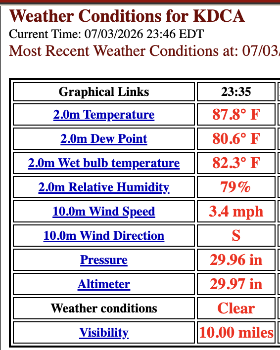
wow - 80 degree dewpoint at DCA
-
99 high with max HI 107.6
-
Agreed!!! Lets go for it. Records for everyone hopefully.
-
Sorry to hear your power is out. We just missed the rain but if I had to choose I will take the miss and keep the power on.
- 318 replies
-
- 1
-

-
- severe
- mountain snow
- (and 1 more)
-
yeah 89/76 here - miserable.
-
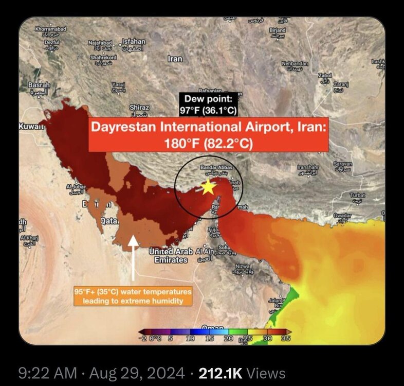
Thanks for the overview summary. Dew points often have even bigger issues than temps are ASOS/AWOS sites. I years ago looking at the OK mesonet (first installed in the mid 90s). Mesonet sites are typically sited properly and actually geared for climate data (ASOS/AWOS are geared more toward aviation). So many days when it was hot and high dew points, the ASOS/AWOS would almost universally had higher dew points than the mesonet. Well, they both can't be right! I'd take mesonet data over ASOS/AWOS the vast majority of the time. I recall about 10 years ago during a heatwave, JFK's ASOS DP got wacky and shot to 84 one day. Not sure what happened there. Also, there are so many types of wx stations our there (govt and private), all for different uses. Some are sited to monitor the local environment, like a marsh or a swamp. So what do you think the dew point will do when the equipment is next to or in a marsh/swamp? It's similar to all the marine sites out there. The anemometers are not all at the standard 10m elevation, so you have to account for this when talking records and the like. AWOS sites on oil platform heliports in the Gulf are often 100 ft or more ASL. Oh, and how about the AWOS at the smaller airports in the Corn Belt? IA has it a lot where at a certain times in the summer, the DPs get into the 80s. That is a local effect since corn has high evapotranspiration. However, at times this can impact convective initiation and intensity in the state and adjacent areas! A few papers has done studies on this. For the Persian Gulf, dew points in the 90s are a real thing in some areas. Qeshm Island (METAR code: OIKQ) in Iran is one such area. Every August in the mornings, they get ridiculous DPs in the 90s w/ heat indices as high as 180! I've checked the METARs and they are legit, given the location and how diurnally the dew points drops in the aftn as the BL mixed out. And the island's population is 149k. Quite impressive that humans can live in such an environment w/ little issues!
-
I don't recall it.
-
When's the last time we had heat indexes this high at this time of night? I mean...bruh, lol
-
Messi was leaving the pitch and the look on his face was - we really dodged a bullet there.


