All Activity
- Past hour
-
how can it get to 110% is the 10% extra if it overflows?
-

Central PA Spring 2025
Itstrainingtime replied to canderson's topic in Upstate New York/Pennsylvania
Tomorrow night could turn into a soaker east of the main stem Susquehanna: -
they are overflowing? how does it get over 100%?
-
https://x.com/NWS_MountHolly/status/1920194735018303931?t=7VPaYVaxrwTaqUYrZpfkRQ&s=19 Confirmed Tornado
-
The weather today is sublime for May. My walk this morning was 3.28 miles of bliss. I will enjoy every second before the heat and humidity rears its ugly head in a month.
-
Does this bleed over into other NCEP models as well? NAM, CFS, RAP? If so, going to make forecasting the rest of chase season a b****.
-
-
What are nj's?
-
- Today
-

Spring 2025 Medium/Long Range Discussion
Spartman replied to Chicago Storm's topic in Lakes/Ohio Valley
12z Euro: 12z GFS: 12z Canadian: Both 12z GFS and Euro runs are hinting a cutoff low and blocking pattern just before Memorial Day weekend. Quite trainwrecky, for sure. 12z GFS: 12z Euro: This month really needs a Reset button. -
Btw ... we're entering the solar maximum. for the next 92.change days we'll be doing caucasoid chromosomal damage controls ..
-
yeah, noticed that it's sped up some. originally - like 6 days ago - that one plunked down in, phased, and retro'ed the whole of it to make it one big shitty choke fest for 5 days. i was even dreading 2005 in a thought. not the case any longer.
-
I certainly don't like black flies - some years ago I tripped in the woods north from Flagstaff Lake and cut my palm. The little horrors thought "It's a buffet!" and landed by the dozen. However, I despise deerflies even more, especially in the far north of Maine. Imagine 50 of them swarming around, accompanied by 100+ similarly sized but non-biting "sweat lickers" on a hot day. One cannot tell which of the little bombers carry knives, nor can one run fast enough to escape. I've never been chased out of the woods by bugs, but that scenario has come the closest. Sun! (peeks only)
-
Each decade had some rats. I think we see the prime heat this year in August, not to say Jun and Jul wont have their fair share of heat, but Aug could be noteworthy heatw-wise
-
Kind of opens up and moves along so even if it did come by...I don't think it's a multi day screw job.
-
Any other years that you want to cherry pick out that were very cold? How many were warm and everyone was wearing shorts, probably most of them I would imagine. And yes, if it got that cold again, it would be maybe 35 instead of 32 and still be a top cold spell. You're too dramatic.
-
ny reservoirs are at 100.7% capacity..
-
should finally all be rotated away tomorrow...but again, Friday - ooph Couple winners, Mom's day through next Tuesday ...then we'll see if that TV vortex that really shouldn't be there, goes on to stress physics in order to fuck with us and actually pulls it off. lol
-
It’s already up here. Turned to shit around noon.
-
67.2° SCT/BKN Nice day but more rain approaching
-

Report: Another Year of Record Heat for the Oceans
GaWx replied to donsutherland1's topic in Climate Change
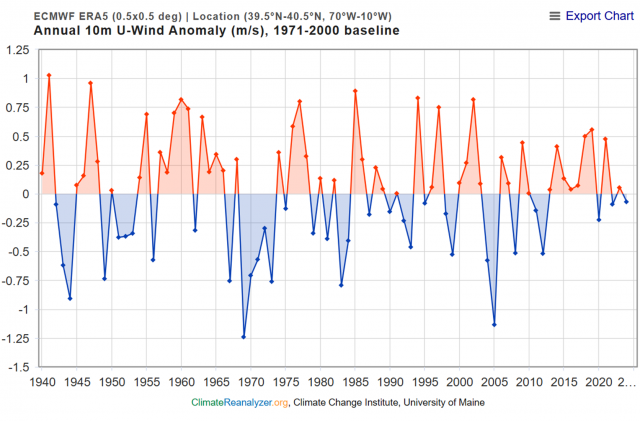
Charlie and others, Dr. Arthur Viterito responded to this paper by Trenberth et al. He doesn’t buy it. However, I feel like Dr. Viterito may be going a bit off on tangents and thus may be addressing items that are irrelevant or deceiving. He may also be misunderstanding what the paper is saying. I’d like to see what others think about this response: —————— So, one is led to believe that stronger winds are driving warmer and stronger currents in these narrow bands. Furthermore, that strengthening commenced in 2005 and has proceeded through 2023. If we examine the global zonal wind anomaly (surface) since 1940, we see the following: The global trend in zonal windspeed is slightly negative, not positive (Y=-0.0003X - .0067). The time series of zonal winds for the 40 degree North latitude band is depicted in the following graph: An important detail that must be noted is that Trenberth et al. used the 2000 through 2004 timeframe as their baseline. A baseline which is that short is very unusual as baselines of 30 years or more are the accepted norm in climate analysis. This questionable "baselining" of the data is, in my opinion, a serious flaw that can skew the results. I will adjust to a 30 baseline (1971-2000) and analyze off of that.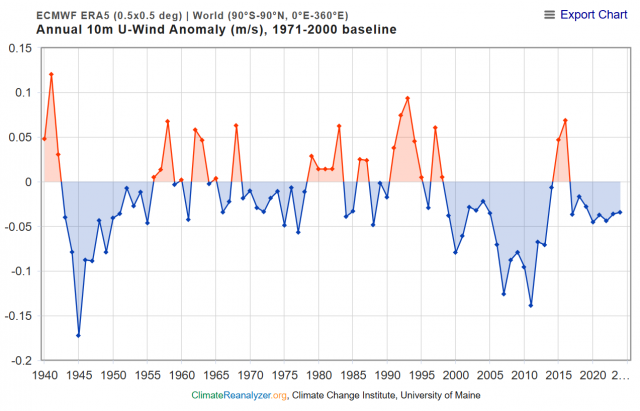
-
On geologic timeframes, I agree we're in the last act. It's no longer even possible to get a snowball scenario now, insolation is already too high. The drawdown in GHGs over the last ~300-500Mya has mostly neatly offset the increase in insolation over time but that parameter space is now limited on the downside. I would venture a guess that current continental drift resulting in another supercontinent+2-3% insolation puts temps well above Eocene levels and ends the golden age of habitability. In either the short or long run, if you pancake the ETP temp gradient with either GHGs or insolation, you kill off most marine life during the transition. If it happens quickly enough, then you can end up with Canfield oceans -- which I would describe as a weird form of undeath (purple water and green atmosphere from euxinic conditions). In the very short run, we're extremely close (450ppm) to tipping over in the Southern Ocean with regards to ocean acidification causing widespread aragonite undersaturation, what I would consider the first step in that process.
-
000 SXUS71 KILN 070651 RERDAY RECORD EVENT REPORT NATIONAL WEATHER SERVICE WILMINGTON OH 251 AM EDT WED MAY 07 2025 ...RECORD DAILY MAXIMUM RAINFALL SET AT DAYTON OH... A RECORD RAINFALL OF 1.16 INCHES WAS SET AT DAYTON OH YESTERDAY, TUESDAY, MAY 6, 2025. THIS BREAKS THE OLD DAILY SITE RECORD OF 0.91 INCHES SET IN 1971. $$ Only in the middle of the 1st week of May, but already have 3" of rain for the month already. No way May's going to be drier than normal by the time the month is over. Keep the stretch of wetter-than-normal months coming over the next several months, especially with some of the near-biblical rains, and we can forget having a summer this year.
-
I haven't been following the svr recently so looked at the SPC storm reports for May and its consistently 2-4 tor reports, typically some landspout in NM/TX and then a report or 2 somewhere on the eastern US side. The hail and wind reports range from 80-130 with an equal ratio. May 2 had a lot more. Snoozer!
-
Yeah the difference over the last 2 weeks is pretty amazing. These last few days finally got it wet below 10" down, I still had crumbly soil a foot down when I put in some bushes last week.


