All Activity
- Past hour
-
Milwaukee update Iowa-Dane-Jefferson-Waukesha-Milwaukee-Lafayette-Green-Rock- Walworth-Racine-Kenosha- Including the cities of Delavan, Mineral Point, Monroe, Kenosha, Whitewater, Brodhead, Shullsburg, Lake Geneva, Fort Atkinson, Muskego, Argyle, Blanchardville, Madison, East Troy, Belmont, Watertown, Janesville, Milwaukee, Darlington, Jefferson, Benton, Brookfield, Waukesha, New Berlin, Racine, Dodgeville, Beloit, Elkhorn, Barneveld, and Menomonee Falls 140 PM CDT Sat Mar 14 2026 ...WINTER STORM WATCH REMAINS IN EFFECT FROM SUNDAY AFTERNOON THROUGH MONDAY EVENING... * WHAT...Heavy mixed precipitation possible. Total snow accumulations between 4 and 7 inches and ice accumulations around a light glaze possible. Winds could gust as high as 50 mph.
-
MPX mentioned low ratios, in setups like these it’s what typically happens. Also it’s mid March not January.
-
They're still acclimating to daylight savings changeover.
-
Just saw it. Wow, going to be hard to sleep tonight if that’s what’s in store. Optimism growing. Top 10 or bust!
-
Maybe it changed today, but yesterday it looked kind of inverted.
-
Looks like MKE didn’t do a morning discussion.
-
Dumb question but why are the 12km and 3km NAM runs so different? Effectively different models in terms of how they process data? .
-
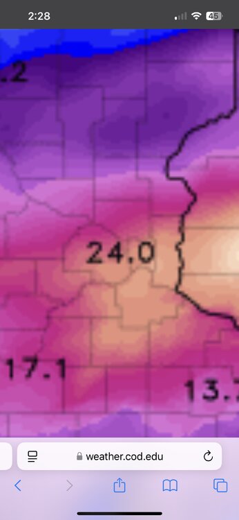
Hrrr has the bullseye over the heart of MSP. .
-
18z hrrr is one of the craziest things I’ve ever seen for us. Several hours of 2”+ rates, even pushing 3” for a while. The one thing that could really hamper our totals are the ratios. I wouldn’t be surprised if some of the ratios are under 10:1, maybe getting a bit better as the rates ease up but at that point the winds will ramp up and compact things too. .
-
I’d definitely feel better in your location versus mine. (Lake Nokomis - S. MPLS) Either way I’ve got cautious optimism in a metro wide 12-18” Starting to spit flakes here.
-
Dammit, you made me look!

-
WE need the rain so good news and with the snowpack gone less flooding risk.
-
HWW up out East. Congrats S Wey
-
This is perhaps a once-in-a-generation amount of blizzard warnings for March, in terms of area (not in Rockies)
-
I think I might actually end up in or close to the bullseye for the metro here in Blaine. Models keep bouncing back and forth a few miles and that’s enough to make a difference in the heaviest band. .
-
I was just looking into the 2021 Pacific NW heatwave recently; testing AI to see what it spit out regarding most extreme wx events and it was included. How sigmas and standard deviations come to be disseminated. The range is huge for a return rate but most certainly for events like the 2003 Euro heatwave, March 2012, and Jun 2021 they were 1 in 1000s of years magnitude using the current 30 year climate avg. If you use the pre-industrial climate benchmark (ice core sample data?) the 2021 heatwave might be a 1 in 150,000 year event!
-
Nice! Welcome! I’m a little nervous about the dry slot or mixing making its way into the southern half of the metro, but you’ve gotta be close to maximize the pivot. I think Anoka or Forest Lake is the place to be, but this should be fun regardless.
-

E PA/NJ/DE Spring 2026 Obs/Discussion
Newman replied to PhiEaglesfan712's topic in Philadelphia Region
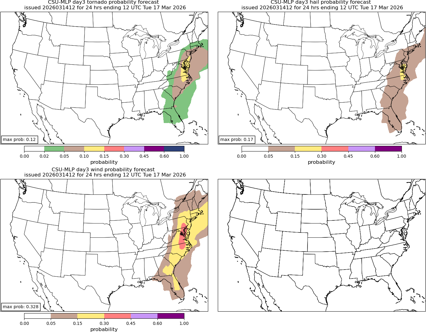
Posted this down in the Mid-Atlantic thread, but the CSU machine learning forecast is still looking ugly for Monday. I do believe the greatest tornado threat will remain *mostly* south and east of the Mason-Dixon, but a damaging QLCS is still nothing to scoff at. Embedded spin-ups a real possibility too. Will need to watch how the system evolves over the next 2 days as there is still a non-zero chance this evolves more into a discrete supercell type event for SE PA. New Day 3 SPC comes out in 30 min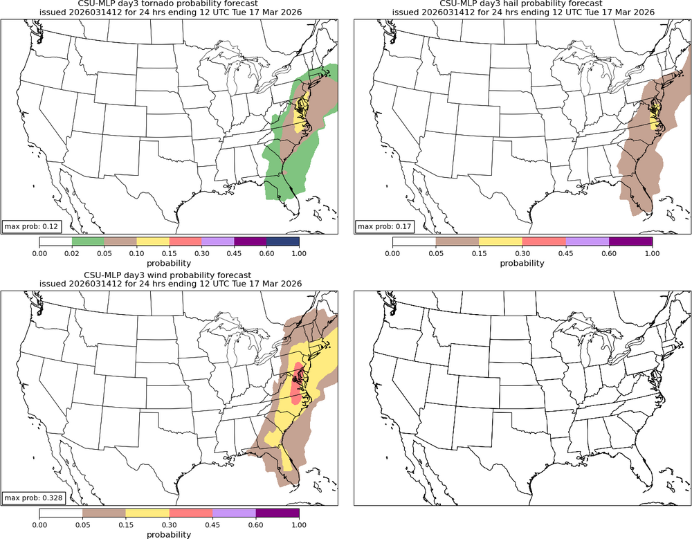
-
It's been having a moment
-
I am about to land at MSP so this will be fun ! Hoping for the best here.
-
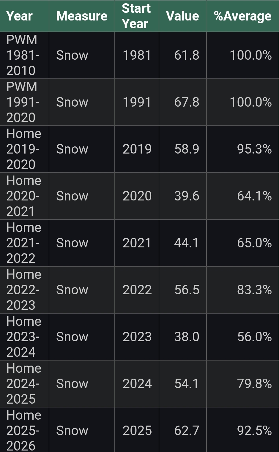
I used to think our locations were simpatico on being the relative BN screw-holes. Basically from you up the coast to PWM. I'm curious how you stand relative to your climo over the same stretch?
-
For the Midwest, depends how much blocking there is. AI isn't as aggressive with it as the OP Euro, but neither of them have had very stellar performances in the long range as of recent.
-
Afternoon AFD from LWX... @high risk i know you mentioned instability... LWX seems to be suggesting around 1K SBCAPE in the disco (bold mine) DISCUSSION... KEY MESSAGE 1...A strong cold front pushes across the forecast area Monday, bringing gusty winds and potential for severe thunderstorms capable of producing significant damaging winds and tornadoes. Precipitation chances begin increasing Sunday as a potent low pressure system traverses across the Great Lakes into Canada, pushing the associated fronts across the Mid-Atlantic. The associated warm front lifts through the area Sunday night with the cold front tracking across the region during the day Monday. Aloft, a robust trough digs across the central CONUS, becoming slightly negatively tilted as it approaches and pivots across the east coast Monday. This will push the aforementioned cold front across the forecast area, bringing impactful weather throughout the day. In the wake of the warm front lifting through Sunday night, high temperatures on Monday will be in the mid 60s to mid 70s. Additionally, with southerly flow, dewpoints rise into the upper 50s to low 60s across much of the forecast area ahead of the cold front. Storms may initiate Monday morning with any shower/storm capable of producing gusty winds due to a strong wind field aloft. Later Monday morning and into the afternoon, storms develop along the cold front as it moves through from west to east. Damaging winds are likely with severe storms capable of producing significant damaging wind and tornadoes. With such a strong wind field aloft, there is the potential for wind gusts of 70 to 80 mph within severe storms. Current model guidance shows 300-400 m2/s2 SRH and up to 1400 J/kg SBCAPE which is compatible with a tornado risk across the area. SPC has the forecast area along and east of the I-81 corridor in an enhanced risk for severe weather with the rest of the forecast area in a slight risk. PWATS will be seasonably high, although a fast storm motion limits the flooding risk.
-
GFS did quite a decent job at sniffing it out early, not too shabby at all.


.thumb.png.e28622a101ead8a503efd5015c7d3862.png)