All Activity
- Past hour
-
.96 heavy T storm overnight
-
93 yesterday at 4:10pm.
-

September 2025 OBS-Discussion centered NYC subforum
MANDA replied to wdrag's topic in New York City Metro
Had a pity total of .08". -
Only .20” here.
-
We picked up some much needed rain. .56” in the last couple days .12” is the total so far today. Dense fog this morning.
-
Dendy left the board
-
After this storm I see nothing in our extended forecast storm wise. Sent from my SM-G970U1 using Tapatalk
-
Looks like a soaker for southern Rhode Island into Southeast mass and the Cape this morning
-
Dews!
-
.75 in Westfield. 65 and some fog here in Simsbury
-
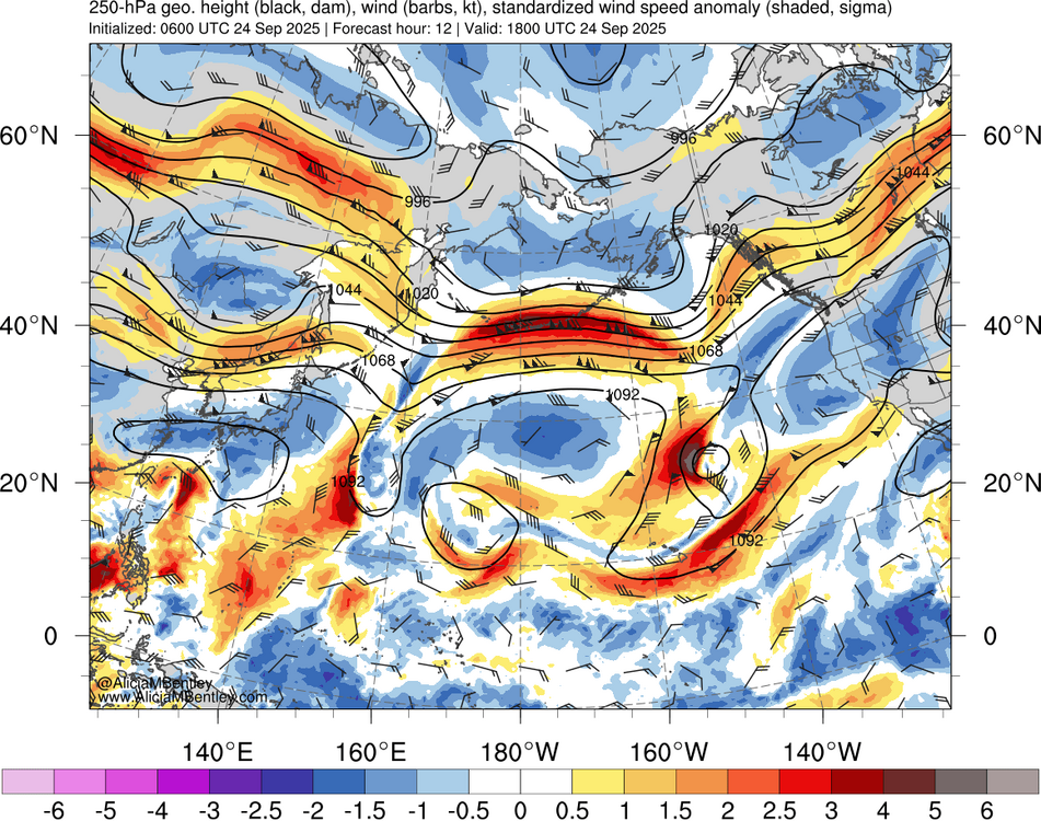
I think the record cold in Siberia creating the tight gradient between the record SSTs south of the Aleutians is helping this very strong shift to +EPO. This is following a similar pattern of recent years. Currently the Aleutians are experienceing a 4 sigma jet max helping to dig the +EPO trough and pump the warm ridge over North America. So as we have seen in recent years it tough to maintain a -EPO indefinitely. This EPO reversal was among the strongest we have seen from September into October. 4 sigma jet max near Aleutians Strong EPO reversal https://downloads.psl.noaa.gov/Public/map/teleconnections/epo.reanalysis.t10trunc.1948-present.txt 025 09 01 -195.59 2025 09 02 -217.86 2025 09 03 -189.23 2025 09 04 -134.91 2025 09 05 -108.24 2025 09 06 -90.21 2025 09 07 -71.66 2025 09 08 -37.71 2025 09 09 3.25 2025 09 10 39.61 2025 09 11 71.15 2025 09 12 90.96 2025 09 13 97.24 2025 09 14 92.25 2025 09 15 53.53 2025 09 16 -6.59 2025 09 17 -20.75 2025 09 18 -29.60 2025 09 19 33.92 2025 09 20 133.17 2025 09 21 158.66
-
0z euro is fun lol
-
0.30” from last night shower
-
Wet. Around 0.50”. Bangers in there.
-
about an inch here, 66/66 and foggy
-

September 2025 OBS-Discussion centered NYC subforum
bluewave replied to wdrag's topic in New York City Metro
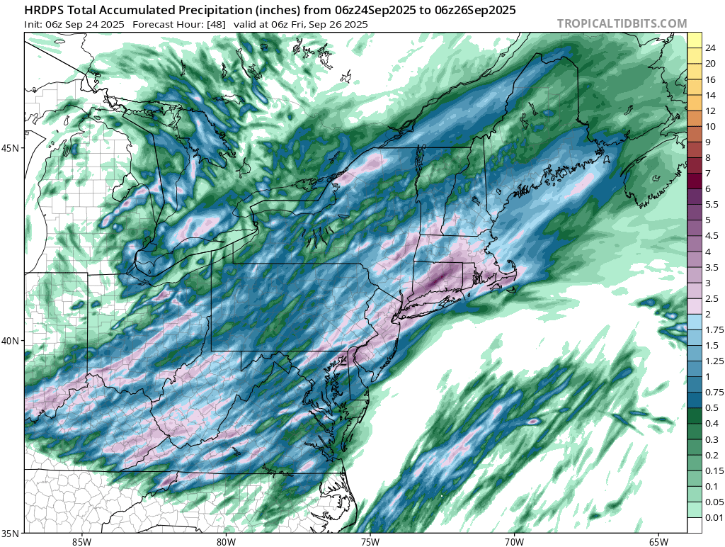
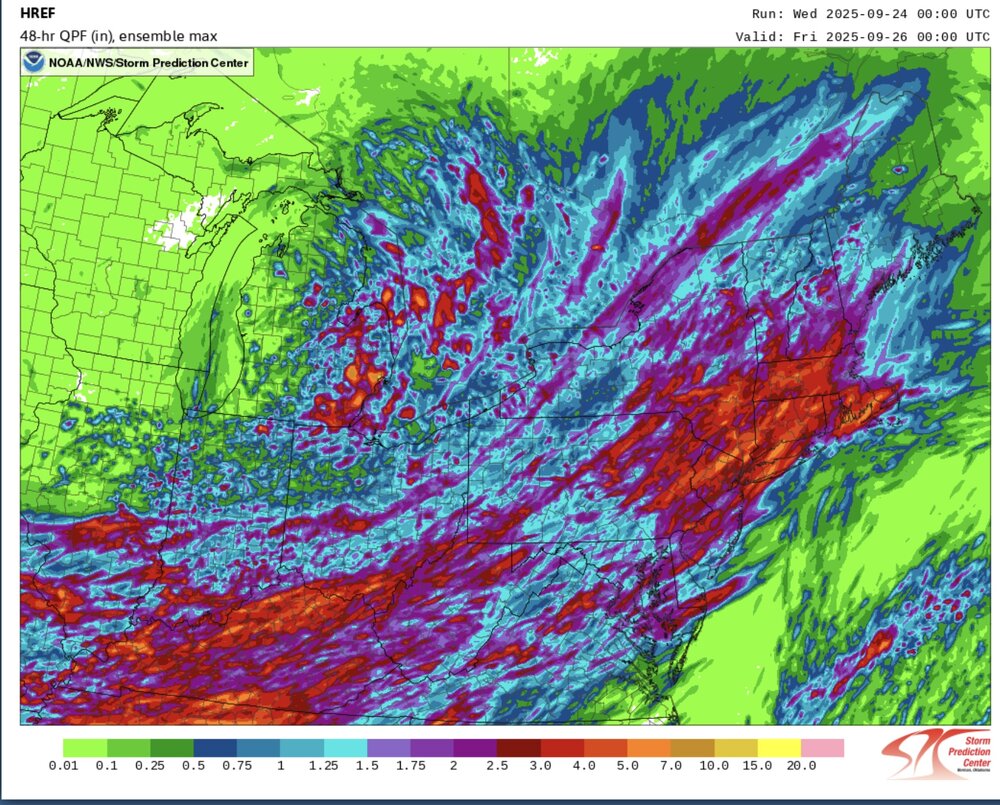
This looks like our best rainfall potential in a while. Good signal from the CAMs for a widespread 1.5”+ with pockets of 3”+ possible. Just had brief heavy downpour here.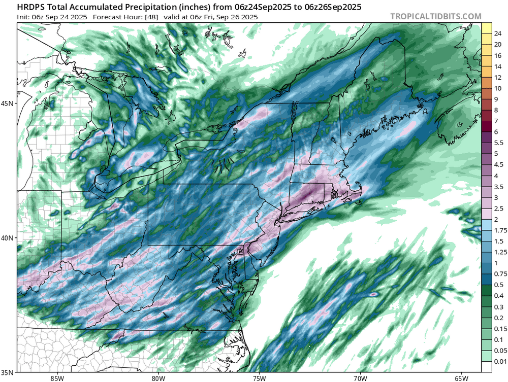
-
How did things turn out?
- Today
-
@Gawx Starting to wonder if we are seeing a secondary peak in this solar cycle
-
0.16 overnight and 2.17 for the month. Looking like another inch before all is said and done. Not as dry as imagined.
-
.18" overnight 64/65
-

Central PA Summer 2025
Mount Joy Snowman replied to Voyager's topic in Upstate New York/Pennsylvania
Low of 63 with dense fog and a whopping 1.97” of rain. -
0.25” overnight. We wait
-

September 2025 OBS-Discussion centered NYC subforum
donsutherland1 replied to wdrag's topic in New York City Metro
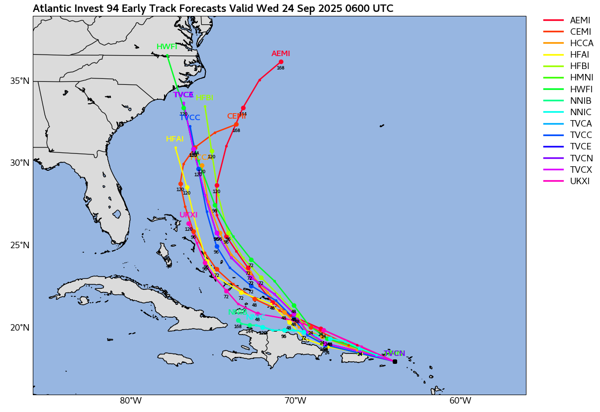
The early guidance on Invest 94 now shows a cluster of solutions indicating that the system could be approaching North Carolina in five days. Much can still change, as five day forecasts are subject to large errors. A near miss or out-to-sea solution remains viable.
-
Lightning and thunder for hours overnight .79
-
Very good call. It also looks dry as a bone which obviously is not good at all given the ongoing drought since the end of July


.thumb.png.4150b06c63a21f61052e47a612bf1818.png)