All Activity
- Past hour
-
We’ve had some nasty stretches, but I never saw this week as crap. I’d argue yesterday was better here than today lol.
-
It has been muggy! My standing joke is: if you want a sweater for Christmas, I'm your guy! 5.35 inches of rain this month in Pleasant Gardens. 26.57 for the year.
-
Tomer Burg has been all over the EPS & Euro being too hot in the extended, see below tweet:
-
Landscaping now with Gatorade in hand. Today if you are outside working you needs extra hydration and electrolytes.
-
Likely some certainly helping but I think they've also been along an instability gradient and there have been subtle vorts moving through
-
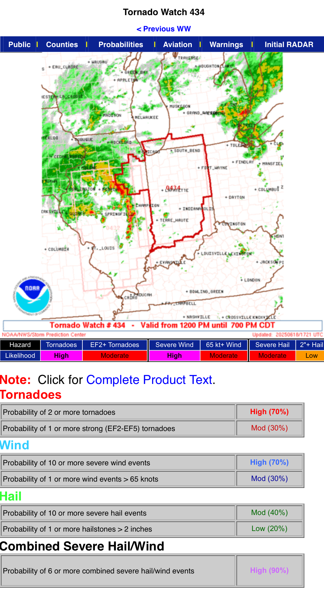
Nice probs on the new Tornado Watch.
-
The VIL on that severe warned storm is big time
-
Sunny as can be and muggy here Got the feeling
-
Not a drop here yet loud thunder
-
This will likely be another case of a strengthening hurricane til landfall. A Cat 4 at LF wouldn't surprise me.
-
Tornado possible near Detroit
-
Yeah, all that ...and, I'm personally suspect that these global model '2-meter temp' depictions are not in fact the actual 2-meter temperatures, but are really just stopping the adiabats at 1000 mb level and taking whatever it calculates at that sigma level. Pretty sure they lack the resolution in that lowest 20 someodd mb of the floor ... where the 2-meter slope temperature really is. It can be 95 at the top of downtown church steeples and 101 on the sidewalk going by.... Although, in the winter, they do better ... but then in the winter the sounding is pretty uniform ( typically..) in the lower 100mb
-
Steady rain here again with some nice rolling thunder.
-
Btw I meant to ask but what is going on the last few days with the outlook area between SE PA and DE and NJ? They’ve been in a tiny marginal area the last few days. (And seems to have been producing too!) Some kind of orographic or local phenomena going on?
-
I’d come down to chase!
- 1,049 replies
-
- 1
-

-
- severe
- thunderstorms
- (and 2 more)
-
Wow this is bad -- nearly an inch in about 15 minutes and more incoming from the west. Unlike most t-storms it stayed real steamy out. Back neighbors' yards look like a creek
-

2025 summer max contest -- enter by 06z June 20
GramaxRefugee replied to Roger Smith's topic in Mid Atlantic
DCA: 100 IAD: 101 BWI: 102 RIC: 101 -
Correlation coefficient shows it’s on the ground. Looks like it may have clipped the west side of Jacksonville before going toward the airport.
-
Looks like a nice shot for the area between 6-8 PM tonight
-
Extrapolated pressure now at 972.5mb, with FL peak of 93kt and SFMR of 88kt. Not bad.
-
the radar shows one, or two, areas of rotation. it's a tornado. It's the same radar, different tilt
-
Yeah looks like everything clears the area by 5PM
-
That escalated quickly. Had a long phone call and was going to do a little yard work and suddenly it's POURING and radar is lit up. I thought this would be later Now a FF watch and severe TS watch dang!
-
I wouldn't focus on model 2m output this far out...outside of looking at it for fun. As always, there are going to be several factors which are going to determine exactly how high temperatures get and these are more for the mesoscale time frame. If anything is going to hinder us it will end up being high clouds passing through. This would be something MOS won't pick up so as we get closer if MOS has 101 or 102's...better be checking potential for high clouds and what MOS has for dews and whether it looks overmixed
-
If we ever get a 60% wind for us I will promptly perish.
- 1,049 replies
-
- 2
-

-
- severe
- thunderstorms
- (and 2 more)