All Activity
- Past hour
-
low of 52
-
53/51
-
They might sneak a 32F in there. Pretty crazy how it just keeps radiating. We fogged out at 45F and just keep sitting 41-45F in the valley. 42F min at nearby PWS. It’s in the 50s like 500ft overhead lol.
-
At this rate, the way it's trending, it will snow in October.
-
34F here. Fall is coming...
-
45F on the home Davis, great morning for a walk.
-
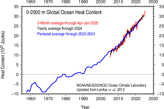
Ocean heat content in the 0-2000m layer has jumped up this year, recovering from a nino-related dip. A sign that warming at a fast clip continues.
-
6hr min at HIE will be interesting…
-
Beautiful AM. 47F
-
42.7° Coldest since June
-
I agree. The Niña is tipping its hand much earlier this year than last, there’s a -IOD event now and the NW Pacific is even warmer. There’s also a very pronounced -PMM and we have a deep -AAM, whereas last year was very +AAM/Nino like. Last year by this time we had a parade of recurving tropical and extratropical storms training over the inferno SSTS off Japan cooling/upwelling them, not happening this time around. In fact the -PDO is even stronger now with SSTS of 11 degrees F above normal in that area….that’s staggering. And obvious big changes in the Atlantic with the big persistent cold pool south of Greenland and up Davis Straight
- Today
-
 September DCA _ NYC _ BOS ___ ORD _ ATL _ IAH ___ DEN _ PHX _ SEA 1.5 1.0 1.0 1.0 1.5 1.5 1.0 1.5 0.5
 -
 Fall is in the air here this morning, currently 43F here in the Berkshires. It's 55F back in HPN.
 -
High of 78.6 yesterday. Currently 59
-
Down to a fantastic 45F here in E CT, great fall feel heading to Labor Day and Fair season!
-
Eastern Tropical Atlantic:A tropical wave is forecast to emerge off the west coast of Africa by this weekend to the south of the Cabo Verde Islands. Thereafter, environmental conditions appear favorable for some slow development of this system as it moves westward to west-northwestward at 15 to 20 mph, moving across the eastern into central Tropical Atlantic through the middle of next week.* Formation chance through 48 hours...low...near 0 percent.* Formation chance through 7 days...low...20 percent.
-

2025-2026 ENSO
so_whats_happening replied to 40/70 Benchmark's topic in Weather Forecasting and Discussion
Also wanted to post the latest for July and August via TAO on the subsurface look between 2N and 2S..thumb.gif.62b3ab872b6d52afd701d41cc007a7bf.gif)
-
I know several consider last winter to be a top analog, but there really has been a lot of change in the SSTA pattern in just about every basin. The observed pattern also feels very different. We had a high of just 70 F today in Tulsa for the 5th coldest on record, which is on top of a cool and extremely wet summer...very different from last year at least at this juncture.
-
2025-2026 ENSO
so_whats_happening replied to 40/70 Benchmark's topic in Weather Forecasting and Discussion
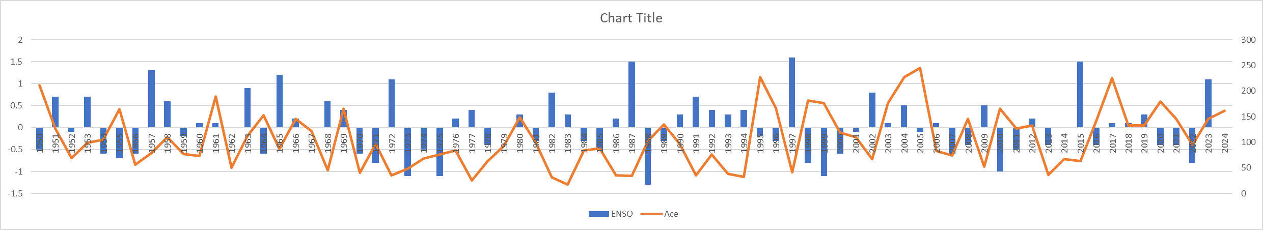
Did a very quick rather busy chart on excel. Basically it is the JJA ENSO data from CPC in blue and Ace numbers for the season in orange. Now this doesn't help explain where we came from like previous winter may have been Strong Nino and we crashed to weak nina by summer as an example which could play a role. This is for every year from 1950 to 2024. Edit: Had to fix it so you could see every year. Shame it does not have dots for Ace to see the years better.
-
 Down to 56. Can’t remember an August with so many 50s.
 -
 Your initial comment was correct. I work up a big sweat when I run in 35 degrees. If you're actually running instead of walking and it's an extended period of time, you're going to sweat profusely no matter what the temperature is. Anyway today was spectacular weather. It felt extremely comfortable with a high temp of 77 here.
 -
Though support has waned significantly since all but the GFS had it on Monday, the 0Z UKMET brought the E MDR AEW back from the dead (albeit with later TCG) with a minimal TS due to a strong pressure gradient below a rather strong Azores high moving WNW: NEW TROPICAL CYCLONE FORECAST TO DEVELOP AFTER 156 HOURS FORECAST POSITION AT T+156 : 15.6N 33.8W LEAD CENTRAL MAXIMUM WIND VERIFYING TIME TIME POSITION PRESSURE (MB) SPEED (KNOTS) -------------- ---- -------- ------------- ------------- 1200UTC 03.09.2025 156 15.6N 33.8W 1010 34 0000UTC 04.09.2025 168 16.9N 35.9W 1011 35 ——- But 0Z GFS/Icon and probably CMC have nothing.
-
Meanwhile, .15" on the day and that's the best day of this pitiful week
-
-Indeed, only 11 of 15 La Niña seasons (I’m including 2024) since 1995 had well AN active era ACE though that’s still near 3/4 of them. -For neutral: only 1/3 had well AN active ACE -For El Niño: only 2/9 had well AN ACE -So, La Niña has been associated with the highest odds by far of a high ACE season


.gif.0189dd4b12ebe985883091371d289dfa.gif)