All Activity
- Past hour
-
Ahead of the current system (Winter Storm Ezra) I cored the snowpack here at our site in association with yesterday morning’s CoCoRaHS report, and the 1.63” of liquid measured was within a few tenths of the projected snowpack water content based on NOHRSC modeling. The modeling also suggested that Winter Storm Ezra could be quite a snowpack boost around here, even in the valleys, with another inch of liquid equivalent being added. Comparing the modeling from yesterday with that of today, it looks like the updated projection for snowpack depth increase is probably a bit more realistic, but both estimates stick with about an inch of liquid going into the snowpack. We had 0.81” of liquid equivalent recorded from the storm as of this morning, with a bit more falling today, so those liquid estimates seem to be in the range of what we’re getting. The mountain snowpack should certainly get a solid injection of liquid equivalent out of this event. Now we’ll just need a decent amount of new snow on top of the snowpack to get the surface conditions back in good shape, but the BTV NWS forecast discussion says snow showers should be continuing throughout the week.
-

January 2026 regional war/obs/disco thread
SouthCoastMA replied to Baroclinic Zone's topic in New England
Feb 06 was about 10-11" of Arctic sand here. not my favorite storm, though Id take it now in a hearbeat -
Rgem
-

E PA/NJ/DE Winter 2025-26 Obs/Discussion
LVblizzard replied to LVblizzard's topic in Philadelphia Region
CAD really working its magic keeping temps in the low 40s rather than near 50. Looks like that ice on my sidewalk and driveway will be sticking around for awhile. -
definitely since Jan 7th 2022. We had 2-4"/hr rates that storm. I got 4.2" in one hour. Huge dendrites and zero wind will do that.
-

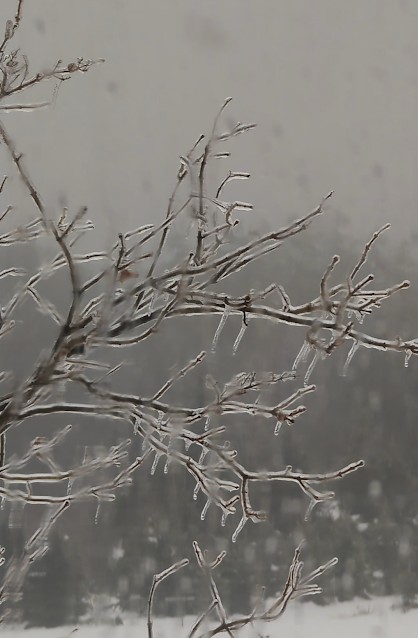
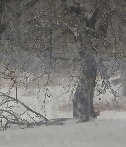
Ice Ice Baby December 28-29 Storm Discussion
wx2fish replied to Baroclinic Zone's topic in New England
Hanging tough down here. Maybe we erode it some down here ahead of the front, but its gonna be a grind. 3k and hrrr keep MHT in the mid 30s now. Maybe we get a quick pop to 40 along the front. -
06z Euro tries to give some light snow north of I-66 on New Years' Day. Wouldn't be much, a coating to one inch at most, but it would be great to get something.
-
you guys are dumb
-

Ice Ice Baby December 28-29 Storm Discussion
wokeupthisam replied to Baroclinic Zone's topic in New England
Same story here with the gutters, iced over the guards so its like they aren't even there. Lost a branch off ye olde apple tree, hoping for warmth later before it refreezes and winds get gusty.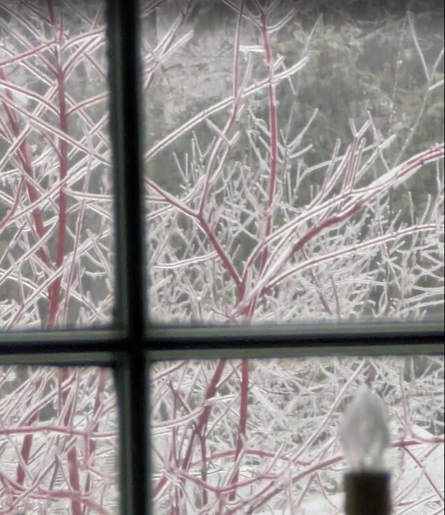
-
Sounds like a normal transitional period where models struggle while weenies use every change as a reason to cliff dive. I guess this really is everyone's first winter on these boards
-
what in the doom and gloom did i wake up to?
-
I'm in Staten Island (Willowbrook)
-
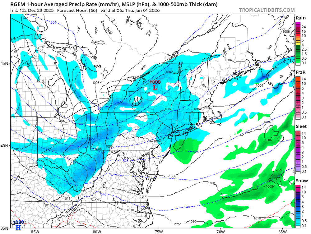
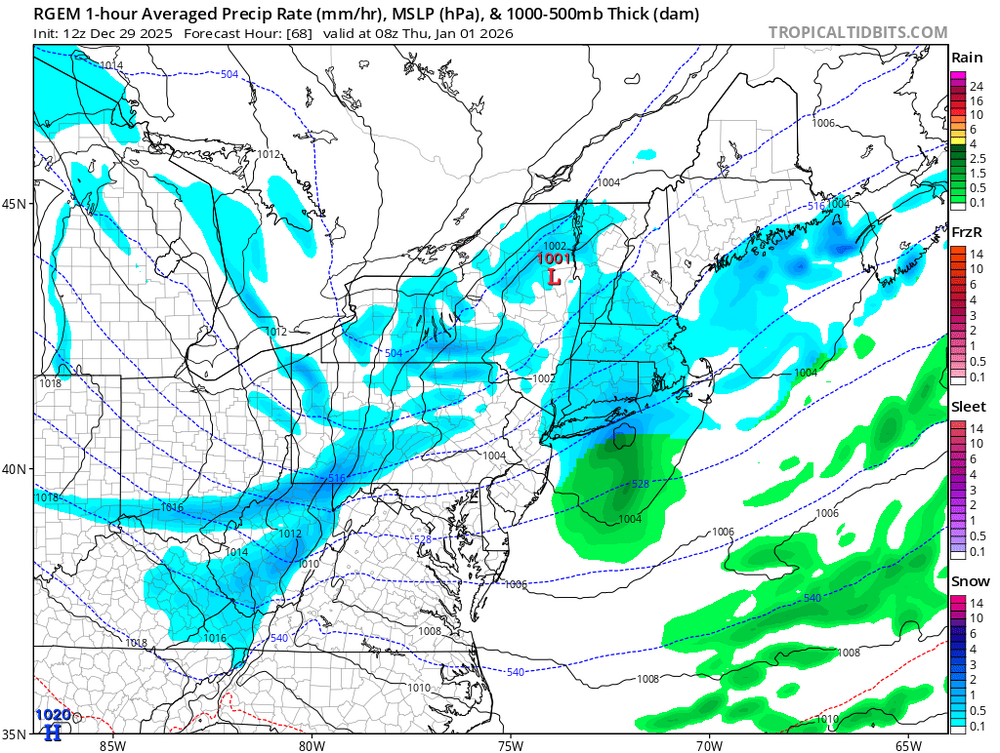
I'd still watch NYE with the FROPA, the RGEM shows what can and has happened before with those setups, a small surface low forming off the coast on the front and some areas, especially S and E portions can see accumulating snow
-
-

Ice Ice Baby December 28-29 Storm Discussion
Baroclinic Zone replied to Baroclinic Zone's topic in New England
45/42 little snow left at this point. -

Ice Ice Baby December 28-29 Storm Discussion
wxeyeNH replied to Baroclinic Zone's topic in New England
32.2F here also. I did briefly get up to 32.5F We have to get this ice off the trees and surfaces before this evening or we are screwed. -

Ice Ice Baby December 28-29 Storm Discussion
dendrite replied to Baroclinic Zone's topic in New England
Yeah I forgot to put mine out after melting down the inch of snow the other day. I got it out there at 1230am after it had already started pouring. It hasn’t budged from 32.3-32.4 here for over an hour. The gutters froze up so I have water pouring over them and water getting into parts of the basement. Hopefully we can get into the upper 30s for a bit so the driveway can melt out otherwise it’ll be unwalkable for awhile. -
World’s apart is an understatement lol One of them is going to be dead wrong. @bluewave @donsutherland1 Any thoughts on this?
-
2.0" snow then light freezing rain. Probably cold rain this afternoon, as the CAD underperformed the forecast. Yesterday's temp was 30/-11, the rare winter 40+ range day without a strong CF/WF.
-
Your numbers are slightly off since you didn't include the final 18z NAM total. "Newark" was 0.8, NYC was 2.6, Bridgeport was 5.8, and Islip was 5.0". Just a few additional tenths, but it matters. I suspect the annotated value for EWR is wrong. Since Newark is north of Staten Island, that should definitely be above 1" and likely close to the value for MMU. Is it even known where Pivotal pulls these values from? The 18z HRRR was obviously way off across our area. It's way too snowy in NJ and PA and it lacks the gradient that was observed across the LHV and Long Island. Any analysis showing that it performed better than the 18z NAM across this area is seriously flawed.
-
Feel familiar?
-

Ice Ice Baby December 28-29 Storm Discussion
AstronomyEnjoyer replied to Baroclinic Zone's topic in New England
Certainly no lack of QPF with this thing, least around here. I was bad and didn't thaw out my stratus, so it already had about 0.40" in it before this event, but there looks to be about 1.7" total in there now. So, roughly 1.3" from this event so far. And the radar still looks pretty healthy. Rotting at 32.2°. -
I had one freeze and burst open so water was pooling underground along the foundation and seeping through So last week I did a serious bush fix and put a 25 foot flex hose to get the water away from the house. It's finally drying but it looks like I have some work to do in the spring.
-
Eh, the plows up there are amazing - not sure you'd be OK in a Mustang, but pretty much anything else you'd make it. There is an extra bedroom in the Airbnb. Pack your laptop (I am) and c'mon up - dead serious. 5 feet of snow, temps not rising above 20 for the duration and absolutely no worries about whether or not you'll get a half-inch in downtown DC in a 10 day "fantasy" run My kinda winter.
-
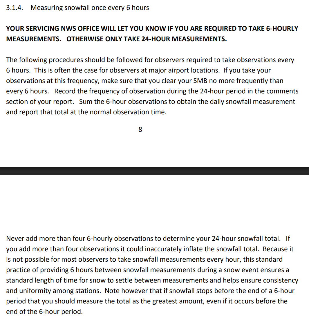
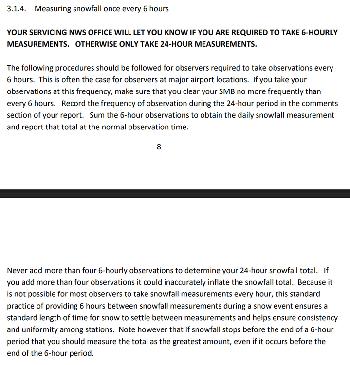
Is the 6 hour measuring guideline completely phased out now and no one uses it anymore? I typically only measure the depth at the end, unless its a long duration snowfall event or ptype changes over. This is from a PDF for snow measuring guidelines for NWS COOP from 2014.


.thumb.JPG.418e8a9a2902ae687ec35ff4bc0e038e.JPG)