All Activity
- Past hour
-
Define "here".
-

December 2025 regional war/obs/disco thread
Torch Tiger replied to Torch Tiger's topic in New England
hoping for a very strong cutter with a trackable fine-line. Santa? -
-
Something tells me this post will not age well.
-
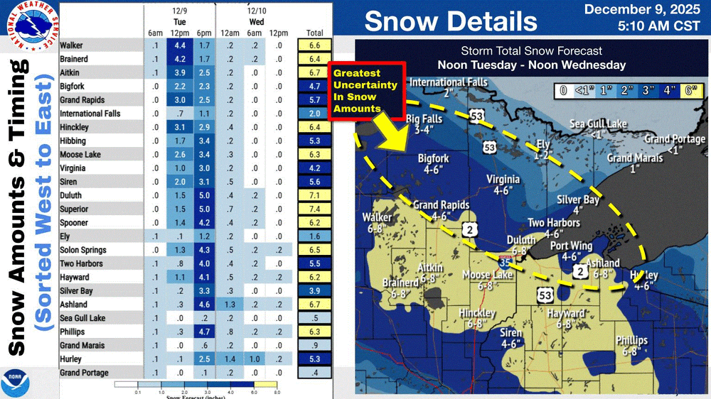
Totally got robbed on this one. NADA! Even Duluth only got 1-3". Talk about a S trend. That's OK, still early in the season.
-

December 2025 regional war/obs/disco thread
HoarfrostHubb replied to Torch Tiger's topic in New England
Just realized my daughter is under a winter storm warning in S VT... wheee!!! -
I started a lame thread for Friday lol.
-
Since the long range thread is starting to get jumbled with rumors or torchmas and multiple possible small events. I decided to start a thread. Will the lowlands score while nw continues it drought? Let's talk about it here.
-
I'm most "worried" about another miss south for Friday right now - pretty much all the models stick with the seasonal trend. Not gonna cry over missing 1", at least.
-
stuff like this pisses me off to no end. monday night it showed 28 for a high on christmast with a chance of light snow on long range. Now it shows a torch of course. I bet that is accurate vs the cold it just showed
-
I drove my 92 tempo up hill both ways to campus back then
-
1. No teleconnection even comes close to guaranteeing anything. But most have notable tendencies that make them helpful for forecasting. They’re useful tools, including the MJO, but they’re not crystal balls as the atmosphere is much too complicated for any one index to be reliable. I’d argue the MJO is about as good a tool as any of them. 2. I recently did an analysis of 3+ day long Dec phase 8 at RDU and found a whopping 78% of them to have been colder than normal: # of periods: MB 5 (22%), B 13 (57%), NN 0 (0%), A 2 (9%), MA 3 (13%) So, there have been nearly 4 times as many B/MB periods as A/MA periods at RDU for Dec phase 8 periods lasting at least 3 days. 3. Regardless, of what may come and in what phase, what about prior to that period? The period 12/3-16, most of which is forecasted to be in phase 8, is forecasted to end up with all colder than normal days at RDU and in much of the SE and to be at least in the top 5 cold for that period of the last 50 years! That would be 90 percentile cold.
-
Add Syracuse to that list. What an great start for them.
-
Can't believe all the complaining here and some folks saying we will never have a return to several above average snowfall seasons in a row here - - once again look at this history of NYC snowfall and try to explain it - we will return to above average snowfall seasons soon enough - its just that some of you younger folks have been spoiled by all of the much above average seasons since 2000........without a long stretch of much below normal seasons monthlyseasonalsnowfall.pdf
-
Pittsburgh/Western PA WINTER ‘25/‘26
TheClimateChanger replied to Burghblizz's topic in Upstate New York/Pennsylvania
-
December 2025 regional war/obs/disco thread
Snowcrazed71 replied to Torch Tiger's topic in New England
Lol.. for those of us who can "weather" the storm (so to speak), grab your popcorn and enjoy the show. We'll be back to our regular scheduled program after Christmas. -

Central PA Winter 25/26 Discussion and Obs
Mount Joy Snowman replied to MAG5035's topic in Upstate New York/Pennsylvania
So sure enough, as soon as I got on the train in Mount Joy this morning some light mix started falling. Can any of my Lancaster peeps confirm that there was a period of very light wintry precip this morning? -
December 2025 regional war/obs/disco thread
Great Snow 1717 replied to Torch Tiger's topic in New England
Oh I have noticed lol -
Totals mostly in the 4-6” range, even to our north. I think this is mostly because ratios were around 9:1 according to MPX. If we were in the 12:1 or 15:1 range we would have seen some of those higher totals verify. I think there ended up being a much bigger lull after that initial wave than the models showed. .
-
-

December 2025 regional war/obs/disco thread
SouthCoastMA replied to Torch Tiger's topic in New England
If you haven't noticed, that has already started and may peak well before Christmas. -
-
You’re not the only one
-
Finally above freezing, just in time for any precip. Funny how precip chasing warm always works out. 37F
-
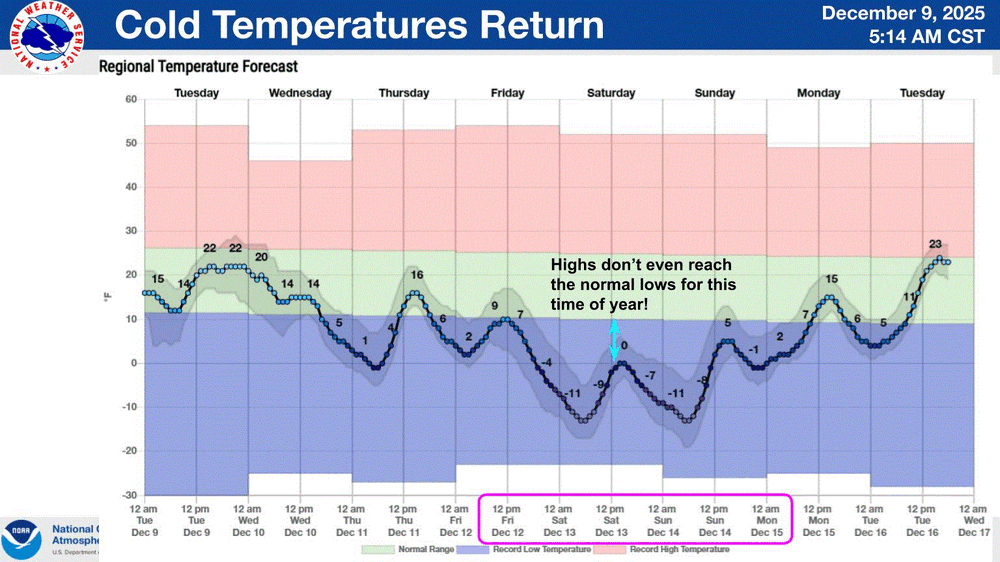
We closed twice last year for cold, but never had enough snow to close for that





.thumb.png.f89609abbea0f7e45ed3d38c0ae475d9.png)

.thumb.jpg.ad3a2e31d30aff035044689b311a0540.jpg)