All Activity
- Past hour
-
July 2010 too.
-
much better than foggy and not being able to see outside
-
*usual warm spots* doesn't cut it Chris, if the entire region doesn't hit 100+ it's not historic
-
even during Sandy? wow
-
Nice! Hope it works out for you!
-
I'm expecting 2-3 deg machine number cool bias Fri/Sat, too. Back side attenuated cool advection becomes mainly a DP evac, leaving the region with W-NW d-slope with still +14 850s has super adiabatic expansion ...blah blah... I bet it's 80+ Thurs.. MEX is already doing 86 Sat at KBDL-KFIT-KASH Frid.... this should translated into town no problem in that synoptic. I bet those are nine-os In fact, we may materialize the heat wave beginning Sat -->
-
If you select a spot away from the metros, it looks more reasonable (Reston 99 on GFS, 102 on Euro). The models got too good and are projecting the tarmac temps
-
It would be interesting to see the 500MB charts from (Jul 15-20) 2013 and (Jul 16 - 24) 2011 to compare vs the forecasted ridge as well as 2024 (June). Jun 7-10 had some strong heat as well for if talking June specific.
-
yeah hot run
-
69° / 62 dew point. Feeling a little warm already. I can imagine how I will feel next week.
-
-
Seven days w/o measurable precip - last time that happened here was in January. June average rain is 5.11" (2nd only to OCT) but we're on a 2.5" pace so far. The month has often been tough on the garden, either a washout like 1998, 2009, 2023 or sun-baked Stein like 2004 and 2021. With 2 weeks left, June 2025 hasn't landed in either extreme - yet.
-
Already had two showers blow thru this am, but still under .10 total. Boy is it miserably muggy. Currently 72.2/70.0, feels like a sauna out there.
-
Meanwhile 96 hours of sub 70 a mighty task for June 66 here.
-
Yeah I have my second to last tournament up in Churchville this weekend... so far we have been able to get every tournament in this year. Next weekend's EOY tournament is at the beach.
-
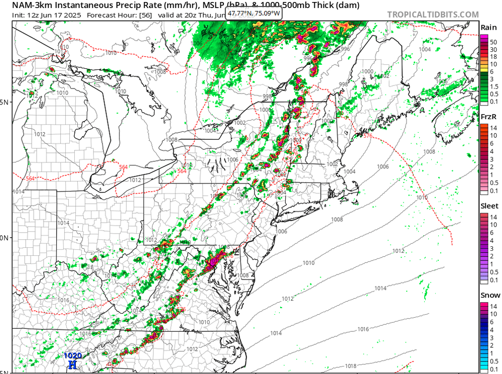
Thursday's severe threat seems decent especially near/west of I-91. Mid-level lapse rates are fairly steep plus decent low and deep layer shear.
-
Hot spot. Over the last 20 years, the BDL average for year's hottest is 98.2. 15 years reached 97 or hotter, though only 5 set a year's hottest before July 1.
-
Summer softball starts tomorrow. Need some sun to dry out soggy infields
-

New England 2025 Warm Season Banter
backedgeapproaching replied to bristolri_wx's topic in New England
Yea, I saw that..oof. I took mine apart as much as I could and did a bleach cleaning and let it dry. I think every window AC prob has some type of issue with water and some mold, but yea looks like a design flaw. -
I never lost power at my home in little ferry. It surged all night but never went out. Was odd being one of the few houses in the area with full power...and A/C!
-
Let's break the power grid. 105+
-
Much of central PA is now under a moderate risk of excessive rainfall today. CTP highlighting the area for "Dangerous Flooding."
-
We live on an island surrounded by water…
-
Yeah I’m selling on 104-106. 100 though seems possible
-
This looks fun for Thursday....
- 1,042 replies
-
- 1
-

-
- severe
- thunderstorms
- (and 2 more)


