All Activity
- Past hour
-

-
I'm down here in Maryland. My home page is the Mid Atlantic. I'm moving up to the Tug Hill for the winter on Dec 1. I'll be just south of Barnes Corner. I'm going to be chasing blizzards and observing intense lake effect snow bands. Is their a specific group/subforum dedicated to lake effect? I'm looking forward to joining you fokes this winter. I'm ready to chase some supercharged Nino monsters this winter.
-
This is an excellent read on the area of extreme wind observed around Pensacola https://x.com/bevinswx/status/2109425113624150145?s=46&t=NyKvXvI1o-sJQb-68mmo4g
-
 canadian drugstore online: Can Get Rx - the canadian pharmacy
 -
-

2026-2027 Record-breaking El Nino
bluewave replied to Stormchaserchuck1's topic in Weather Forecasting and Discussion
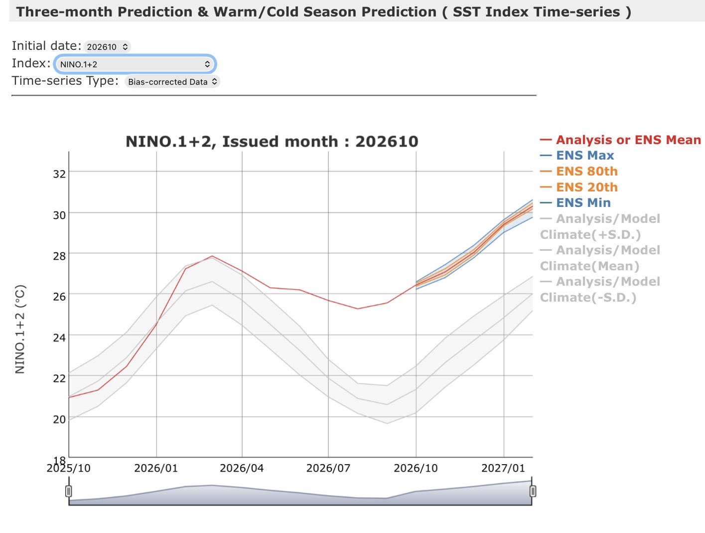
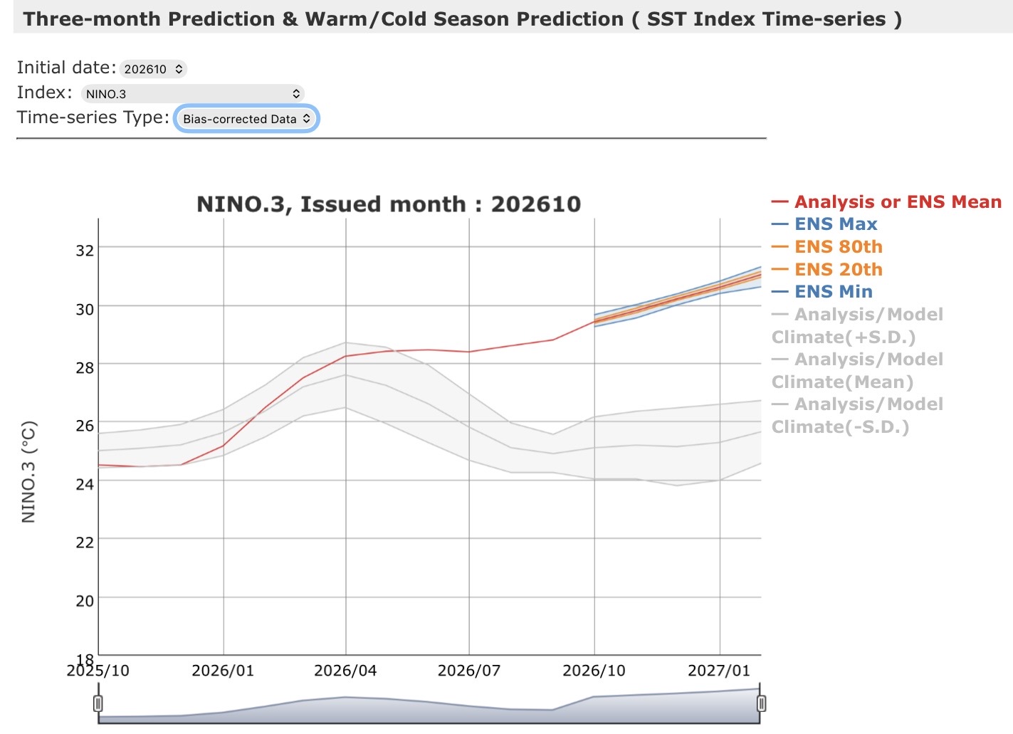
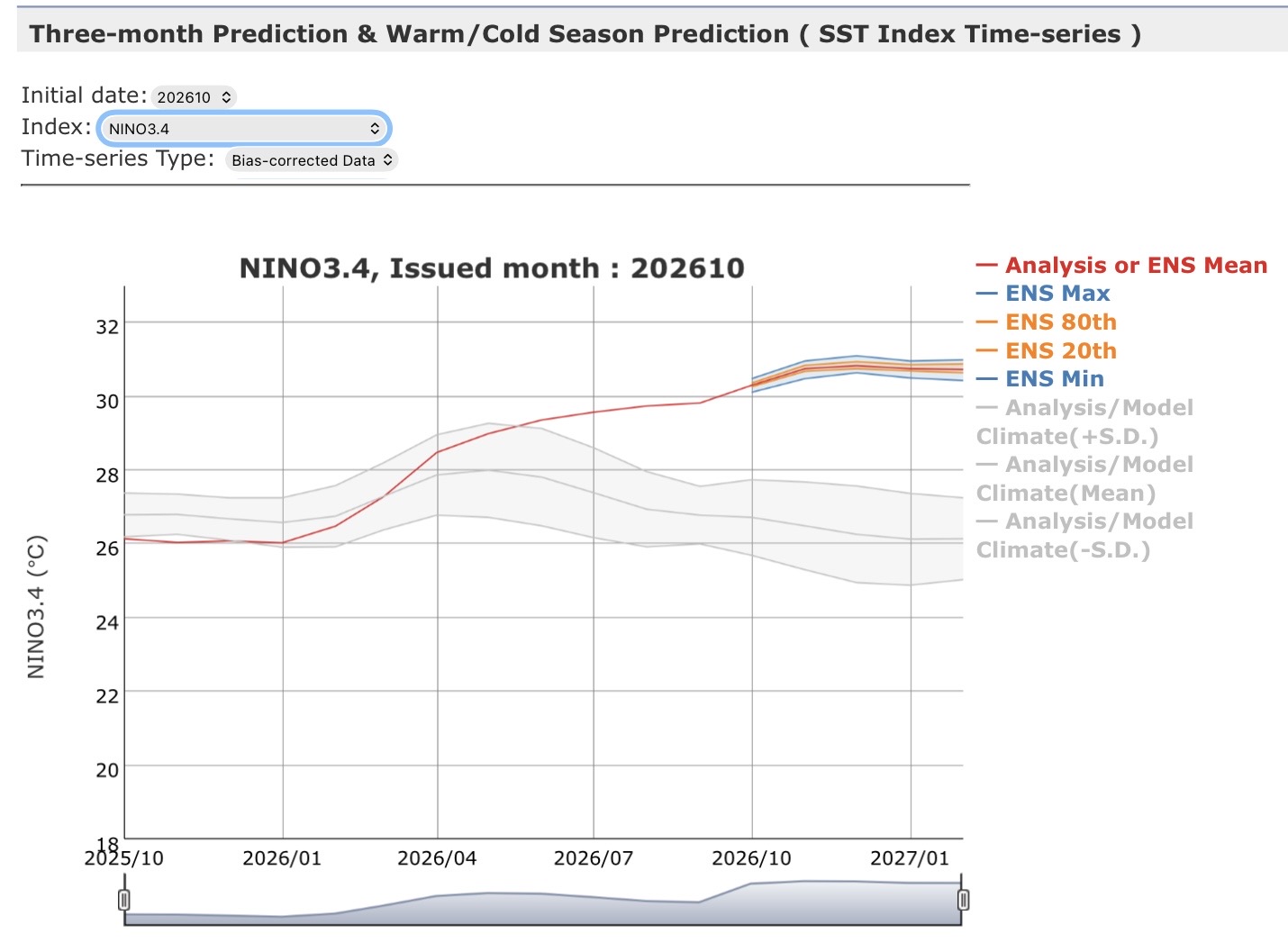
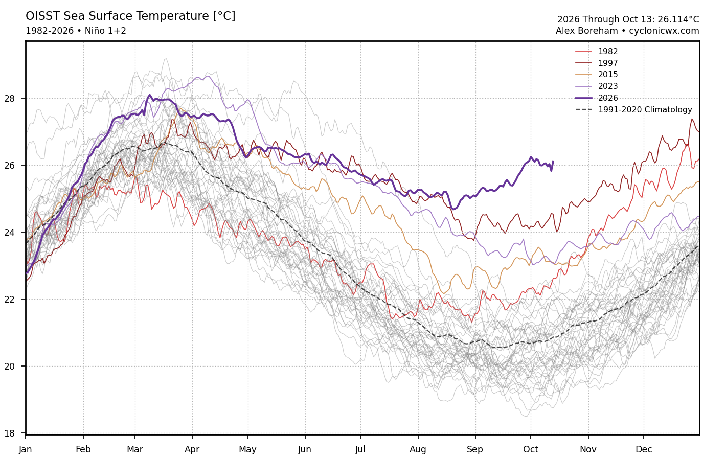
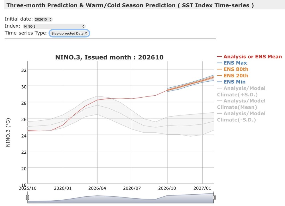
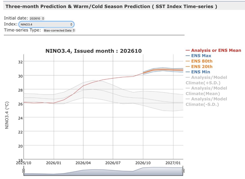
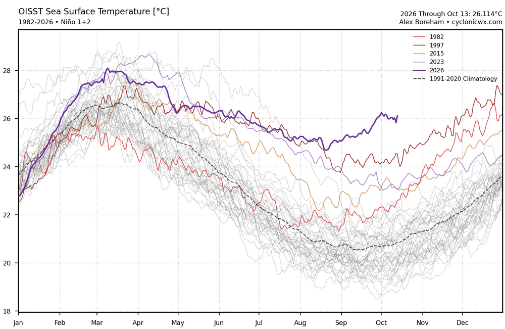
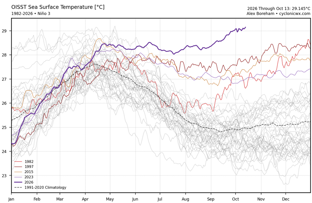
It’s great that the JMA has a chart showing the actual forecast SSTs. The current run now has the potential of the +30C warm pool getting pushed all the way east into Nino 1+2. Since Nino 1+2 reaches its annual peak from late winter into spring, at least one daily +4 in February would be possible since the average starts to climb above 26C. Nino 3 is similar to these values. So it’s a good bet the +30C warm pool will make it at least as far east as Nino 3. The 30C warm pool is usually the area where the tropical forcing tends to gravitate to. So while the ENSO anomalies will probably peak in December, the absolutes may not peak in the Nino 3 and 4 regions until February. So this first +30C warm pool getting so far east may produce a delayed El Niño peak forcing effect due to the historic buildup of record EPAC warmth. The JMA forecast charts show the actusl SSTs leveling off in December in Nino 3.4 and continuing to rise right into February in Nino 3 and 1+2. https://ds.data.jma.go.jp/wmc/products/model/indices/3-mon/indices1/shisu_forecast.php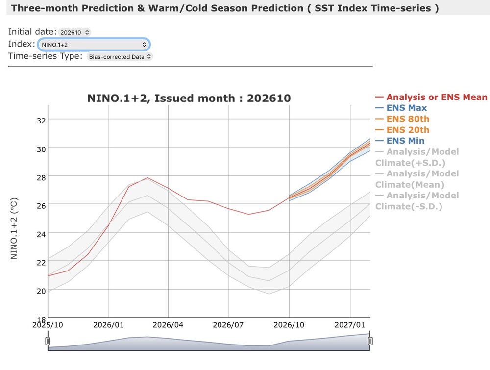
-

2026-2027 Record-breaking El Nino
LakePaste25 replied to Stormchaserchuck1's topic in Weather Forecasting and Discussion
-PDO is reflective of a multi year La Nina state, which we have been in up until this event started. The idea that we should expect the strongest El Niño in our lives to be impacted by extratropical <20C waters in the pacific due to the fact that we were in a multi year Niña is not something I agree with. PDO regions do not show up on any Rossby wave map as a source. The multiple posts in here suggesting that the pattern we have had in summer and autumn was not only influenced by the PDO but primarily caused by the PDO is absurd to me. -
-

Occasional Thoughts on Climate Change
WolfStock1 replied to donsutherland1's topic in Climate Change
Nothing that I posted there is misaligned with any of my previous posts, at least that I'm aware of. That's another disturbing trend I see. Anyone who tries to be pragmatic (e.g. playing devil's advocate with some assertions, as I am wont to do) is labeled "DENIER!!!". It's why a lot of people see religious / cultish aspects in the movement.- regular attempts to label those who don't agree whole cloth with the most extreme positions as heretics. -
Flu hitting early this year! My daughter had it last week (somehow escaped the rest of us) and I know 2 others who already had it. Feel better!
-
Wasn’t that the cold shot freeze and snow that vanished?
-
That would be about as fun as it gets up here for wind minus a 38 or 1950. LLJ ripped due west from coastal NH into VT
-
Nah that isn’t happening. First weenie day 10 disappointment of the season.
-
I'm ready for my pencil thin line of gusty showers! (hoping for more!)
- 2,564 replies
-
- 1
-

-
- severe
- thunderstorms
- (and 7 more)
-
The eerie calm before the big storm.
-

2026 Mid-Atlantic Severe Storm General Discussion
high risk replied to Kmlwx's topic in Mid Atlantic
Let's fire up the severe thread for one last hurrah! SLGT for parts of the region tomorrow; MRGL for just about everyone else. Strong front approaches Friday evening with a good signal for a line of forced convection just ahead of it. Shear will be very strong, and some forecast soundings have a little bit of instability. The threat of a few damaging gusts seems legit. (I'm ignoring the 2% TOR for now.)- 2,564 replies
-
- 2
-

-

-
- severe
- thunderstorms
- (and 7 more)
-
Might be a decent week next week.
-

2026-2027 Record-breaking El Nino
40/70 Benchmark replied to Stormchaserchuck1's topic in Weather Forecasting and Discussion
@LakePaste25I'd love to hear why the PDO isn't reflective of crucial forcing. The "X" emoji's are similar to the gaudy AI visuals in that they add very little value. -PDO is not reflective of El Nino, but rather a competing force...you can ignore it at your own peril, or figure out what said force is and account for it. -

Occasional Thoughts on Climate Change
LongBeachSurfFreak replied to donsutherland1's topic in Climate Change
Well finally some sense. Agreed, it’s not that big of a problem (yet). But not thinking about future generations is selfish. I’m sure there are a few environmental issues from the past you would have wanted not to have happened. Personally I wish we left at least a percentage of old growth forest on the east coast. Easily avoidable in retrospect. But past generations were, selfish. Same game here. Difference is we can do something about it. . -
Euro had a heckuva run with that potential coastal low last night
-

2026-2027 Record-breaking El Nino
A-L-E-K replied to Stormchaserchuck1's topic in Weather Forecasting and Discussion
ready 2 torch -
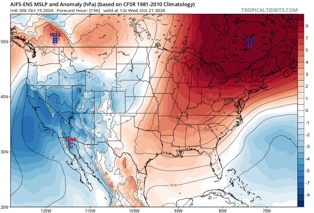
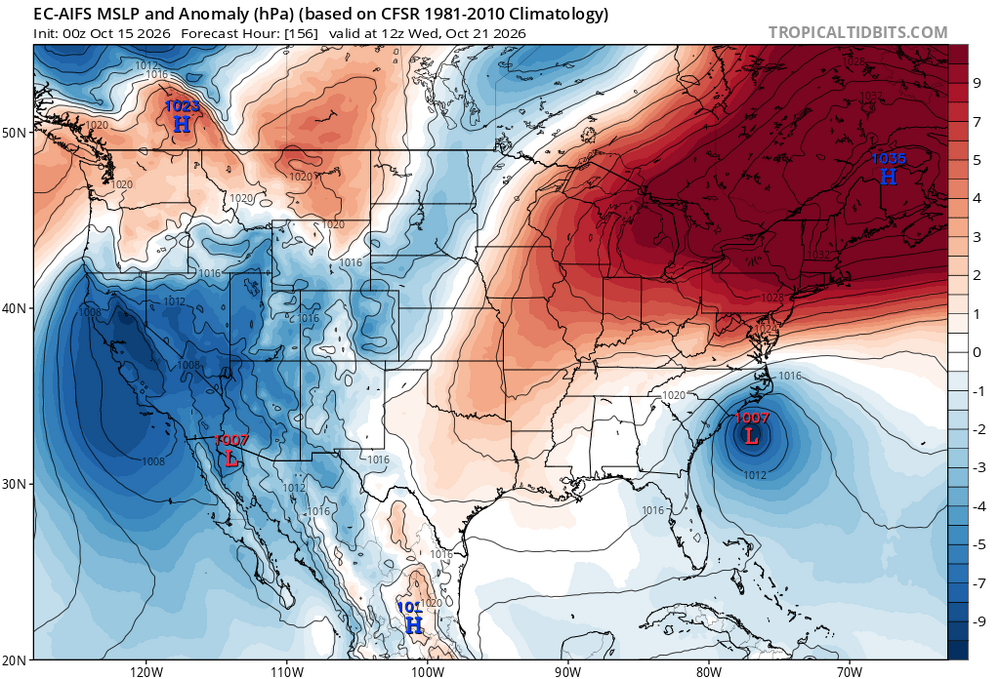
At least another period of extended onshore flow with the big high to the north and developing low somewhere underneath.
-
2026-2027 Record-breaking El Nino
40/70 Benchmark replied to Stormchaserchuck1's topic in Weather Forecasting and Discussion
Right, but it's a refection of hemispheric forcing that absolutely has a profound effect on the long wave pattern. You are missing the point....it's like seeing a juiced-up disturbance ridging the STJ and up the coast, but telling people not to worry about the arctic high parked over Ottawa because it can't produce precipitation. Sure, but it will interact with entities that absolutely can. Stop viewing the atmosphere in a vacuum and focus on how everything interacts. You don't consume a bag of flower for dessert, right? No, you bake into the pie first. -

Occasional Thoughts on Climate Change
Typhoon Tip replied to donsutherland1's topic in Climate Change
https://phys.org/news/2026-10-countries-vulnerable-fossil-fuel-phaseout.html seein' as y'all arguin' about it. Apropos timing from Potsdam Institute for Climate Impact Research (PIK) ... -
are you new here? the nonsense talk happens year 'round. Certain posters constantly wishcasting is nothing new. oh, and I am pretty sure that @Prismshine Productions is not a he.