All Activity
- Past hour
-
02-03 was my second most favorite winter after 1995-96. It had everything-- the Christmas Miracle, the February 20"+ KU snowstorm and the April snowstorm too.
-
Happy belated!
-

E PA/NJ/DE Spring 2025 Obs/Discussion
MGorse replied to PhiEaglesfan712's topic in Philadelphia Region
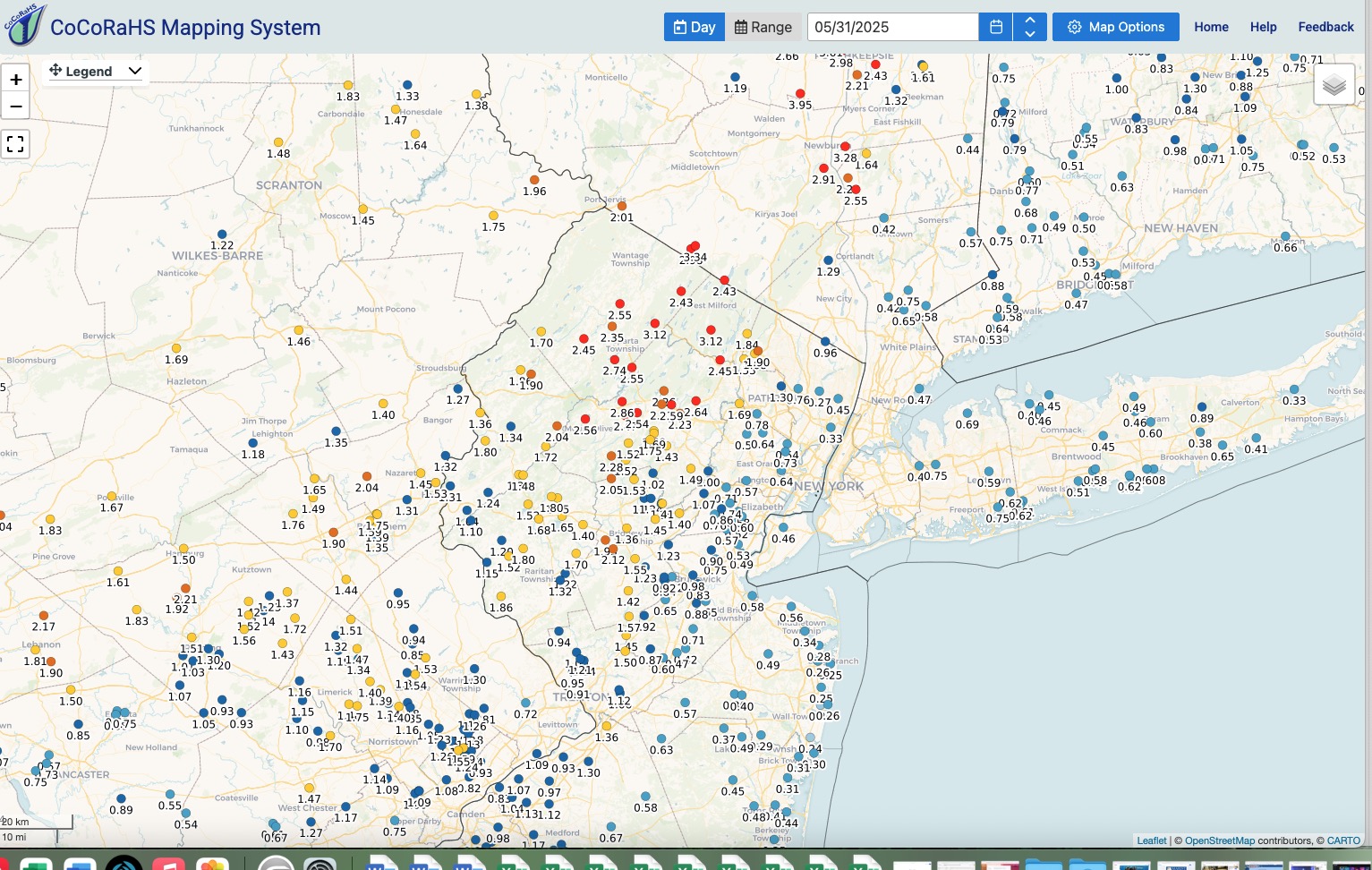
1.04 inches of rain. -
amazing to have it happen at the last possible moment and on Christmas lol. That was an out and out amazing winter, haven't had a beginning to end winter like that since (I rank it higher than 09-10, 10-11, 13-14 and 14-15 because of the 20 + inch big KU snowstorm in February a big snowstorm in April and the Christmas miracle snowstorm of course.)
-
More of the same old. The extensive high pressure across the North Pacific is indicative of a continued -PDO regime. It’s definitely taking longer to switch modes than I thought it would. My guess is that we have at least another year to go before there is a full scale decadal change….
-
and the "Storm will make it's own cold air" actually worked out too. It was in the low 50's here that morning with heavy rain-by midafternoon it was 30 with heavy snow
-
Yeah that’s a big part of it. From my memory that storm was bombing out as it passed overhead. Likely very strong dynamics were able overcome drying.
-
That 2.28 in Chester makes sense based on my wheelbarrow. Last of it lifting out now.
-
 DCA: +2.4 NYC: +2.4 BOS: +2.0 ORD: +1.4 ATL: +1.2 IAH: +1.0 DEN: +0.7 PHX: +2.5 SEA: +0.2
 -
I really liked the calls for under 1 inch for the city and points east. 0.75 was the highest near me, about what I expected.
-
Most guidance and WPC were all over the location of potentially max rainfall for the last 2 days and it worked out well.
-

Central PA Spring 2025
Itstrainingtime replied to canderson's topic in Upstate New York/Pennsylvania
Current totals: 0.17" since midnight 1.11" so far for the event 10.37" so far in May. -
The one time back end snows actually worked out.
-
we bottomed out at 29.16 now slowly rising as the winds increase.
-
Odd weather down here....feels like we went through the 'eye' of the storm, winds went calm, sun came out. Now we are getting into the 'SW quadrant' with heavy rains and pretty gusty too
-
 DCA: +2.1 NYC: +2.2 BOS: +2.1 ORD: +1.9 ATL: +0.3 IAH: +0.5 DEN: +1.8 PHX: +1.0 SEA: +1.9
 -
Impressive amounts locally. Looks like we’re in the backside of the low and will be there for a few hours. I doubt we will get any heavy rain later with this backside hanging around.
-
57.6° +RA Cats and dogs right now. Jfc
-
It was clear the last 48 hours this storm would favor N NJ and Hudson Valley. It's not some surprise at least not to me.
-
Tony how many did JFK have in 1991?
-
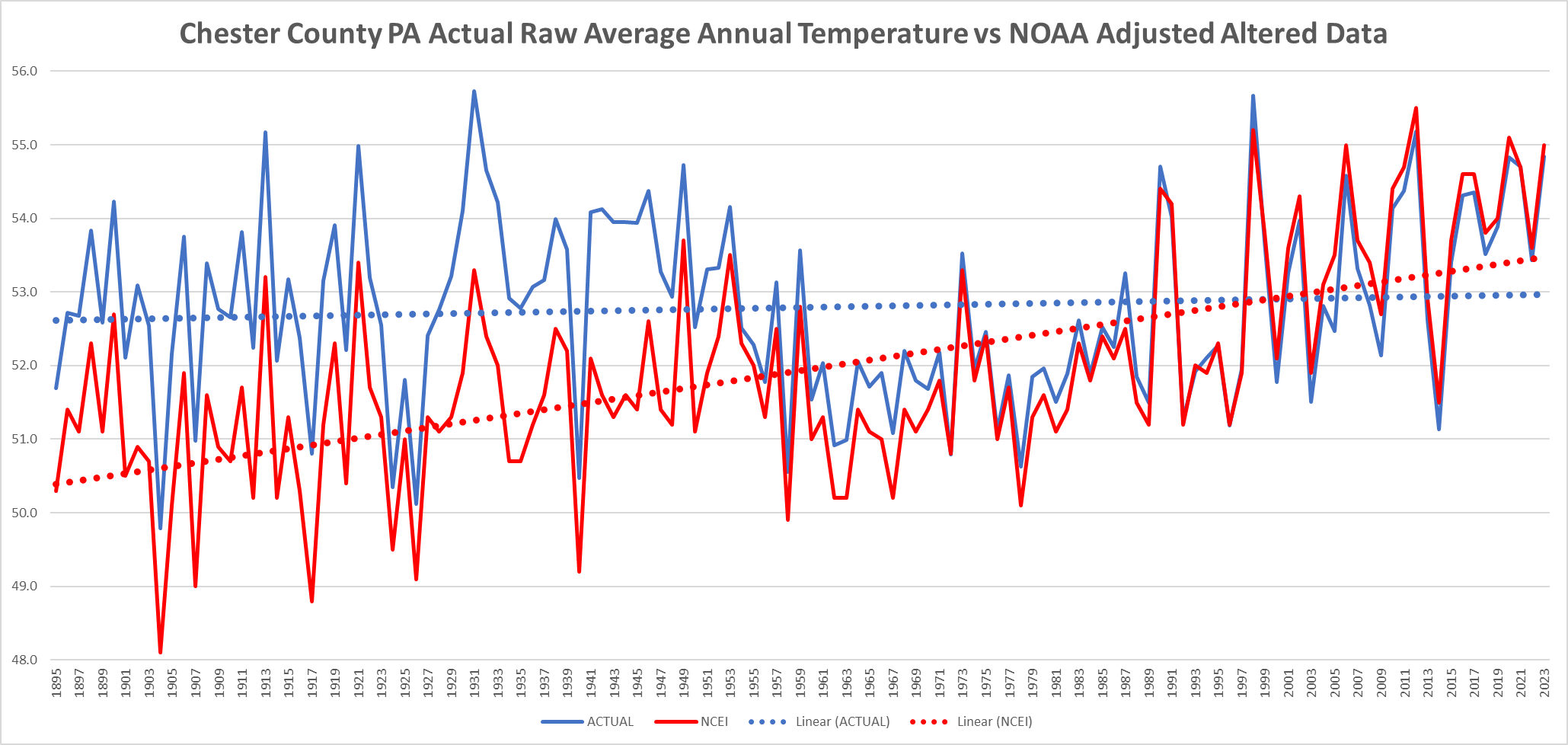
Charlie above attempts to alter even further the official NWS data. He chooses to not include many other valid NWS observation sites in his chart above...plus his explanation as always ignores the continued non stop chilling of the data for another 30 years from 1969 thru 1999. Let's once again show the factual actual raw non-altered real National Weather Service data for Chester County PA from 1893 thru 2024. Guess what we see? Clearly, without the spurious altered data shown in red - almost flat annual temperature trends across the NWS Chester County stations. Facts (blue raw) over fiction (red altered)as always wins!

-
I'd like to see what the storm track was with that and how it compares to this one. About 95% of the time these back end snows never work out -- and it's usually for geographical reasons -- NW winds on the backend downslope and dry everything out (wonderful for the spring and summer).
-
Correct! And thank you.
-
1991 - May 90 degree days EWR: 8 NYC: 5 LGA: 4 JFK: 3 2022: PHL: 47 (Apr: 0 ; May: 3 ; Jun: 5; Jul: 19 ; Aug: 18 ; Sep: 2) EWR: 49 (Apr: 0 ; May: 4 ; Jun 6 ; Jul: 20; Aug: 18; Sep: 1) TTN: 31 (Apr: 0 ; May: 2 ; Jun: 1 ; Jul: 14 ; Aug: 14; Sep: 0) LGA: 30 (Apr: 0 ; May: 3 ; Jun: 3; Jul : 11; Aug: 13; Sep:0 ) ACY: 33 (Apr: 0 ; May: 2 ; Jun: 3 ; Jul: 16; Aug: 12; Sep: 0 ) TEB: 35 (Apr: 0 ; May: 3 ; Jun : 3 ; Jul: 13 ; Aug: 16; Sep: 0 ) NYC: 25 (Apr: 0 ; May: 2 ; Jun:1 ; Jul: 10 ; Aug: 11; Sep: 1 ) JFK: 16 (Apr: 0 ; May: 1 ; Jun: 1; Jul: 9 ; Aug: 5 ; Sep: 0 ) ISP: 13 (Apr: 0 ; May: 2 ; Jun: 1 ; Jul: 5 ; Aug: 5; Sep:0 ) New Brunswick: 42 (Apr: 0 ; May: 3 ; Jun: 3; Jul: 17; Aug: 18; Sep: 1 ) BLM: 28 (Apr: 0; May: 4 ; Jun: 2 ; Jul: 12 ; Aug: 10) 2018: PHL: 30 (April: 0; May : 1 ; June: 4 ; Jul: 11; Aug: 10 ; Sep: 4 ) EWR: 36 (April: 0; May: 4 ; June: 5; Jul: 9 ; Aug: 14; Sep: 4 ) TTN: 29(April: ; May: 2 ; June: 4; Jul: 8 ; Aug: 11; Sep: 4) LGA: 38 (April: 0; May: 4; June: 4; Jul: 10; Aug: 16; Sep: 4) ACY: 38 (April: 0; May: 3; June: 5 ; Jul: 11 ; Aug: 13 ; Sep: 4) TEB: 41 (April: 0; May: 4 ; June: 5 ; Jul: 10 ; Aug: 18; Sep: 4 ) NYC: 21 (April: 0; May: 2 ; June: 3; Jul: 6; Aug: 7 ; Sep: 3) JFK: 8 (April: 0; May: ; June: 1; Jul: 2 ; Aug: 4; Sep: 1) ISP: 8 (April: 0; May: ; June: ; Jul:2 ; Aug: 5 ; Sep: 1) New Bnswk: 33 (April: , May: 2, June: 4, July: 10; Aug: 13 ;Sep:; 4 )
-
Absolutely wrap around. The front end of the storm was all rain.