All Activity
- Past hour
-
How much snow pack you have left? Mine finally gave about 2 weeks ago
-
71F off low of 38F. Diurnal ranges been slowly closing up but I think my favorite weather is 30s to 70s… though 40s to 80s probably does top it.
-
I got ~0.15” this morning.
-

Occasional Thoughts on Climate Change
TheClimateChanger replied to donsutherland1's topic in Climate Change
That sounds logical, but it’s not how the real Earth behaves. A true global average does have a seasonal cycle, and it’s not a sampling problem—it’s physics. The key issue is that the hemispheres aren’t equal. The Northern Hemisphere has a lot more land, and land heats and cools much faster than oceans. The Southern Hemisphere is mostly ocean, which responds slowly and dampens temperature swings. So when the Northern Hemisphere warms in summer, it pushes the global average up more strongly than the Southern Hemisphere can offset during its winter. The result is a real, global annual oscillation. If both hemispheres were identical (same land/ocean mix, same heat capacity), then yes—your cancellation idea would work. But they’re not, so it doesn’t. Also, every independent global dataset—NASA GISS, NOAA, HadCRUT—shows the same seasonal wiggle. That wouldn’t happen if it were just “Iowa with a fancy name.” So the graph is doing two things at once: The up-and-down is the seasonal cycle (dominated by Northern Hemisphere land) The overall rise is the long-term warming trend Seeing both together is exactly what you’d expect from a properly constructed global temperature record. - Yesterday
-
Around 0.35” so far. Should be able to hit 0.5” with the second batch?
-
 May (May be) DCA NYC BOS ORD ATL IAH DEN PHX SEA +0.5 +0.5 +0.5 -2.5 -0.5 -0.5 +1.8 +2.4 +3.0
 -
Too much NW flow. Going to be cold and dry.
-
That elevated storm had a very high reflectivity seen by KFWS, and 2.5" hail in town. Now, just two warnings in Texas.
-
It's been nice slightly inland. Feels bad for the immediate coast but that is per usual
-

Central PA Spring 2026 Discussion/Obs Thread
Blizzard of 93 replied to Voyager's topic in Upstate New York/Pennsylvania
.23 of rain so far in Marysville as of 7:30. Steady rain continues. Heavy band looks to be developing out near Huntington & Franklin county. -
This is underwhelming on the Eastern Shore. 0.00" with showers falling apart.
-
77 at 6:23pm, warmer than expected. Wunderground still showing 99% chance of rain tonight.
-

2026-2027 El Nino
Stormchaserchuck1 replied to Stormchaserchuck1's topic in Weather Forecasting and Discussion
As the Kelvin Wave has continued to progress east, TAO/Triton has +4-5c anomalies now under Nino 1+2. Should be interesting to see if it surfaces in the east, along the American coast in the next few weeks. Still to be determined whether it's an east-based, west-based, or basin-wide event. I'm going toward basin-wide. -
35 with light snow for about the past hour. A chilly next few days up this way which I completely expected after a fairly mild April.
-
I totally get it man. Not trying to rub salt in a wound. This particular spring you all have really gotten shafted. From that week of 85-90 inland while you all doored . And these last 3 days of 67-72. And there’s been a few others.. and next week has a few days of 70-76 though you may do ok if flow is W. I remember posting in winter that the cold SST’s were going to ruin spring along the coast. Whenever that happens , the coast really suffers deep into spring
-
I'll give you April, which typically does suck here. March sucks everywhere when its not snowing. And by May dews and baseline temps start to creep up here regardless.
-
Absolutely. But look at where all the complaints have come from this spring
-
Yep, no rain within 100 miles today. After 80% chance with 1/2-3/4” forecast yesterday. But glad y’all got some much needed relief
-

Occasional Thoughts on Climate Change
WolfStock1 replied to donsutherland1's topic in Climate Change
Yes I know. I was talking about the annual seasonal fluctuations. E.g. if you set up a series of sensors in Iowa and monitored them for 86 years you could show the same type of data, with the same chart showing the seasonal variability as well as a general yearly upward trend. My point is that you wouldn't call that "global air surface temperature", because you're not measuring the whole globe with evenly-spread sensors - you're just measuring Iowa; and that explains why it goes up and down with the seasons - because all of your sensors are in the northern hemisphere. If instead the data was actually the whole global temperature - you shouldn't see the seasonal up-and-down like that, because the temperature rise in the southern hemisphere in the winter should match the temperature rise in the northern hemisphere in the summer - because that's the way the seasons work on earth. -
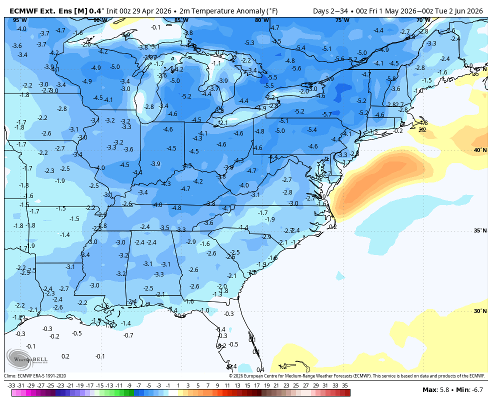
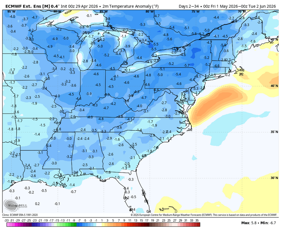
WB latest EPS weeklies for May. Cool, no big heat waves...average rainfall.
-
GFS is as dry as run for parts of NC as we’ve had this spring. And yes, Saturdays system is now east of I 95
-
And I doubt its more than a dozen days in April/early May where its 70 in CT and 44 here. I'd say it sucks here for a month..but inland areas share a good amount of the meh weather..just not all of it.
-
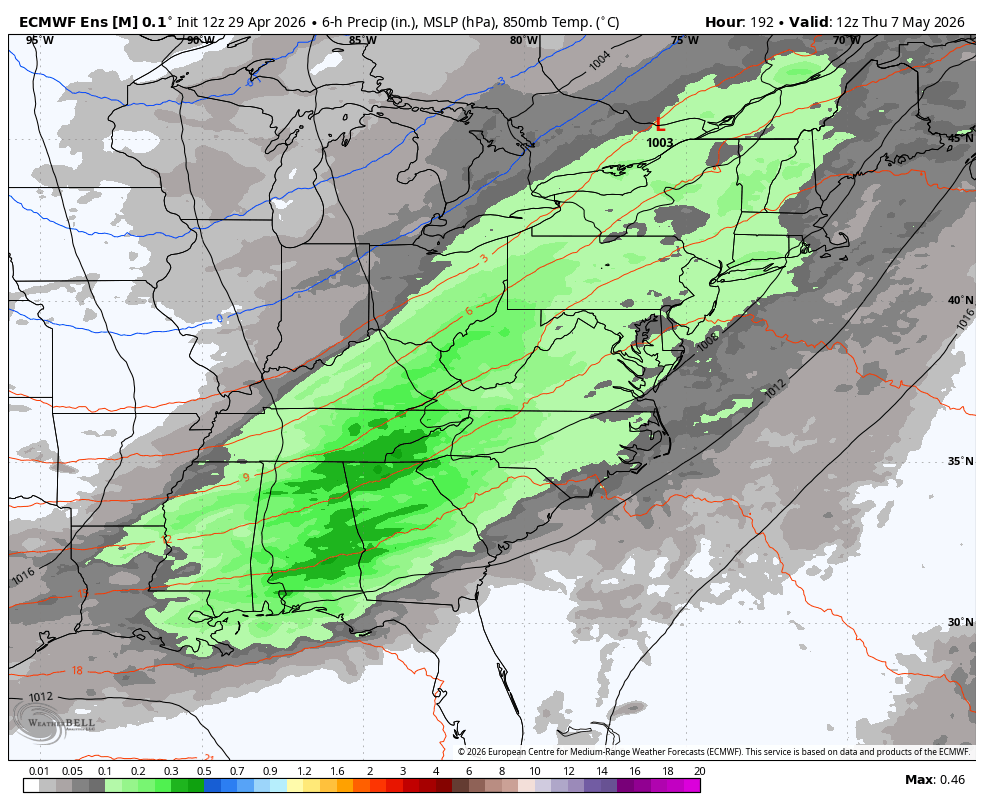
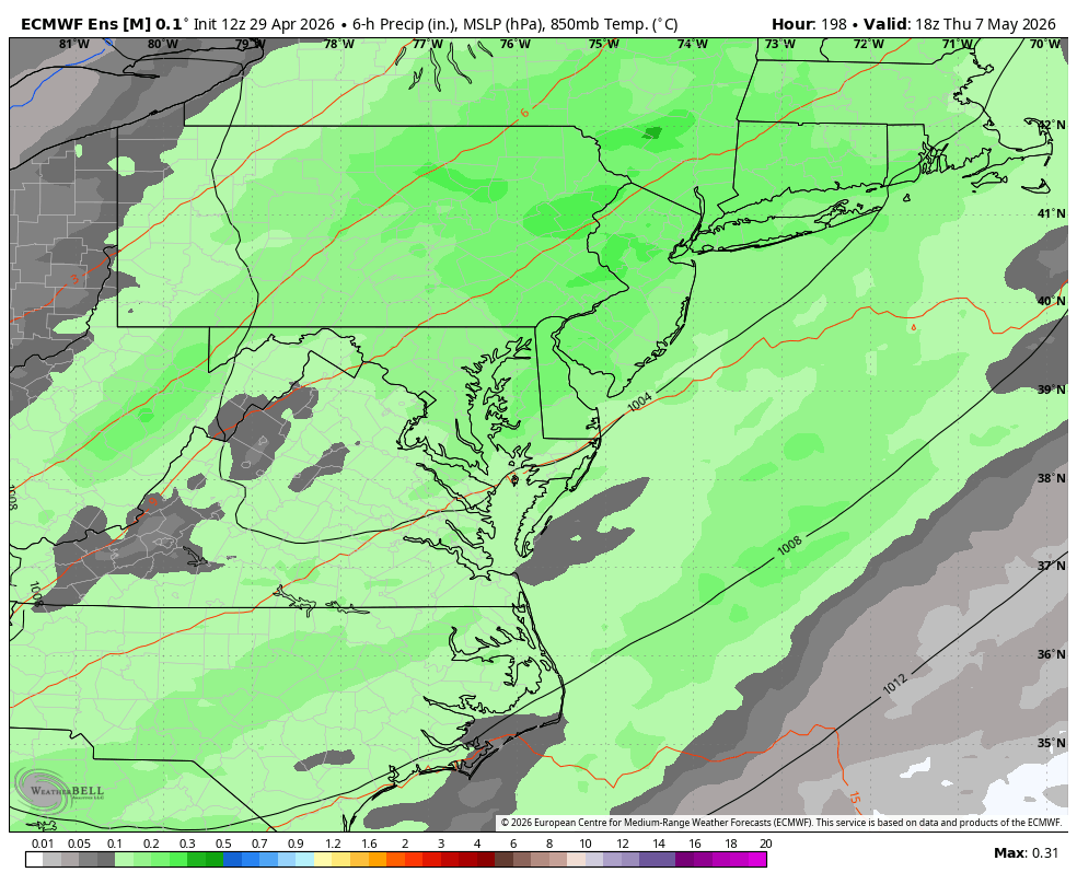
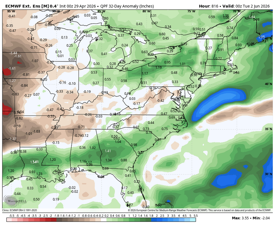
WB 12Z EPS. Next "significant" rain chance next Th.


-

E PA/NJ/DE Spring 2026 Obs/Discussion
JTA66 replied to PhiEaglesfan712's topic in Philadelphia Region
Got some raindrops falling in the vineyard this evening, 53 F. -
 May (May be) DCA NYC BOS ORD ATL IAH DEN PHX SEA +0.8 +0.4 +0.3 +0.5 +2.5 +0.9 +1.3 +1.6 +1.6


.thumb.gif.f92b16c631a1d15d405ed77b33f0710d.gif)