All Activity
- Past hour
-

2025-2026 ENSO
TheClimateChanger replied to 40/70 Benchmark's topic in Weather Forecasting and Discussion
Wow, that's quite impressive IMO, considering 1991-2020 was, by far, the warmest climatological normal period in recorded history. And the last 20 years are outpacing them by 0.6-1F across the board. One would think the warmer norms would tilt the scale towards more cooler than normal years, but, in fact, one finds the opposite phenomenon. Very intriguing. -

Friday February 6 FROPA / WINDEX small event
CoastalWx replied to HoarfrostHubb's topic in New England
Too much -

Friday February 6 FROPA / WINDEX small event
ORH_wxman replied to HoarfrostHubb's topic in New England
3k NAM gives BVY and Manchester-by-the-sea like 12-15”. -

Friday February 6 FROPA / WINDEX small event
Damage In Tolland replied to HoarfrostHubb's topic in New England
What if I had said 3-6? -
 Except with warm rain?
 -

Pittsburgh/Western PA WINTER ‘25/‘26
TimB replied to Burghblizz's topic in Upstate New York/Pennsylvania
Dry slotted to hell. Wonder if we even get an inch. -
RH spiked a Clear Spring Mesonet site. Maybe some flurries trying to reach the ground?
-
Friday February 6 FROPA / WINDEX small event
ORH_wxman replied to HoarfrostHubb's topic in New England
Yeah there’s general lift with the height falls and LL convergence does migrate across the region but where it slows down or temporarily stalls is where the jackpot will be. But I think almost everyone gets 1-2” minimum. -
Traffic cams show light snow falling just west of HGR.
-
25 / 10 off a low of 9,3. We'll see if today can make 5 above freezing in a row / and yet still be -5 or so below avg for the period. Light snow tonight and throughout the morning Saturday. Cold perhaps coldest 60 hour period Sat AM - Monday PM. Moderation next week but stubborn cold could yield a mix Wed and later Valentines weekend and into presidenets day 2/16. Beyond there a bit warmer overall but still close to avg.
-

Friday February 6 FROPA / WINDEX small event
Typhoon Tip replied to HoarfrostHubb's topic in New England
Agreed. I don't believe the front really gets E of that trough axis... I think it kind of slows as it incurs on that thing's axis; then it collapses thru after the fact. -
LMAO! Nowhere did I say I know more than people with MET degrees. I said that SOME (not all) people here, with or without Met degrees think they are such hot **** and look down on the so called "weenies". Im simply bringing those people back down to earth. Once again, there is no reason for the arrogance. How is it that you can't understand this very basic concept?
-
Holy hell yesterday’s low turned into a monster in the Atlantic off the Carolina coast. What could have been!!!
-
Wind sucks. My only solace at this point is not living under massive trees and having underground power lines. Any outages/damage will suck tomorrow with the frigid temps at the same time.
-
Morning low of 7 this morning. Scraped probably a 1/2" layer of frost off the windshield.
-
Score the trifecta!
-

February 2026 Medium/ Long Range Discussion: 150K Salary Needed to Post
Ji replied to Weather Will's topic in Mid Atlantic
so much changed. the lead wave was suppose to cut under the block. but this look now is completely different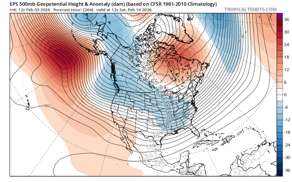
-
My NWS point-and-click has a 60mph gust for noon tomorrow. I'm not sure I've seen something like that since the big March windstorm in the late 2010s.
-
Friday February 6 FROPA / WINDEX small event
CoastalWx replied to HoarfrostHubb's topic in New England
Most will get 1-3 outside of it. Even Kevin’s 2-4 seems reasonable. -
The Nam only has 12. Either way it’s going to be cold af
-
Consider them the outlier right now. Probably a bit too cold. Mid-teens in the afternoon is a better bet.
-

Friday February 6 FROPA / WINDEX small event
Kitz Craver replied to HoarfrostHubb's topic in New England
Central CT subsidence west of the IVT -
I agree it will end up being a cold and possibly snowy month overall, but I do agree with the idea of a mid month relaxation period.
-
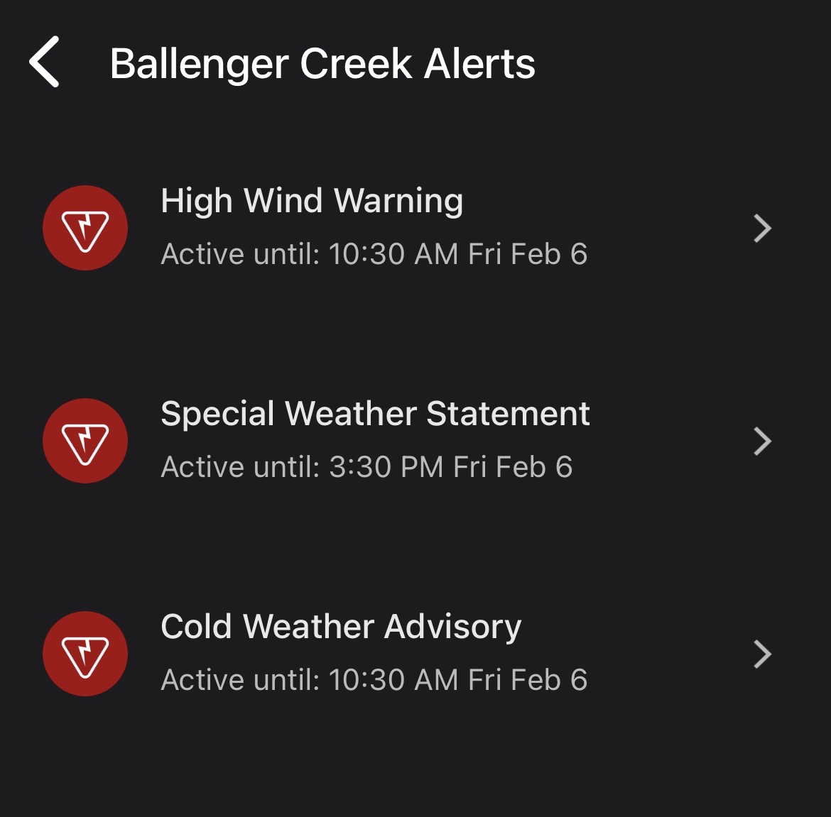
GSP really should extended advisory down further so this doesn't catch people off guard. The ground is prime for this to be a mess on the roads and temps keep trending downwards.
-

Friday February 6 FROPA / WINDEX small event
TauntonBlizzard2013 replied to HoarfrostHubb's topic in New England
Agreed. I think many who don’t end up in the Norlun are going to be disappointed. And good look pinning down exactly where it will set up.


.thumb.jpeg.f5c6ba9d911ec96b3b124f8606aee58e.jpeg)