All Activity
- Past hour
-
Username checks out.
-
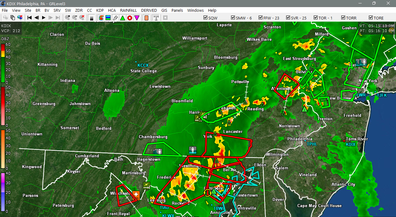
The terminal radars are going to be very useful as always during this. We are VERY spoiled by having this sort of radar coverage in our region. TDCA has an intense wind signature showing up in MoCo just N of Gaithersburg. It might be trying to form a little "notch" too.
- 1,593 replies
-
- 1
-

-
- severe
- thunderstorms
- (and 7 more)
-
And it’s tornado warned
-
BULLETIN - EAS ACTIVATION REQUESTED Tornado Warning National Weather Service Baltimore MD/Washington DC 528 PM EDT Tue Jul 28 2026 The National Weather Service in Sterling Virginia has issued a * Tornado Warning for... Northeastern Harford County in northern Maryland... Northwestern Cecil County in northeastern Maryland... * Until 600 PM EDT. * At 528 PM EDT, severe thunderstorms capable of producing a tornado were located along a line extending from near Delta to Bel Air North, moving east at 40 mph. HAZARD...Tornado. SOURCE...Radar indicated rotation. IMPACT...For those in the direct path of a tornado touchdown, flying debris will be dangerous to those caught without shelter. Damage to roofs, siding, and windows may occur. Mobile homes may be damaged or destroyed. Tree damage is likely. * These dangerous storms will be near... Aberdeen, Bel Air South, Bel Air North, Octoraro, Rock Springs, and Conowingo around 535 PM EDT. Havre De Grace, Aberdeen Proving Ground, Perryman, and Richardsmere around 540 PM EDT. Rising Sun, West Nottingham, Farmington, and Woodlawn around 545 PM EDT. Other locations impacted by these tornadic storms include Perryville, Cardiff, Churchville, Darlington, Carsins, Pylesville, Scarboro, Forest Hill, Bynum, and Port Deposit.
-

2026-2027 Super El Nino
Stormchaserchuck1 replied to Stormchaserchuck1's topic in Weather Forecasting and Discussion
Just really pretty muted. If anything the orientation of precip is more La Nina like for +QBO -
Lots of mud and rocks and the golf course across the road was washed out
-

2026 Mid-Atlantic Severe Storm General Discussion
somecallmetim replied to Kmlwx's topic in Mid Atlantic
Where that baltimore cell meets the main line could get interesting. -
Baltimore and Harford county part of the line is bowing out
-

2026-2027 Super El Nino
Wannabehippie replied to Stormchaserchuck1's topic in Weather Forecasting and Discussion
I know it is a long ways off yet, but do we have enough historical data to tell us that after a super El Nino whether or not we go to the other extreme with a super/very strong La Nina? -
Got some storms starting to fire as far west as my area now. This one was rolling in from the wnw: This one is over Oak Ridge and Hardin Valley: Nothing severe down here, but these suckers went up quick. I was doing yard work and checking out the clouds and nothing could seem to break the cap, although there must have been some lower level mixing with occasional decent wind gusts.
-
 Not really near me. That’s same area that got creamed this afternoon in the valley
 -
Hopefully enough of this rain will fall over the watershed areas to get us further on the upswing of eliminating drought conditions.
-
So at home .79” out of that line. Monthly total so far of 9.76” This year has been so different from the last two years. The younger Ms. J has gotten off easy with not having to keep up on watering my deck plants.
-
 National Weather Service Boston/Norton MA 345 PM EDT Tue Jul 28 2026 .WHAT HAS CHANGED... Expanded the flood watch to include Worcester, Windham, and Providence counties. Increased rainfall totals with a widespread two to four inches expected for most areas, and up to five to seven inches possible for the Berkshires and Worcester Hills
 -

E PA/NJ/DE Summer 2026 Obs/Discussion
Birds~69 replied to PhiEaglesfan712's topic in Philadelphia Region
Looks like a line is trying to form somewhat...a couple heavy downpours here. 76F/DP 65F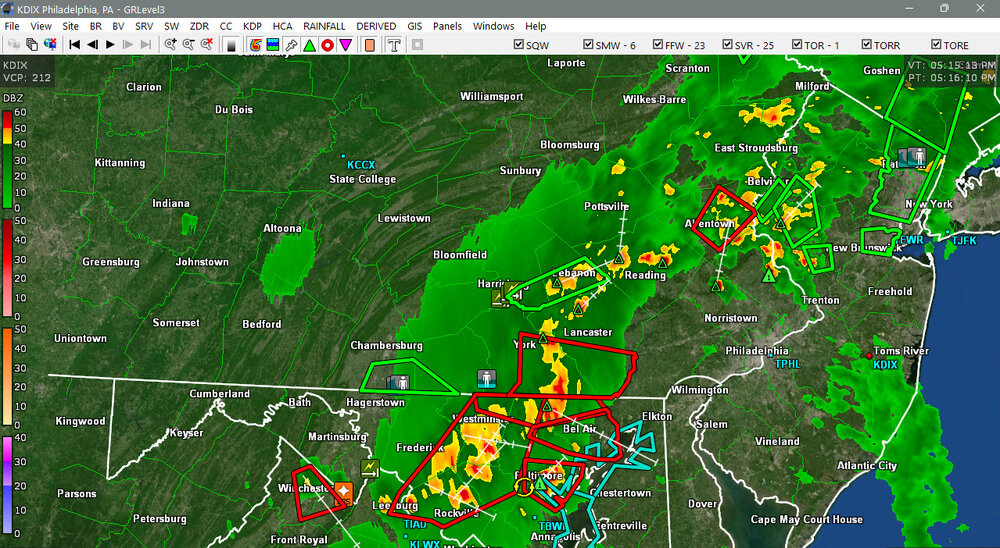
-
I went out for a brief walk around 2:50pm today. I heard a loud rumble of thunder, jogged/ran home. By the time I got upstairs to my condo it was pouring outside.
-

2026 Mid-Atlantic Severe Storm General Discussion
SnowenOutThere replied to Kmlwx's topic in Mid Atlantic
The Fairfax county split is pretty pronounced today. Hoping the storms near Winchester can rotate in? -
Stuff starting to pop in CT near Kevin heading north.. see how that goes the next couple hours
-
A storm will bring rain and thunderstorms to the region through tomorrow. A storm total 2.00"-4.00" rainfall is likely, along with locally higher amounts. A general 0.50"-1.50" is likely across most of Long Island. Following the storm, Thursday and Friday will see a continuation of below normal readings. Temperatures could return to near seasonable levels for the weekend. The ENSO Region 1+2 anomaly was +3.8°C and the Region 3.4 anomaly was +2.2°C for the week centered around July 23. For the past six weeks, the ENSO Region 1+2 anomaly has averaged +3.38°C and the ENSO Region 3.4 anomaly has averaged +1.92°C. The ongoing strong El Niño will continue to strengthen through the summer. The SOI was -24.19 today. The preliminary Arctic Oscillation (AO) was +0.191 today. Based on sensitivity analysis applied to the latest guidance, there is an implied near 99% probability that New York City will have a cooler than normal July (1991-2020 normal). July will likely finish with a mean temperature near 76.3° (1.2° below normal). Supplemental Information: The projected mean would be 0.2° below the 1981-2010 normal monthly value.
-
Thunder in the distance. Hoping I can grill my brats before the storm starts lol
- 1,593 replies
-
- 1
-
-
- severe
- thunderstorms
- (and 7 more)
-
Intermittent but very loud pingers here in Fed hill. Picking up what looks like penny to nickel sized hail. Cool! Update: I ate one for the novelty value before realizing I picked it up off a baltimore sidewalk
-
Yeah, that round was frustrating. That cell over Lusby 10 miles to my south would have been nice since there's no guarantee on the later stuff. The big gap in the main line is aimed right at us; I hope it fills in!
-
 Wow. He’s not even offering a parting gift.
-
Much needed rain, lot of lightning.
- 1,593 replies
-
- 5
-
-
- severe
- thunderstorms
- (and 7 more)
-
Hopefully no one was trapped by the mudslide.