All Activity
- Past hour
-
November 2025 general discussions and probable topic derailings ...
NoCORH4L replied to Typhoon Tip's topic in New England
We had the big torch drought tho -
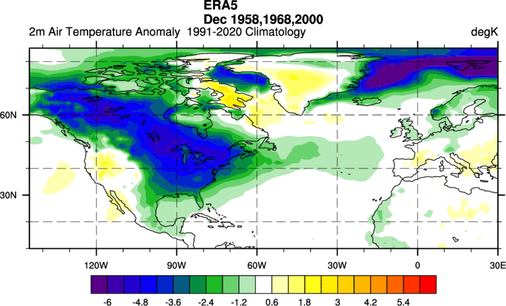
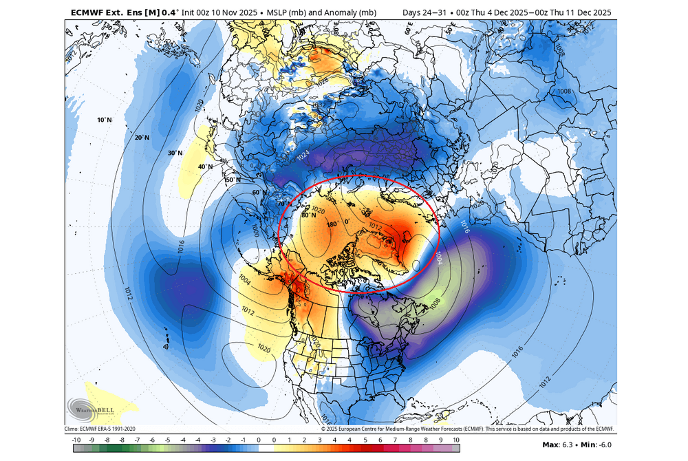
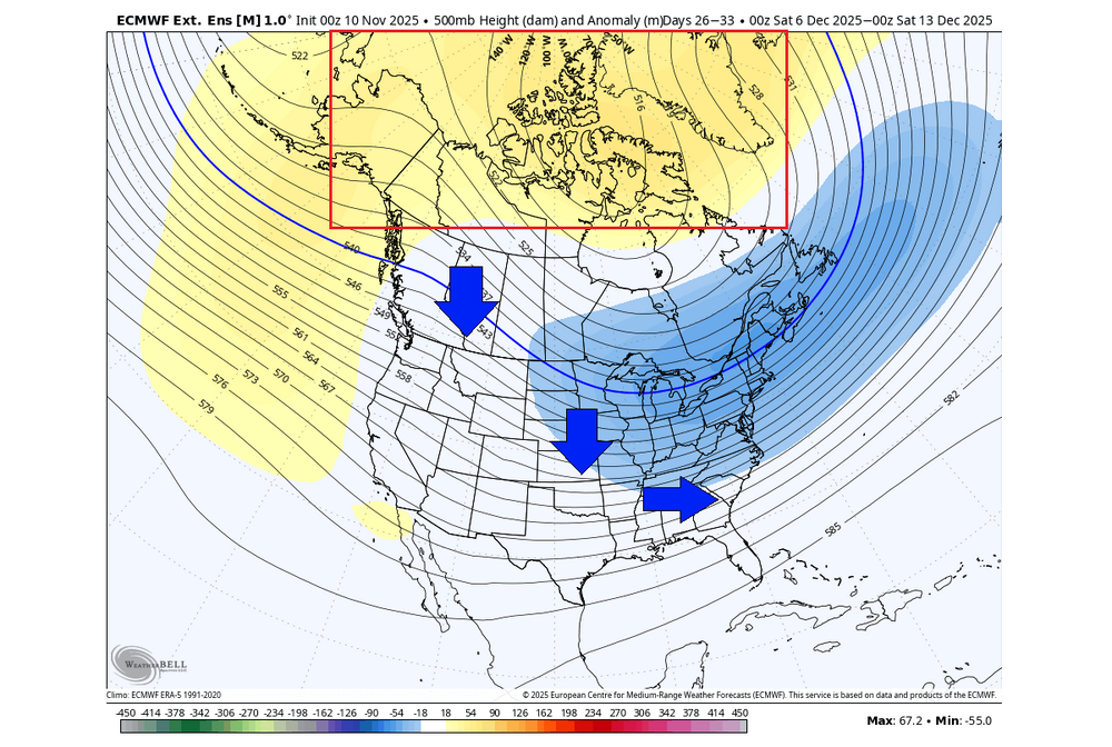
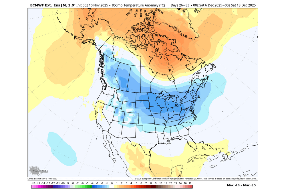
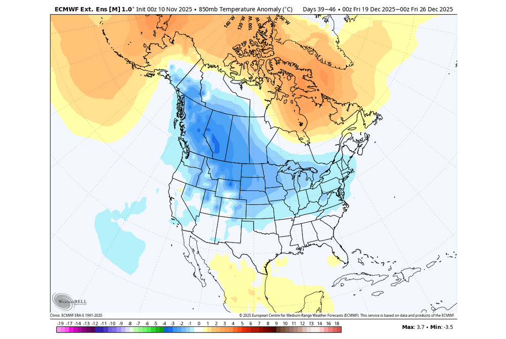
The last one looks MJO 6 Canonical Nina basically.
-
-
We didn’t get as cold as forecast here but did have a hard freeze. Bottomed out at 30.0 and were at/below freezing for 5 hours
-

November 2025 general discussions and probable topic derailings ...
Ginx snewx replied to Typhoon Tip's topic in New England
Meltdowns Nov 11 over not getting snow in SNE really takes the cake. Those posters are not living in reality. Ave snow is 2 inches and the great majority of that is after Tday. I suppose it makes them feel better but cmon get real. -

November 2025 general discussions and probable topic derailings ...
WinterWolf replied to Typhoon Tip's topic in New England
Was just outside…felt dam cold/winter like cold. Not too shabby for 11/11 imo. We take. -
Dropped to 31.9 here…I guess that counts! I had my doubts last night about dropping much lower, these setups usually underperform temp wise.
-

November 2025 general discussions and probable topic derailings ...
Ginx snewx replied to Typhoon Tip's topic in New England
Steve Ayers got smoked in his Smoky Mountains home. -
Ha! It was a poor attempt at humor. When we're in the middle of a 55-60 degree stretch in Jan with hopeless D10+ progs, SSW talk enters the chat like clockwork. And it never amounts to much lolol. Imho, some winters just want to work and others don't no matter what. Wasted blocking and random storms in the middle of futile indices are as common as typical/predictable stuff that produces. The early signs of the upcoming winter are promising. I think we can all agree on that. I've suspected we're on the front side of a longer duration blocking cycle for a couple of years now. Get things right in the AO/NAO region for the balance of winter and a ratter is prob off the table. Big winters outside of mod ninos are notoriously hard to predict. 13-14 was pessimistic leading in and we all fondly remember that one. I certainly didn't see it coming in Nov. The early Dec storm was a signal but then it got crazy warm before legit winter set in for 3 straight months. Any event during the first half of Dec is usually a reliable sign of an "acceptable" winter. So far it looks pretty good in general for that this year. Time will tell as always
-
Canaan Resort reporting 14”.
-

November 2025 general discussions and probable topic derailings ...
Ginx snewx replied to Typhoon Tip's topic in New England
Totally wrong -

November 2025 general discussions and probable topic derailings ...
Ginx snewx replied to Typhoon Tip's topic in New England
-
2025-2026 ENSO
PhiEaglesfan712 replied to 40/70 Benchmark's topic in Weather Forecasting and Discussion
Yeah, people forget about that cool down in the last third of March 2011. Turned a solidly positive temperature departure to a near normal. I feel like the previous winter (2009-10) was more abrupt. Baltimore had 80 inches of snow by February 10, and the snow just stopped. The change was so dramatic, to the point there was record 90-degree heat during the first week of April. It's amazing, though, how so much snow was able to fall in such a short time during those 2 winters. And in 2 very different ENSO states (2009-10 being a strong el nino, and 2010-11 being a strong la nina). -
I had a Snapchat from one of my friends going deer hunting in Hamilton NC and it looked like an inch. Side roads were covered too. They must’ve gotten under some rates
-

11-9/11-10 Early Season Snow Obs.
Holston_River_Rambler replied to John1122's topic in Tennessee Valley
Before the high clouds move in, here is a a tru color GOES pic of the area: High Knob snow shadow in effect: -
November 2025 general discussions and probable topic derailings ...
SJonesWX replied to Typhoon Tip's topic in New England
Nah, warmth confirmed by the pope -
Over my way it began when it stopped for you all. Snowiest February on record and the Oklahoma state record coldest temperature.
-
-

11-9/11-10 Early Season Snow Obs.
Holston_River_Rambler replied to John1122's topic in Tennessee Valley
Some pics form yesterday: Convective cloud tops: Snow on blossoms: Snow on kudzu: Probably about half an inch total IMBY: -
Here in NJ, after Jan, I got 5.25" total. Dec and Jan I got 55", so 60.25" total. We were on our way to breaking the 95/96 winter then it pretty much did stop.
-

Central PA Fall Discussions and Obs
Mount Joy Snowman replied to ChescoWx's topic in Upstate New York/Pennsylvania
Low of 30. It is cold out there with the wind. Love hearing all these first flake tales. #WinterIsComing





.thumb.png.4150b06c63a21f61052e47a612bf1818.png)
