All Activity
- Past hour
-
 canada pharmacy 24h or reputable canadian online pharmacies 77 canadian pharmacy http://prosports-shop.com/shop/display_cart?return_url=http://mapplemed.com pharmstore canada and http://clubdetenisalbatera.es/user/jkkbsconbj/ thecanadianpharmacy [url=http://maps.google.com.na/url?q=https://mapplemed.com]canadian pharmacy 24h com[/url] canadian drug and [url=https://armandohart.com/user/kzvotuurmd/?um_action=edit]canadian pharmacy mall[/url] canadian pharmacy mall
 -
My PWS recorded .35", but given that it fell in :10, and was falling sideways most of that time, maybe more?
-
Time for the daily monsoon rains in the Western Maryland mountains. Feels more like Florida. We don't seem to get normal rain anymore. Its blow out the gullies and wash away all that mulch and top soil from your new landscaping type rains. Even put in rip rap and culverts but those get overwhelmed.
-

2026-2027 Record-breaking El Nino
LakePaste25 replied to Stormchaserchuck1's topic in Weather Forecasting and Discussion
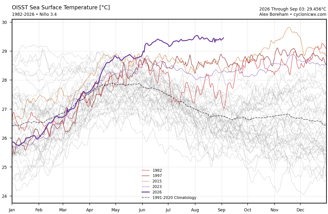
I’m sorry but this is just incorrect to say it’s not the warmest. You should specify that it’s not the highest relative Nino 3.4 index. To flat out say “it’s not the warmest” is incorrect. If my local airport reaches 101, that would be the warmest temperature on record, since the all-time record is 100. If i come up with some “relative temperature” it doesn’t change that fact. The fact still stands that Nino 3.4 is at its all time highest, and has been consistently.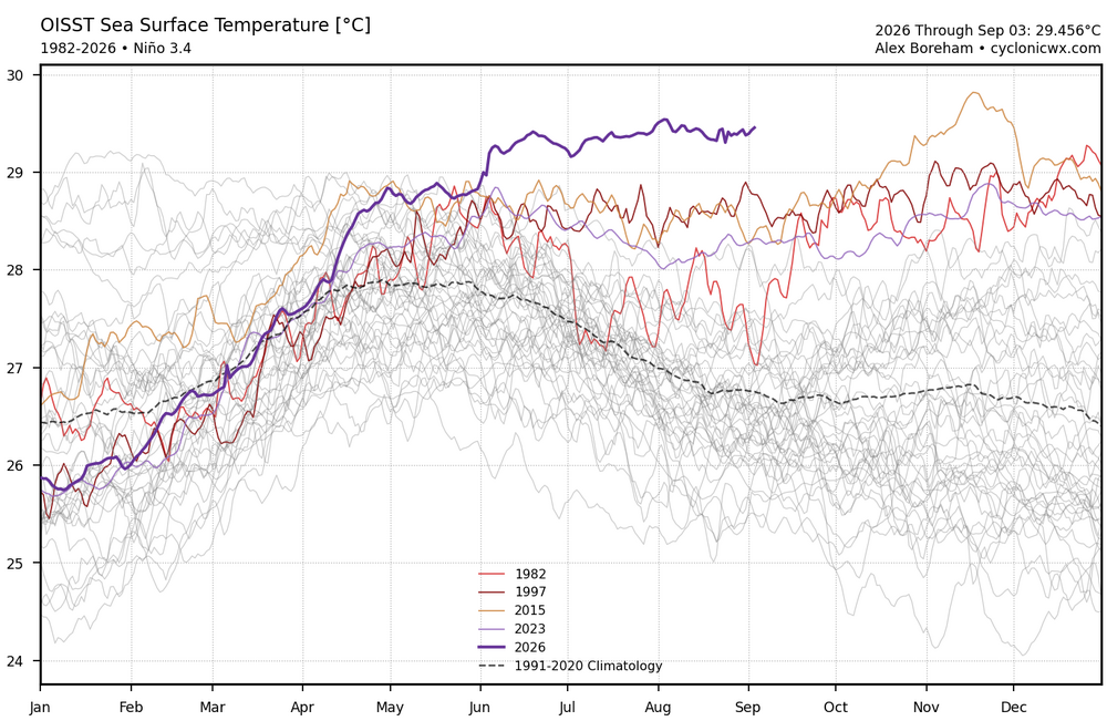
-

2026 C and E Pacific tropical activity
WxWatcher007 replied to GaWx's topic in Tropical Headquarters
-
Septorcher 2026 Discussion - Endless Summer
WxWatcher007 replied to Damage In Tolland's topic in New England
What a year in Hawaii -

E PA/NJ/DE Autumn 2026 Obs/Discussion
BBasile replied to PhiEaglesfan712's topic in Philadelphia Region
Picked up 0.22' of rain this morning. So, 2.04" on the month and 18.69" since July 1. -

2026-2027 Record-breaking El Nino
bluewave replied to Stormchaserchuck1's topic in Weather Forecasting and Discussion
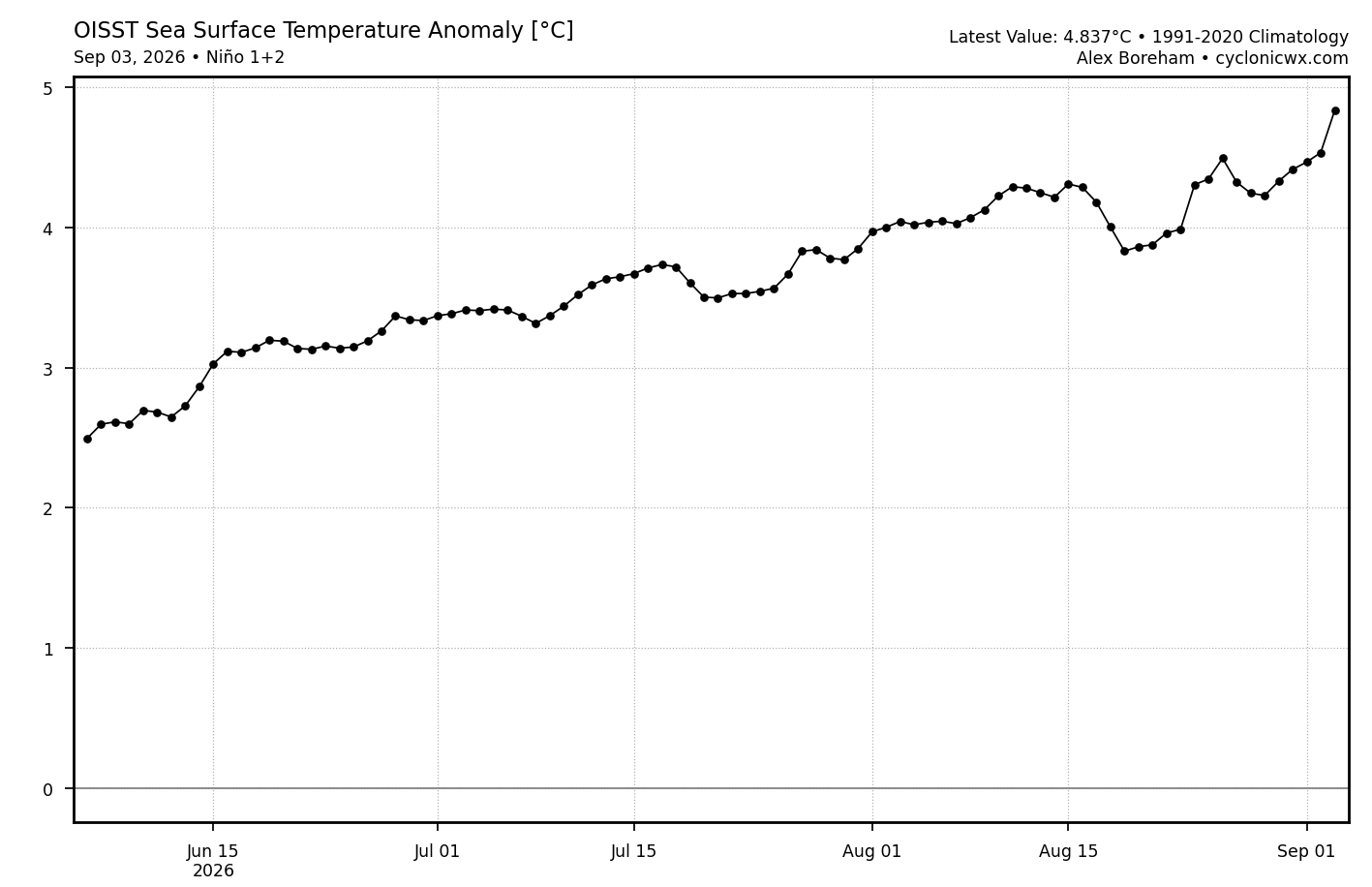
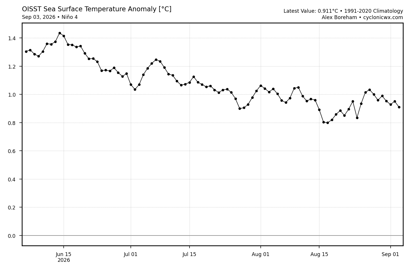
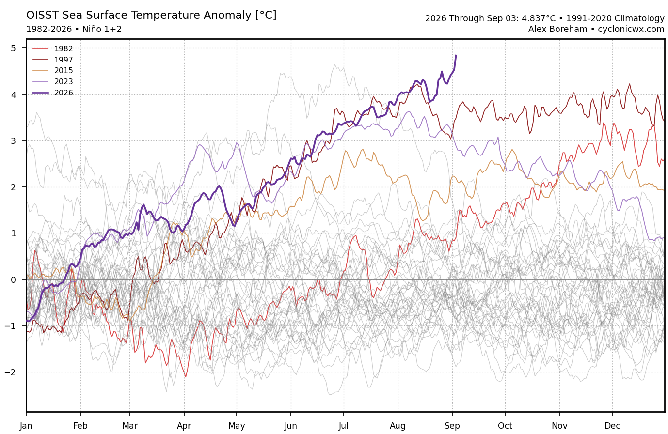
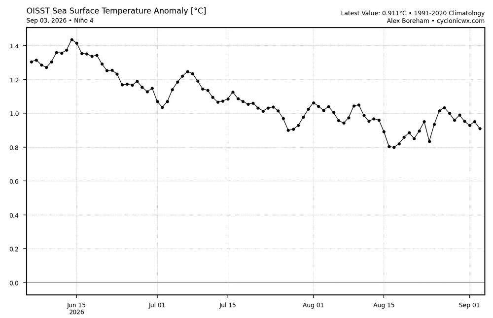
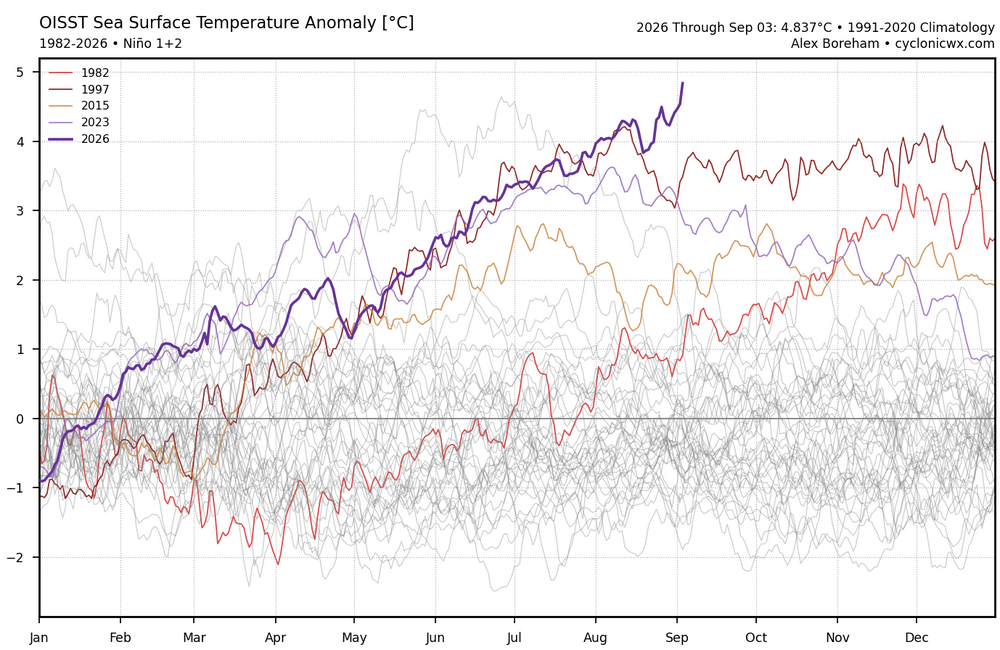
Models really missed how east based an event this has become. Not that big of a surprise since they can’t really can’t forecast the WWBs with that much precision beyond a week or two. This is the reason that Nino 3.4 leveled off in August and Nino 4 declined. It has resulted in the highest Nino 1+2 daily anomaly on record and it’s only early September.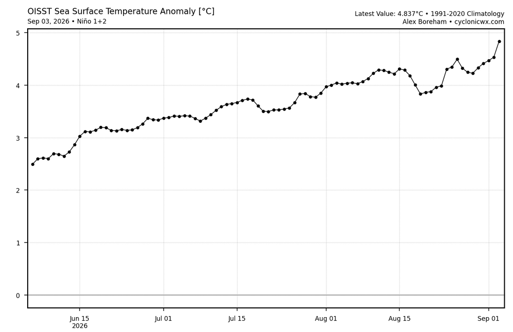
-

2026-2027 Record-breaking El Nino
mitchnick replied to Stormchaserchuck1's topic in Weather Forecasting and Discussion
I have children and grandchildren. Still don't worry about it. Like I said, too many other things imho that are going to "get us." lol -
Still a good bit of MLCIN over the DC/Baltimore area on mesoanalysis. DCAPE is not good NE of the Potomac essentially but ramps up quickly S/SW of there.
-
-

2026-2027 Record-breaking El Nino
Cobalt replied to Stormchaserchuck1's topic in Weather Forecasting and Discussion
Well yeah, because your generation won't be the one to see the worst consequences of such a temperature jump. -
Unless more north development occurs - most of us in Maryland are going to get missed. The bowing line segment now W of Romney is on track to go through NoVA - perhaps as far south as like Warrenton/Manassas. Even Loudoun/Fairfax may miss out.
-
Well it over tomorrow
-
2026-2027 Record-breaking El Nino
mitchnick replied to Stormchaserchuck1's topic in Weather Forecasting and Discussion
Name caller classic. -
Severe Thunderstorm Watch up until 9pm URGENT - IMMEDIATE BROADCAST REQUESTED Severe Thunderstorm Watch Number 653 NWS Storm Prediction Center Norman OK 205 PM EDT Fri Sep 4 2026 The NWS Storm Prediction Center has issued a * Severe Thunderstorm Watch for portions of District Of Columbia Eastern Kentucky Western Maryland Southeast Ohio Virginia West Virginia Coastal Waters * Effective this Friday afternoon and evening from 205 PM until 900 PM EDT. * Primary threats include... Scattered damaging wind gusts to 70 mph likely Isolated large hail events to 1.5 inches in diameter possible A tornado or two possible SUMMARY...Relatively widespread clusters of storms will continue to become increasingly common this afternoon, with the potential for storms to organize over time as they progress generally southeastward. Wind damage will be the most common hazard.
-
2026-2027 Record-breaking El Nino
mitchnick replied to Stormchaserchuck1's topic in Weather Forecasting and Discussion
I neither care nor worry about it. Plenty of other more important things in this world imho. -

2026-2027 Record-breaking El Nino
forkyfork replied to Stormchaserchuck1's topic in Weather Forecasting and Discussion
denier classic -

Fall 2026 Medium/Long Range Pattern Thread
dwagner88 replied to John1122's topic in Tennessee Valley
KCHA has been outdoing KMEM on heat indexes this week. That's rare. And very unwelcome. -
Mary Sheffield (Detroit's mayor) says the NWS informed her privately it was a tornado, although their final official public report along with the rating is still pending. This is the first tornado to touch down in Detroit proper since the historic July 1997 outbreak. At the very least, I'm thinking EF-1 (possibly EF-2).
-
2026-2027 Record-breaking El Nino
mitchnick replied to Stormchaserchuck1's topic in Weather Forecasting and Discussion
I don't deny earth's warming. I just don't believe it's the end of the world or unusual. -
2026-2027 Record-breaking El Nino
Cobalt replied to Stormchaserchuck1's topic in Weather Forecasting and Discussion
Normally waxing and waning isn't at a rate of 1C in 50 years. 5C was all the difference between glaciers over NYC and modern climo, and that took thousands of years. Not out of the question that we clear a similar gap within the next 100 years. -
2026-2027 Record-breaking El Nino
forkyfork replied to Stormchaserchuck1's topic in Weather Forecasting and Discussion
i didn't know climate change deniers like you still existed -

2026-2027 Record-breaking El Nino
Keith Central PA replied to Stormchaserchuck1's topic in Weather Forecasting and Discussion
No if you like warmer than normal, sure no doubt. Snow however is a totally different topic..look at 1983 and 2016 -
2026-2027 Record-breaking El Nino
mitchnick replied to Stormchaserchuck1's topic in Weather Forecasting and Discussion
Waxing and waxing of earth's temps. Nbd