All Activity
- Past hour
-
I hope this isn't a preview of summer. I'm just tired of these wild temperature swings. I'd much rather have it be one consistent temperature, whether it be the 90s, 80s, or heck, even 70s. But I can't do it if we're going to have runs in the 100s this summer, only to be followed by temps in the 50s soon thereafter.
-
The euro is absolutely horrendous. Hope that changes.
-

Occasional Thoughts on Climate Change
Typhoon Tip replied to donsutherland1's topic in Climate Change
Welp ..73 here as we near the 10am hour. "10 after 10" puts us in the 80s ... but being on the north side of a sag front that has observable site winds coming off the ocean. That says no...but, temps rising unimpeded as trend says yes. Minor competing signals there. I guess the wind being very light, in the 10kt range may not be enough. It's like you could work it out mathematically. Determine what the necessary E wind strength has to be during the solar max in order to overcome diurnal heating. I bet 10 kts isn't enough? Something like that. The shallow boundary is already apparently coming back as a warm front, according to WPC ... the previous update had this as a cool front where it is now warm in CT. I guess the late high T surge idea of the NAM has legs.
-
Nah its a holiday weekend so of course it will be a washout
-
Someone who knows his stuff ∆
-
Maybe a few rogue strong storms around later Tuesday. We'll see convection with the front on Wednesday but anything severe would be isolated and relatively brief. Would be more intriguing if lapse rates were a bit more respectable.
-
Some of that in Maine, but nearly all the panels are being installed on idle farmland. Only advantage comes when the panels' life are done - quicker to revert the land to farming than to create a mature forest.
-
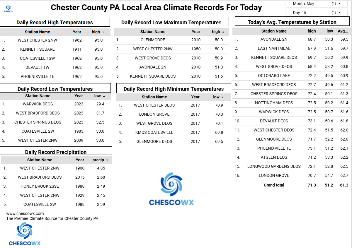
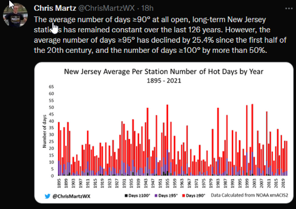
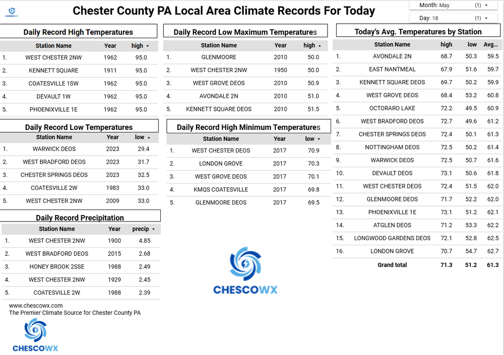
(002).thumb.png.6e3d9d46bca5fe41aab7a74871dd8af8.png) No cherry picking here as fortunately we have climate facts to fall back on - a quick look for example at when many of the records were set in 1936 the 9th and 10th were both 111 degrees at Phoenixville - even eliminating them still has Coatesville and West Chester at 105 and 104 degrees for records still occurring in the 1930's. Surrounding stations were also very hot. Of note the number of hot days across all of PA And NJ is in fact decreasing since the first half of the 20th century not increasing at all!!
No cherry picking here as fortunately we have climate facts to fall back on - a quick look for example at when many of the records were set in 1936 the 9th and 10th were both 111 degrees at Phoenixville - even eliminating them still has Coatesville and West Chester at 105 and 104 degrees for records still occurring in the 1930's. Surrounding stations were also very hot. Of note the number of hot days across all of PA And NJ is in fact decreasing since the first half of the 20th century not increasing at all!!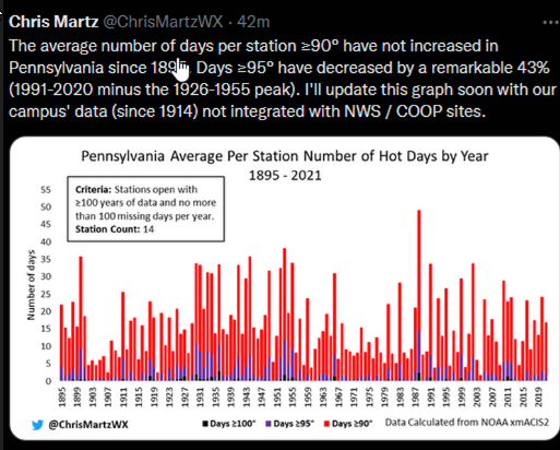
-
Yes the forecast sounding was meant for yesterday across the MS/LA Delta. I took this sounding from the HRRR from 5/16/26 and it actually showed a low end severe weather threat/maybe even a very low end tornado/landspout type day. Nothing really happened across the that area as storms struggled and some of the key parameters (not shown here) was not present for it to come to fruition. However, i think it’s cool to sometimes look at these lower end or even sub severe days to look for that diamond in the rough. As a side note, the morning of 5/17/26, the SPC did put out a marginal risk for severe storms which based on the forecast sounding was not a shocked.
-
May 18 1980: Mt. St. Helens erupts. The smoke plume eventually rises to 80,000 feet, circling the earth in 19 days. Brilliant sunsets due to the smoke are seen over Minnesota for days afterward. Note: I remember this as a kid. The skies were pretty obscure for a while. An older friend of mine was in the MT mtns when it happened. He was a Green Beret in Vietnam. He heard the explosions, and thought the W coast was coming under a B-52 attack. He had no idea it was an eruption. 1933: Tornadoes hit McLeod and Mower counties. For Monday, May 18, 2026 1825 - A tornado said to have crossed all of the state of Ohio smashed into the log cabin settlement of Burlington, northeast of Columbus. (David Ludlum) 1960 - Salt Lake City UT received an inch of snow. It marked their latest measurable snowfall of record. (The Weather Channel) 1980 - Mount Saint Helens in Washington State erupted spewing ash and smoke sixty-three thousand feet into the air. Heavy ash covered the ground to the immediate northwest, and small particles were carried to the Atlantic coast. (David Ludlum) 1987 - Thunderstorms in Kansas, developing along a cold front, spawned tornadoes at Emporia and Toledo, produced wind gusts to 65 mph at Fort Scott, and produced golf ball size hail in the Kansas City area. Unseasonably hot weather prevailed ahead of the cold front. Pomona NJ reported a record high of 93 degrees, and Altus, OK, hit 100 degrees. (The National Weather Summary) (Storm Data) 1988 - Low pressure anchored over eastern Virginia kept showers and thunderstorms over the Middle Atlantic Coast Region. Flash flooding was reported in Pennsylvania. Up to five inches of rain drenched Franklin County PA in 24 hours. (The National Weather Summary) 1989 - Thunderstorms developing ahead of a cold front produced severe weather from the Central Gulf Coast States to the Lower Missouri Valley during the day and evening. Thunderstorms spawned sixteen tornadoes, and there were 74 reports of large hail and damaging winds. (The National Weather Summary) (Storm Data) 1990 - Thunderstorms produced severe weather in the central U.S. spawning a sixteen tornadoes, including a dozen in Nebraska. Thunderstorms also produced hail four inches in diameter at Perryton TX, wind gusts to 84 mph at Ellis KS, and high winds which caused nearly two million dollars damage at Sutherland NE. Thunderstorms deluged Sioux City IA with up to eight inches of rain, resulting in a record flood crest on Perry Creek and at least 4.5 million dollars damage. (The National Weather Summary) (Storm Data)
-
par for the course. also makes me wonder if the weekend ends up drier
-
snow reported at the cities in central/southern Wyoming and also here at RMNP:
-
Looking at NYC and other (somewhat shorter record) sites, I'd put the mid-60s as the driest in a century or more.
-
Ho man. The wonder of weather, snuffed out. we joke but there will be a weather modification future. It's just too intuitively easy to see that. Quantum Computing is basically going to expose at some point, how to force "the quantum computing of the cosmos" - so to speak. That is, in any future where human tech does not stop the the future from taking place before getting there - oh yeah..that. I mean just recall synoptic II and learning how/why chaos will never allow modeling to be very precise beyond whenever. Can't stop the spontaneity of emerging future feedbacks blah blah the prediction unavoidably gets corrupted. Well, the easy antidote is ...don't try to predict that then. Control it. It seems quantum scale perturbation is a realm where actual Quantum Computing might be uniquely adapted to handle. Control being apropos. Seems that way anywho
-
0.19" of rain last night. Very meager from what was expected. Cool, drizzly, foggy morning. Fire is 62% contained with 34 structures destroyed. Should be about done by tomorrow.
-
Is the severe threat for late Tuesday and Wednesday not worth mentioning?
-
Central PA Spring 2026 Discussion/Obs Thread
ChescoWx replied to Voyager's topic in Upstate New York/Pennsylvania
A hot start to the week with our warmest day tomorrow before a sharp chill down by Memorial Day weekend. Many valley locations could touch 90 degrees both today and for sure tomorrow. Some higher ridges may fall a bit short of 90 both days. By Thursday temperatures should be at least 20 degrees cooler than Wednesday. In fact, while the current NWS forecast has highs in the mid 60's both Friday and Saturday I suspect much of Chester County will struggle to get out of the chilly 50's both Friday and Saturday. Shower chances increase on Wednesday with shower chances continuing through the weekend.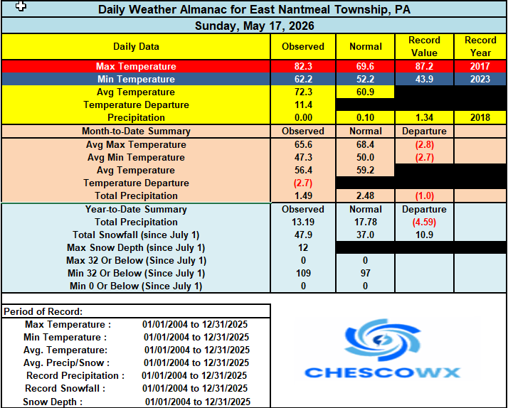
-
E PA/NJ/DE Spring 2026 Obs/Discussion
ChescoWx replied to PhiEaglesfan712's topic in Philadelphia Region
A hot start to the week with our warmest day tomorrow before a sharp chill down by Memorial Day weekend. Many valley locations could touch 90 degrees both today and for sure tomorrow. Some higher ridges may fall a bit short of 90 both days. By Thursday temperatures should be at least 20 degrees cooler than Wednesday. In fact, while the current NWS forecast has highs in the mid 60's both Friday and Saturday I suspect much of Chester County will struggle to get out of the chilly 50's both Friday and Saturday. Shower chances increase on Wednesday with shower chances continuing through the weekend.
-

2026-2027 Strong/Super El Nino
PhiEaglesfan712 replied to Stormchaserchuck1's topic in Weather Forecasting and Discussion
Yeah, that 2018-20 period was a disjointed at best. We didn't really have a definitive ENSO or PDO state during those years (the PDO was near neutral for the greater part of almost 4 years after the mid-2010s el nino dissipated), until we got to 2020-21, which was a solid la nina and -PDO. -
60° every Christmas morning for safe travel!
-
Already 74° with a projected high of 74.
-
Central MD special Now if only I trusted the RGEM at this range more.
-
Wednesday's front not looking like it will have much rain with it
-
i’ll take whatever rain we can get whenever we can get it at this point


.thumb.jpg.049f4a7f726ada07e8cd30bd17e713cb.jpg)