All Activity
- Past hour
-
 For you, Aldie, and me....
 -

E PA/NJ/DE Winter 2025-26 Obs/Discussion
Violentweatherfan replied to LVblizzard's topic in Philadelphia Region
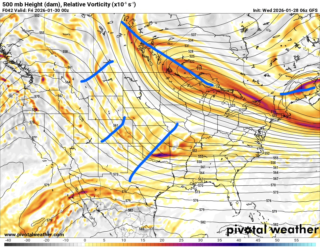
On the video I posted there is mention that the precipitation field should be more expansive. Yeah there will be sharp gradients but the field should be further west -

The “I bring the mojo” Jan 30-Feb 1 potential winter storm
ncforecaster89 replied to lilj4425's topic in Southeastern States
That’s a good first call map, IMO, and I like the more cautious (and responsible) approach. The only tweak I’d make would be a simple mention of “higher localized amounts possible” in your 6-10” zone. It’s obviously still a little early for such specifics, but I’ll be surprised if some areas don’t see a foot. -
NY metro is the weakest forum of the 3 major ones. Like 5 or 6 regular mets.
-

Possible coastal storm centered on Feb 1 2026.
CoastalWx replied to Typhoon Tip's topic in New England
I think that was like 2 days later? I recall that. -

January 2026 regional war/obs/disco thread
radarman replied to Baroclinic Zone's topic in New England
Saw a -15 and a bunch of -12s and -13s in the best radiating spots in S Belchertown/ Ludlow. Sensor caveats apply. But the elevated spots weren't close to that, 0 to maybe a couple degrees below. Not totally fake cold, just kinda fake. -

The “I bring the mojo” Jan 30-Feb 1 potential winter storm
Buddy1987 replied to lilj4425's topic in Southeastern States
NAM is off and running. Close enough to it's medium range it may start to matter, at least when reviewing 5h panels. -

Possible coastal storm centered on Feb 1 2026.
dendrite replied to Typhoon Tip's topic in New England
There’s a late shitstreak that drops south toward New England that keeps the heights suppressed a little longer than they would be otherwise. That PV lobe is pivoting and dropping southeast at this point and the heights (that string of vorticity over us) really wants to move north more if that other s/w wasn’t there. Maybe in the end it wouldn’t matter, but anything that can relax the gph field I’d think would be a benefit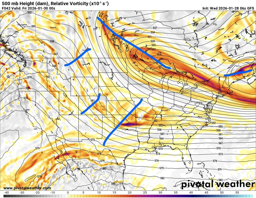
-

January 2026 regional war/obs/disco thread
WinterWolf replied to Baroclinic Zone's topic in New England
Stop whining…this is winter. Embrace. Enjoy. New England at its finest right now. This is what you moved up here for. -

The Jan 31 Potential: Stormtracker Failure or 'Tracker Trouncing
frd replied to stormtracker's topic in Mid Atlantic
Jim Cantore@JimCantore · 38m An east coast storm will evolve over the weekend as jet streams phase together to create very deep low pressure off the east coast. This is a whole different animal than the last storm, but COASTAL IMPACTS like COASTAL FLOODING, OVERWASH, and BLIZZARD are all still in play especially the 757 and eastern NC as well as Cape Cod and the Islands. At this time it appears most of the worst impacts could be east of i95. This does not mean there won't be snow in parts of the southeast as the upper parts of the storm create lift and pump out lighter snows across the Mid-South and the Mid-Atlantic. Even some areas that are dealing with crippling ICE and power outages can see some SNOW. Various models still have a variety of solutions so there is still a lot of fine tuning to go. All these low positions below are for 12z (7am) Sunday morning. -
Don’t want to be debbie downer but most of you do realize there is always a screw zone on the NW flank of these coastal systems, right? I don't think anyone knows where that will be at this time. My guess would be west of 77
-

Possible coastal storm centered on Feb 1 2026.
Typhoon Tip replied to Typhoon Tip's topic in New England
It makes sense of itself ... which is not an aver as to it's winning in this thing, but given the larger super synoptic structure wrt ridge and troughs and teleconnectors therein, that is what this should all be looking like. Rather elegantly, too The CFS - I believe but am not certain - is a climate fusion with GFS output. It's possible the the climate integral part of that is pulling these E solutions of the operational GFS, back W where they really should be - given to the aforementioned synoptic arguments. Interesting... -
Yes, during the second half of February, PNA- is better for significant or major snowfalls due to the shortening of wave lengths.
-

The “I bring the mojo” Jan 30-Feb 1 potential winter storm
ADB83 replied to lilj4425's topic in Southeastern States
Each of the last 3 runs of that model have trended toward that solution . -

Possible coastal storm centered on Feb 1 2026.
Baroclinic Zone replied to Typhoon Tip's topic in New England
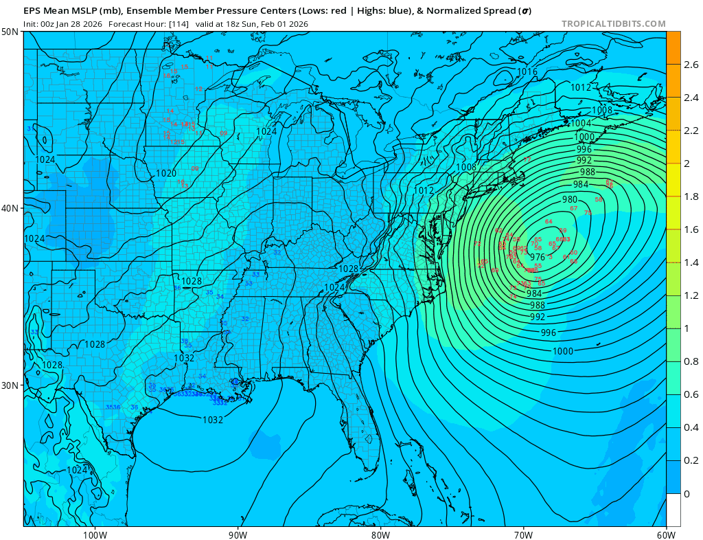
Pretty solid GEFS/EPS clustering from 06z runs. Not a bad look verbatim for the most hated subsection of the forum. -

The Jan 31 Potential: Stormtracker Failure or 'Tracker Trouncing
ecrugger replied to stormtracker's topic in Mid Atlantic
Ok, I need someone to make a case for me explaining why I'm not going to get at least 6 inches of snow in Chesapeake/Virginia Beach. -

Possible coastal storm centered on Feb 1 2026.
ScituateWX replied to Typhoon Tip's topic in New England
Getting a new cutting edge tomorrow! -

The Jan 31 Potential: Stormtracker Failure or 'Tracker Trouncing
BristowWx replied to stormtracker's topic in Mid Atlantic
Our location is sooo close to something or nothing. Gotta stay vested at least until Saturday. -
Possible coastal storm centered on Feb 1 2026.
dendrite replied to Typhoon Tip's topic in New England
I noticed a subtle trend with that too. The vortmax may dig for oil just the same, but if we can tick everything a little west we can swing the system closer our way as it gains latitude. I’d like to see some of the late suppression over New England back off a bit late week to help the heights recover over the weekend. -
Yes. I just was thinking the same thing.
-

1-30/2-1-26 Arctic Blast, ULL Snow Event
Carvers Gap replied to John1122's topic in Tennessee Valley
The closer to the spine of the Apps that one lives and north of I40.....that is the sweet spot for now. BTW, that is not me. I am roughly in the same boat as Knoxville in hoping for storm trends. I am on the far west side of TRI.- 28 replies
-
- 1
-

-
- extreme cold
- snow
- (and 1 more)
-
Great video of the ice flows in the Hudson River.
-
E PA/NJ/DE Winter 2025-26 Obs/Discussion
Violentweatherfan replied to LVblizzard's topic in Philadelphia Region
This is great discussion, but the info from late last night’s runs aren’t included