All Activity
- Past hour
-
If we get a low to cut off by Ohio like some models are suggesting I think we have a chance.. even if it's slim
-

E PA/NJ/DE Summer 2025 Obs/Discussion
PhiEaglesfan712 replied to Hurricane Agnes's topic in Philadelphia Region
No, thank you. My area is fine, and hasn't been in a drought since about March 5. (I told you after the Eagles Parade, when I saw mud, that the drought was almost over. Lo and behold, three weeks later, we got the rain event that was the beginning of the end of the drought.) I don't want a hurricane. I'd be okay with some T-storm events (like 7/31, and that wasn't long ago), but a hurricane would be overboard, and probably put my area in a flooding situation. -
Weed and grass growth has stopped here entirely. It’s dry.
-
I have not but have always wanted to. I believe it is a Donald Ross design.
-
 And in 5 years these departures are going to be -4 and we are going to be saying oh wow look how cold it was meanwhile 5 years ago these were all closer to -2.x
 -
Probably 'false' foliage season is the better description.
-
I'll be just like everyone else in the winter says, I'm sure the moose won't care how hot it gets.
-
Same for NE MA...summer is usually a borefest but this one has been the dullest summer ever...
-
Here's a completely random question......what town was Messenger from again? I know it was on the south coast somewhere.
-
Unfortunately that is true.
-
It’s all he’s got. For some, bad publicity is better than no publicity.
-
 Through 8/10 Monthly Aug Departures EWR: -3.2 NYC: -3.2 JFK: -3.5 LGA: -3.9
 -
There is always that super low percentage it happens but like you said, there is a very specific and clear pattern to get these up the coasts. There is a reason why they are infrequent and the return rate is in the years. I get looking the extended range SLP or snow maps or whatever is fun but having an understanding of the current pattern in place and how the pattern will evolve will give you tremendous insight as to what you can expect will unfold in the extended range (there are exceptions of course).
-
6Z Eur has 0.25 - 0.50 (ish) overnight Wed / Thu.
-
All I know is if Canada steals another one I’m going to jump into the Atlantic
-
If that thing ever came between, let’s say NYC and Nantucket then I’ll give credit with credit is due. I always do. I’m just not really seeing that right now. Look at all that Northwest flow from Maine down to Nova Scotia at 500.
-
Records: Highs: EWR: 102 (1949) NYC: 102 (1944) LGA: 99 (1949) JFK: 99 (1949) Low: EWR: 56 (1972) NYC: 56 (1962) LGA: 57 (1962) JFK: 57 (1962) Historical: 1928: At 24th & M DC - Washington set a record of 7.31 inches of rain in 24 hours. East Coast Storms (Ref. AccWeather Weather History) 1933: The shade temperature reached 136.4° at San Luis, Mexico, to unofficially share the world record with Aziziyah, Lybia. (Ref. Wilson Wx. History) 1936: The warmest August temperature ever recorded in both Oklahoma City and Wichita Falls occurred on this date. The morning low in Oklahoma City was a warm 82°, before both cities warmed up to a very hot 113°. The old August record in Oklahoma City was 112, which was set the day before. In Wichita Falls, this record was tied on 8/6/1964. (Ref. Wilson Wx. History) 1940 - A Category 2 hurricane struck the Georgia and South Carolina coast. A 13-foot storm tide was measured along the South Carolina coast, while over 15 inches of rain fell across northern North Carolina. Significant flooding, the worst since 1607, and landslides struck Georgia, North Carolina, Tennessee, and Virginia during the system's slow trek as a weakening tropical storm, and then as an extratropical cyclone, through the Southeast. The landslides which struck North Carolina were considered a once in a century event. Damages relating to the storm totaled $13 million (1940 USD), and 50 people perished. 1944 - The temperature at Burlington, VT, soared to an all-time record high of 101 degrees. (The Weather Channel) The Dog Days officially come to an end on this date, having begun the third day in July. Superstition has it that dogs tend to become mad during that time of the year. (The Weather Channel) 1968: A young girl in a lake was injured when a dust devil near Bristol, CT carried a 150 pound roof covering a picnic area into a lake. (Ref. AccWeather Weather History) 1974: Illinois--Lightning struck and killed a boy who was hunting in Jersey County. (Ref. Lightning-The Underrated Killer.pdf) 1975: A line of heavy thunderstorms moved rapidly across portions of eastern South Dakota and into Iowa. In Canton, winds were estimated at 70 mph while the National Weather Service in Sioux Falls was belted with a 69 mph gust. The high winds leveled many trees and also destroyed some older buildings in Miner County while the Sioux Falls area had only tree damage and minor building damage. The storms maintained their strength as they moved into northwest Iowa. An uncompleted trucking terminal and several trucks received around $10,000 dollars in damage in Sac County while a grain storage bin was flattened and boat house destroyed near Storm Lake. (Ref. Wilson Wx. History) 1979: The mercury was plummeting over portions of the Arrowhead of Minnesota. The temperature at Embarrass, MN fell to 28°, accompanied by a hard freeze. (Ref. AccWeather Weather History) 1980 - Clouds and moisture from Hurricane Allen provided a brief break from the torrid Texas heatwave, with daily highs mostly in the 70s to lower 90s. (The Weather Channel) 1984: Dulles Airport records 11 inches of rain in 24 hrs. (Ref. Dulles Weather Records) (Ref. AccWeather Weather History) Miami, FL set a record high for the date with 96°. Then a thunderstorm cools things off to 70°, which set a record low for the date. (Ref. Wilson Wx. History) 1986: Atlanta, GA saw its streak of 38 consecutive days with 90 degrees or hotter finally come to an end with a reading of 89 °F. (Ref. AccWeather Weather History) 1987 - An early evening thunderstorm in Wyoming produced hail up to two inches in diameter from Alva to Hulett. Snow plows had to be used to clear Highway 24 south of Hulett, where hail formed drifts two feet deep. (The National Weather Summary) 1988 - Moisture from what remained of Tropical Storm Beryl resulted in torrential rains across eastern Texas. Twelve and a half inches of rain deluged Enterprise TX, which was more than the amount received there during the previous eight months. Philadelphia PA reported a record forty-four days of 90 degree weather for the year. Baltimore MD and Newark NJ reported a record fourteen straight days of 90 degree heat. (The National Weather Summary) 1989 - One of the most severe convective outbreaks of record came to a climax in southern California after four days. Thunderstorms deluged Benton CA with six inches of rain two days in a row, and the flooding which resulted caused more than a million dollars damage to homes and highways. Thunderstorms around Yellowstone Park WY produced four inches of rain in twenty minutes resulting in fifteen mudslides. Thunderstorms over Long Island NY drenched Suffolk County with 8 to 10 inches of rain. Twenty-three cities in the southeastern U.S. reported record low temperatures for the date. It was, for some cities, the fourth straight morning of record cold temperatures. (The National Weather Summary) (Storm Data) 1993: Ashley National Forest, Utah: A tornado strikes in the Uinta Mountains, 20 miles northeast of Roosevelt, Utah. It demolishes 1,000 acres of trees in the Ashley National Forest at 10,800 feet above sea level. (Ref. WxDoctor) 1999 - An F2 tornado touched down in the metropolitan area of Salt Lake City. The tornado lasted ten minutes and killed one person, injured more than 80 people, and caused more than $170 million in damages. It was the most destructive tornado in Utah's history and awakened the entire state's population to the fact that the Beehive State does experience tornadoes. 2001: A woman was struck and killed by lightning while on a boat in the Chesapeake Bay near the Oceanview section of Norfolk, VA. An Amherst, VA woman was struck by lightning and received minor injuries. (Ref. Lightning - Virginia Weather History) 2002: The National Weather Service at North Platte, NE reported huge 7 inch hail three miles east of Halsey, NE. (Ref. Wilson Wx. History) 2004: Wisconsin: A cold air mass descends over Wisconsin. Ten cities report maximum temperatures that are among the coldest ever for the month. Three break old records, two tie records and five record second lowest maximum temperature. High temperatures range from 52°F in the north to 59°F in southern part of the state. (Ref. WxDoctor) 2007: Dutch Harbor, AK set their all-time high temperature with a reading of 81°. (Ref. Wilson Wx. History) 2016: August 9-16. Weak low pressure combined with abundant Gulf moisture produced phenomenal rainfall and flooding across central Louisiana, inundating entire neighborhoods and towns, especially around Lafayette and Baton Rouge. Rainfall totals exceeded 20 inches in as little as two days. Thirteen people died and economic costs ranged from $10 to $15 billion.
-
Some people forget or don't understand that weather forecasting is way more than just looking at the solution of a model output.
-
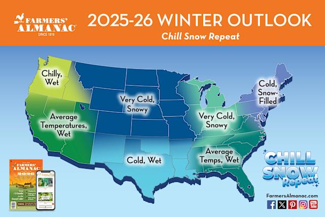
Farmer's Almanac winter forecast: Lock it in!
-
Good morning and thank you Liberty. My strength is still knowing how to use a calculator and being retired having plenty of time to use it. Stay well , as always …..
-
THIS!!! There is a very clear pattern that brings the storms up the coast to do damage. This is not even close to it.
-

Central PA Summer 2025
Mount Joy Snowman replied to Voyager's topic in Upstate New York/Pennsylvania
Low of 59. Today should mark 11 straight days of negative departures for MDT before things turn around for the foreseeable future tomorrow. Onward. -
I just don't get it. Why would you want to shed yourself in that light?
-
That was a spectacular weather weekend. Did whitewater tubing on Saturday at Harper's Ferry and I cannot imagine a better summer day for that. Two hikes with the dogs yesterday. Such deep blue skies, summer hot but not, HOT, humidity more than tolerable. Just a superlative set of weather days.
-

Central PA Summer 2025
TheClimateChanger replied to Voyager's topic in Upstate New York/Pennsylvania
Yes, those were noted in this thread.


