All Activity
- Past hour
-
Thanks. I realize that the RDU sensor is often a hot spot under sunshine in the warm season per past discussions I’ve read here and elsewhere. Do you know if your house had temps that jumped around ~6 F within just a few minutes of 3 PM? That seems very high with mostly sunny skies and no wind shift!
-
33° at Estcourt Station. Some mid 30s in N NH and W ME too.
-
Replaced my rain gauge yesterday. Right on cue.
-
48 at the house this morning. That’s it for a while
-

Central PA Summer 2026 Discussion/Obs Thread
TheDreamTraveler replied to Voyager's topic in Upstate New York/Pennsylvania
Today should be pretty nice -

2026 Atlantic Hurricane Season
A-L-E-K replied to Stormchaserchuck1's topic in Tropical Headquarters
zzzzzzzzz -
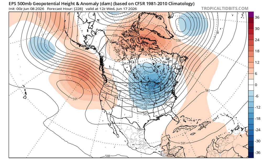
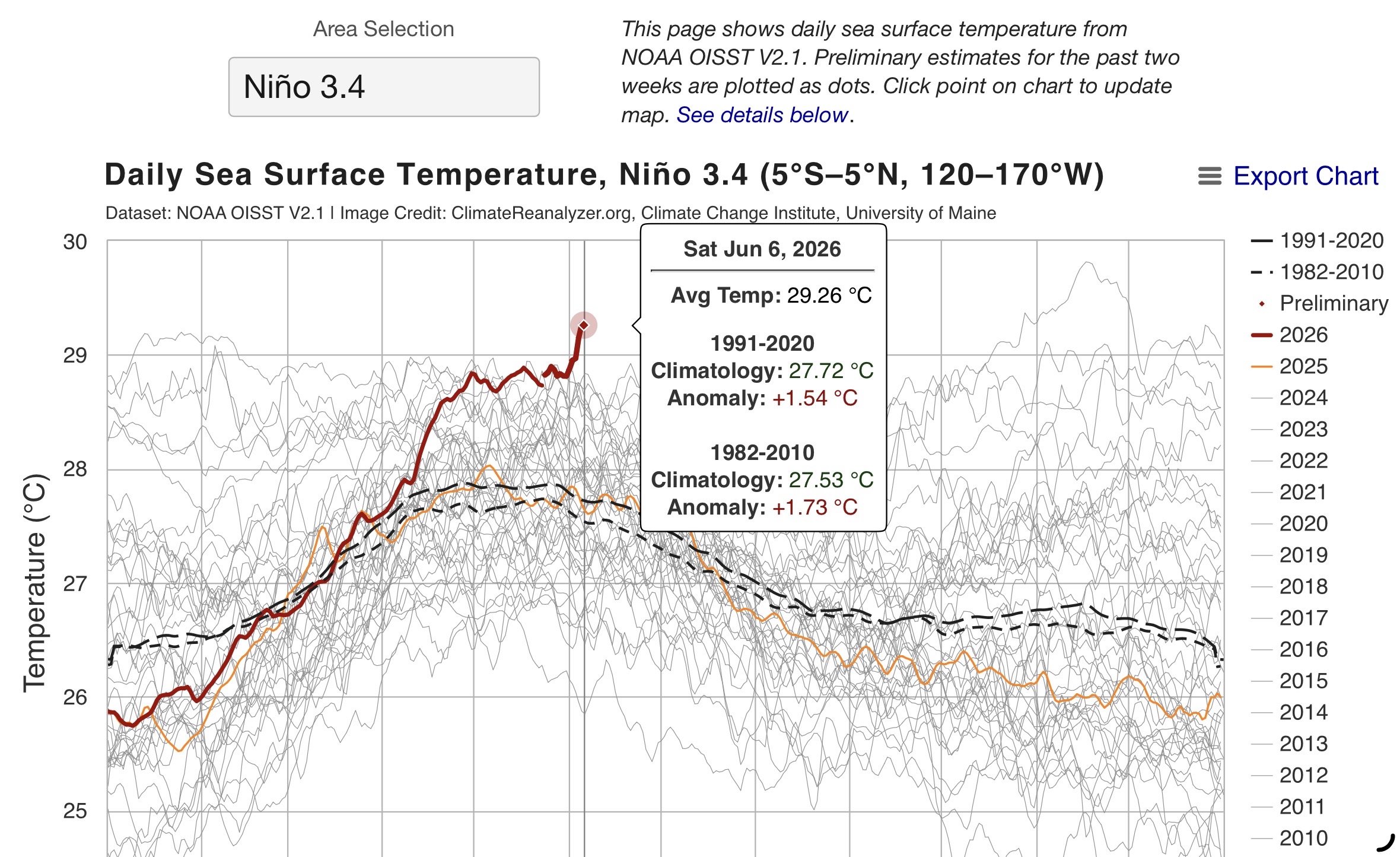
Looks like some cooler and hopefully wetter weather is on the way for next week following more unusual warmth this week for a developing El Niño. A ridge out West and a trough near the Great Lakes is a closer match to El Niño June expectations. It’s forecast to occur right as this event is setting records for the warmest Nino 3.4 SST on record for early June.

-
We hit 97.2 at my house so not super far fetched but highest in the state for sure
-
Min 47.7° Hopefully some rain midweek
-
While doing some yard clean up yesterday from the storm my grandson saw me raking and said “Fall!”, not yet buddy. So glad I cleaned up in the morning because yesterday afternoons winds blew down the down stuff that was still hung up in the trees…oh well, it doesn’t look as bad it as did.
-

Central PA Summer 2026 Discussion/Obs Thread
mahantango#1 replied to Voyager's topic in Upstate New York/Pennsylvania
- Today
-

2026-2027 Super El Nino
bluewave replied to Stormchaserchuck1's topic in Weather Forecasting and Discussion
November 2026 hasn’t occurred yet. So this past November was in 2025. Part of the reason this El Niño is becoming record breaking so early on is due to the accumulation of record SST warmth in the WPAC. The WWBs beginning in November 2025 started the kelvin waves and warm push eastward. These are record breaking WWBs that we haven’t seen since the late 1990s. So a record WPAC warm pool initiation plus record WWBs equal a record El Niño. Also note how Nino 1+2 never fully cooled off after the last super El Niño in 2023-2024. So it’s no surprise that this event is becoming so strong given the much warmer background state that it’s originating in. Past climate reconstructions along with modeling support the hypothesis that it’s normal for El Niños to become more frequent and stronger as the world warms. So the 2020s will be the first decade with super El Niños over +2.0° occurring only 3 years apart. Plus recent studies show that at some point in the future we can warm enough to enter a sustained El Niño climate. But we really don’t know the global temperature threshold at which this could theoretically occur. Still uncertain if this could even occur in a modern warmer climate or the stronger and more frequent El Niño mode continues to dominate over some La Niña intervals in between. https://apnews.com/article/4379af505f994766a4fa332e9c7a923a https://www.colorado.edu/today/2024/09/25/1-2-el-nino-events-could-be-extreme-mid-century https://www.science.org/doi/10.1126/science.354.6317.1210 https://esd.copernicus.org/articles/10/631/2019/ -
He just looks at colors
-
What an amazing morning! Crisp and refreshing and the pollen has been (probably temporarily) washed away.
-
Central PA Summer 2026 Discussion/Obs Thread
mahantango#1 replied to Voyager's topic in Upstate New York/Pennsylvania
The most studied? -
9:15pm Saturday evening:
-

Central PA Summer 2026 Discussion/Obs Thread
pawatch replied to Voyager's topic in Upstate New York/Pennsylvania
85 degrees for the high yesterday. 54 degrees for the low this morning. Appears it’s going to be a hot and humid week on tap. -
Enjoyed the gv today lets do it again tomorrow
-

Texas 2026 Discussion/Observations
Stx_Thunder replied to Stx_Thunder's topic in Central/Western States
While things (might) be quieter for most of this new week, it's looking more likely now to start picking back up for mid June. More late spring type (northwest upper-flow) troughing, and MCS activity are bound to track through the state. Severe potential is there once again also. As models are trending up on shear values and steepening ML lapse rates further south in the state, into next week of June 15th. EN has certainly been making its presence known lately with no dominant summertime subtrop ridging around yet still, to actually push southern-stream jet influence away. Which continues to make things more interesting. Possibly even late June also. Which would be getting really late for that transition. -
KEY MESSAGE 2...Increasing heat and humidity this week with afternoon thunderstorm chances Wednesday through Friday. Summerlike heat and humidity return this week as an anomalous mid- level ridge and surface high pressure expand into the region. Tuesday kicks off the warming trend, with 850 mb temperatures climbing into the middle to upper teens, supporting daily afternoon highs in the upper 80s to lower 90s. NWS HeatRisk guidance highlights the potential for heat impacts, with widespread moderate impacts and isolated pockets of major impacts, particularly across urban centers by late week. One possible fly in the ointment will be cloud cover and storm coverage during the middle to latter half of the week, which could keep temperatures just cool enough to avoid the need for heat-related headlines. Nevertheless, those who work outdoors should prepare for another stretch of unseasonably warm temperatures. Additionally, there will be little in the way of nighttime relief, with overnight lows generally remaining in the 60s.
-
Nice rains yesterday! I was wrong but glad to be wrong
-
Fake news from RDU??TODAY MAXIMUM 99 259 PM CLI from KRAH ——————-NORTH CAROLINA WEATHER ROUNDUP NATIONAL WEATHER SERVICE RALEIGH NC 300 PM EDT SUN JUN 07 2026 RALEIGH-DURHAM MOSUNNY 93 57 29 VRB3 29.93F RWR from KRAH ——————-So, the 99 high was recorded at 2:59PM whereas the 3PM hourly reading was only 93. Sure, yeah right. This is truly bizarre! And the 99 seemed too high when considering surrounding stations!
-

2026-2027 Super El Nino
snowman19 replied to Stormchaserchuck1's topic in Weather Forecasting and Discussion
The EPAC has come alive….invests/convection galore. I think this has a very good chance of being a historic TC season in the EPAC -
So you should be through at least Tuesday. Maybe Wednesday if you get some clouds.
-
Nice. Surprised the rain pushed this far south and west. Lawn getting a decent drink 2 days in a row.


.thumb.gif.f92b16c631a1d15d405ed77b33f0710d.gif)

