All Activity
- Past hour
-
Ai has crushed the OPs actually
-

E PA/NJ/DE Winter 2025-26 Obs/Discussion
BBasile replied to LVblizzard's topic in Philadelphia Region
Sun Angle... -

February 2026 OBS & Discussion
WeatherGeek2025 replied to Stormlover74's topic in New York City Metro
Radar is back just in time for the big blizzy lol -
On January 14th we had a 30%-50% chance of snow showers, expecting a dusting, and ended up with 6.2" of snow by the morning of the 15th.
-

E PA/NJ/DE Winter 2025-26 Obs/Discussion
LVblizzard replied to LVblizzard's topic in Philadelphia Region
Sun angle is much higher than in December which makes it feel warmer and more like spring. That’s my guess anyway. -

Wednesday Feb 18 Mixed event. NOPE …ain’t happenin’
ORH_wxman replied to HoarfrostHubb's topic in New England
What idiot started this thread? -
Earlier today, this wide-ranging storm system was strung out WNW-ESE across the continent. It's pulling itself apart. Strange U-shaped snow forecast coming up for tomorrow. Also note: the Sierra Nevada is going to get a precipitation total of about 6" (60"+ of snowfall) out of this multi-day weather event.
-

Wednesday Feb 18 Mixed event. NOPE …ain’t happenin’
The 4 Seasons replied to HoarfrostHubb's topic in New England
-
Umm... sure
-
lol... At this point, I'd be happy to settle for a layup 2"
-
That was the joke - Jerimoth is RI's Mount Washington. I believe Mt. Jefferson is the second or third highest mountain in NH.
-
Same here. 5” in play. Just goes to show how there’s still plenty of surprises even with modern technology.
-
Looks almost as good when we got it bank in January lol
-
E PA/NJ/DE Winter 2025-26 Obs/Discussion
BBasile replied to LVblizzard's topic in Philadelphia Region
Why is that? Nobody is surprised about a thunderstorm in September. -

Pittsburgh/Western PA WINTER ‘25/‘26
colonel717 replied to Burghblizz's topic in Upstate New York/Pennsylvania
Maybe some thunderstorms tomorrow night.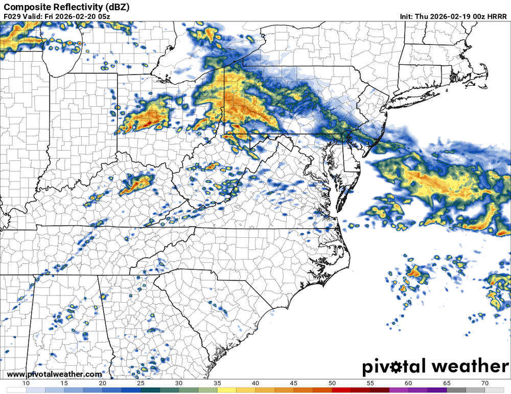
-

Pittsburgh/Western PA WINTER ‘25/‘26
Rd9108 replied to Burghblizz's topic in Upstate New York/Pennsylvania
Ill take a few inches to pad the total. If its gonna be cold might as well snow. -

Feb 22nd/23rd "There's no way..." Storm Thread
Weather Will replied to Maestrobjwa's topic in Mid Atlantic
WB 0Z NBM para...this looks all too familiar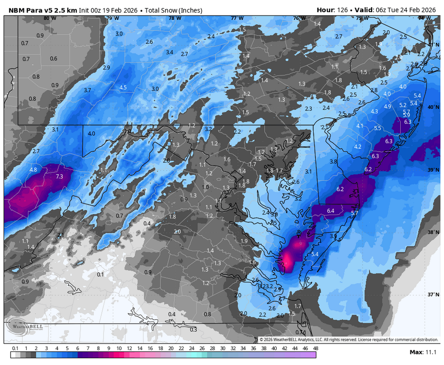
-
“Cory’s in NYC! Let’s HECS!” Feb. 22-24 Disco
The 4 Seasons replied to TheSnowman's topic in New England
i've noticed that with other storms like Jan 25-26th but isn't always the case like Jan 18-19th, they latched on to that earlier than OPs -
E PA/NJ/DE Winter 2025-26 Obs/Discussion
LVblizzard replied to LVblizzard's topic in Philadelphia Region
It’s crazy how so many people are always surprised when it snows well into March. Yes it’s not meteorological winter anymore, but historically it’s a snowier month than December. -

“Cory’s in NYC! Let’s HECS!” Feb. 22-24 Disco
weathafella replied to TheSnowman's topic in New England
He brings a ruckus to the ladies! -
Got a shower moving through, 39F. Been awhile since I’ve heard rain falling.
-
the 12Z and 18Z EPS gave RDU about a 30% chance of a trace of snow on Monday/Tuesday.
-
Deep breaths .
-

Wednesday Feb 18 Mixed event. NOPE …ain’t happenin’
ineedsnow replied to HoarfrostHubb's topic in New England
atleast I got to see snow fall for 30 minutes or so today.. it was melting instantly though on pavement -
Pittsburgh/Western PA WINTER ‘25/‘26
colonel717 replied to Burghblizz's topic in Upstate New York/Pennsylvania
Yeah, not expecting more than a couple inches at best. Probably grass only accumulation at that. Will see if all of the recon data makes a difference. If so it should tell us for 0z runs.