All Activity
- Past hour
-
Yes this is why I love our weather vs northern areas and especially New England. We don't have a mud season here and our climate is much closer to what it's like on the Jersey Shore.
-
I hopefully will. I think all the nonsense is behind me. I've accepted that you can't be a zionist on this board without ultimately being banned, and that antisemitism isn't policed. These things are complicated and OT is nothing but trolls and idiots. That said, don't go after Randy. It isn't on him. He can't sit and monitor every thread. He doesn't have an antisemitic bone in his body.
-
Maybe a helmet as well?
-
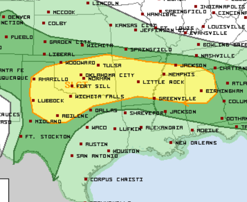
SPC is talking outflow boundary isolated tornadoes both Saturday and Sunday. The Saturday boundary and outlook is south of most of us, as expected with a morning through midday MCS. Sunday is below. Smaller morning MCS is forecast, and it could break up and allow redevelopment Sunday afternoon. Monday could be similar. While it's 3 days in a row it's Marginal-Slight, so not a huge deal. Still I find it quite interesting so late in the season. Sunday is below, updated Friday afternoon.
-
It’s actually not too bad currently at jones beach, almost full sunshine. Significantly better then this morning.
-
Oh good, more rain moving in.
-
heard that. long range looks promising... didn't think i'd have to say that between march and november
-
-
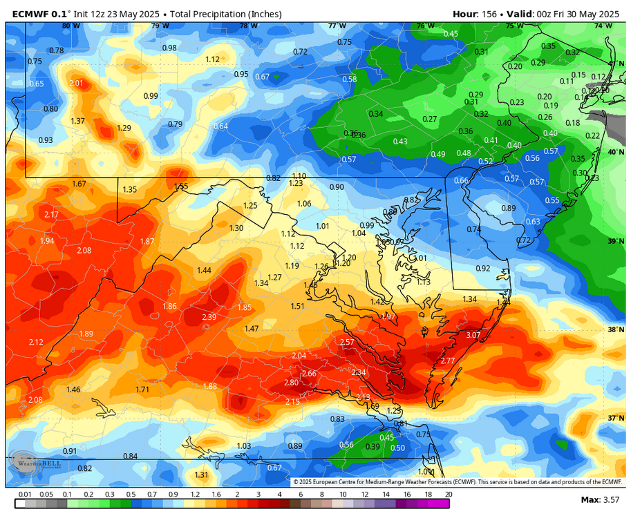
Most of the higher totals are to the South. A winter pattern.
.gif.0e63b9cdbe42594318c1f588858230f5.gif)
-
It would be in the upper 20s/low 30s in January rn…and I’m glad it’s not.
-
These stuck weather patterns are the bane of my existence. It helps with sleeping though because #depression. I see NYC beaches open this weekend... Ready for the polar plunge?
-

2025-2026 ENSO
Stormchaserchuck1 replied to 40/70 Benchmark's topic in Weather Forecasting and Discussion
The AMO may have an imapact: -AMO ibb.co/bR3LvKW+AMO ibb.co/KctZCPm-AMO ibb.co/wKX4YCC+AMO ibb.co/sFSwm0j I don't know what the numbers are at 40N.. Maybe it is +3F. +WPO flexes the SE ridge further north, and as Ray pointed out it has been positive every Winter but 1 since 16-17 I don't think that we are seeing more of a SE ridge because of global warming. I think that whatever the global temperature increase is divided by latitude is what that impact is. -
Hopefully it misses me, we have a lot of deep blue sky. I got rid of my lawn at this house years ago. I hate grass lol.
-
hopefully we don't get that here, there are large patches of deep blue sky here, I only see a bank of clouds to my north, so all the bad weather must be up there far away from me lol
-
Little shower approaching here and the trajectory of the showers to NW moving SE look promising (though it might miss to my north). My lawn is loving all this water.
-
Hey Chuck, -A pro met at (the former?) Maxar who I keep in touch with on occasion blamed the increased SE ridge tendency a few years ago on the disproportionately very warm western equatorial Pacific. -Also, I’ve seen some others give a portion of the blame to the +AMO. -Wasn’t GW closing in on +2.5 to +3.0 F after that big 2023 spike?
-
I always loved taking the lift up to Wildcat's summit. It can get wild in that final stretch, no pun intended. Like a different world up there.
-
Sipping on a Limited Release 120 min IPA to start the long weekend. Glorious weather the next few days. Probably wont have this again until early October lol.
-
You glad you installed in April yet?
- Today
-
2025-2026 ENSO
Stormchaserchuck1 replied to 40/70 Benchmark's topic in Weather Forecasting and Discussion
I'm tired of global warming being blamed for the Winter SE ridge, especially during -AO/-NAO periods, when the Pacific has been in +WPO/-PNA. This map makes sense to me in regard to those 2 patterns and downstream effects. Global warming makes a +2F overall difference, but that's about it. It's not some unicorn pattern that is causing new things, like a more impactful SE ridge. There is meteorology involved, everything that happens has a reason. The global warming effects are global, but not localized. -
Was sunny here then out of nowhere started raining again
-
WB 12Z EURO shows another Wed. storm this upcoming week.
-
2025-2026 ENSO
Stormchaserchuck1 replied to 40/70 Benchmark's topic in Weather Forecasting and Discussion
That map is the SST profile May-July that leads the Winter WPO.. positive phase, although it has correlated with -PDO more so in the last 8 years. -

E PA/NJ/DE Spring 2025 Obs/Discussion
BBasile replied to PhiEaglesfan712's topic in Philadelphia Region
7-10 split.
-
2025-2026 ENSO
Stormchaserchuck1 replied to 40/70 Benchmark's topic in Weather Forecasting and Discussion
Not according to this https://www.longpaddock.qld.gov.au/soi/


.thumb.png.4150b06c63a21f61052e47a612bf1818.png)


