All Activity
- Past hour
-
Its been pretty impressively cold, much colder than the model guidance continued to indicate at range. Sound familiar? Been happening since mid August lol. Why I'm not worried going forward.
-
Are we sure this uptick in winds isn't the result of the new Vaisala WMT-702 ultrasonic Ice-Free Wind Sensors?
-
I mean if a pattern is going to be bad for us it’s almost always bad for them too.
-

New Years Day 2026 - 1st snows of the new year possible
dendrite replied to Baroclinic Zone's topic in New England
Sir this is a PG-13 forum.
-

January 2026 regional war/obs/disco thread
qg_omega replied to Baroclinic Zone's topic in New England
Luckily no one actually bought into this massive retrograding west based block -

Pittsburgh/Western PA WINTER ‘25/‘26
colonel717 replied to Burghblizz's topic in Upstate New York/Pennsylvania
Im in this little screw zone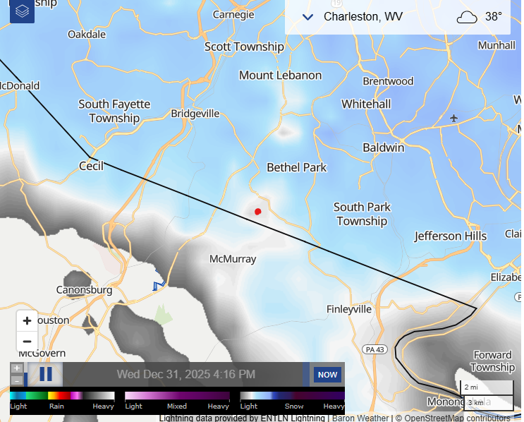
-
The vast majority of roofs there are built very steeply for that reason. My uncle and aunt lived in the Buffalo area and we loved to visit them. I grew up north of Albany where we ‘only’ got 70” a year or so.
-
NE IL caught in subsidence as primary band is southwest of model guidance. Actually have light drizzle mixed with some sleet here
-
You can't cliff jump if nobody is there.
-
January 2026 regional war/obs/disco thread
qg_omega replied to Baroclinic Zone's topic in New England
Doesn’t even matter with sensible weather, least week the euro had nothing and today the euro has nothing -
Do you think the blocking advertised won't verify? Just curious. Always tough in the south for various reasons
-
South East is still a funeral parlor TN Valley is sticking the course on mid month improvement for the eastern US Surprisingly no cliff jumping in Philadelphia
-
Pittsburgh/Western PA WINTER ‘25/‘26
colonel717 replied to Burghblizz's topic in Upstate New York/Pennsylvania
Radar looks great. Hope we all can reach at least 4 inches. -
I grew up in Upstate NY. It never got boring for my snow lover friends or for me and my family.
-

Pittsburgh/Western PA WINTER ‘25/‘26
ChalkHillSnowNut replied to Burghblizz's topic in Upstate New York/Pennsylvania
Nothing in the mountains yet -
Snow squalls too
-
Does NW Ohio live in a radar gap or does the system truly depend that much on lake enhancement that the returns weaken that dramatically in our area? Seeking the expertise of an actual met. I mean, it's still snowing, but has nowhere near the returns it had 10 miles before entering NW Ohio.. Thanks!!
-
Yeah the roof issues often would be the result of a heavy lake snowstorm followed by a rain event. The lake snow is typically so fluffy it doesn’t weigh a ton but rain followed by a flash freeze would cause issues
-

Central PA Winter 25/26 Discussion and Obs
Ruin replied to MAG5035's topic in Upstate New York/Pennsylvania
im so so so so tired of models showing cold the forecast shows cold then models flip and then the forecast goes from upper 20s to low 30s now shows mid 40s? this is from the 6th on. Now they are forecasting a mini warm up just form this signal just yesterday it was showing cold I looked out a week ahead cause half my job is outside. It just amazes me so now we are kicking the can down the road again for any chance of snow -

Pittsburgh/Western PA WINTER ‘25/‘26
MikeB_01 replied to Burghblizz's topic in Upstate New York/Pennsylvania
Light snow in bethel park . -
Not the best night for a light snowfall. Hopefully people drive safely
-

Pittsburgh/Western PA WINTER ‘25/‘26
SteelCity87 replied to Burghblizz's topic in Upstate New York/Pennsylvania
Still noticing some mixing driving through Kennedy. -
I am not convinced of the correlation between phase 6 and cold. What I think is occurring is QBO induced HL blocking(in some cases) is simply prevent the MJO signal from having influence over NA. I think the MJO has a much bigger impact when HL blocking is absent. As Cosgrove noted, the best thing we can do is simply look at the vortices lined-up which are approaching the US. You can kind of see the stormier patterns and deduce timing of such. Use analogs to fish out a good 500 pattern in addition to wx models. That is more accurate than relying on simply teleconnections which I am always guilty of...
-

Pittsburgh/Western PA WINTER ‘25/‘26
TheClimateChanger replied to Burghblizz's topic in Upstate New York/Pennsylvania
Snowing here, although it is a grainier snow, not the fluff from earlier. -

New Years Day 2026 - 1st snows of the new year possible
SJonesWX replied to Baroclinic Zone's topic in New England
what, you couldn’t find a .gif with humping wolves?


