All Activity
- Past hour
-

2026-2027 Super El Nino
bluewave replied to Stormchaserchuck1's topic in Weather Forecasting and Discussion
Yeah, the other overlapping marine heatwaves are adding warmer La Niña influences to the mix. This is why the pattern has been so much warmer in the East this spring into June than we have typically have seen during past developing super El Niños. But the next 10 days appears more Nino-like with a trough centering near the Great Lakes and more modest temperatures. -
Some of the models are starting to favor I-90. This is a SWFE type system but in June and we all know how those normally turn out.
-

2026-2027 Super El Nino
snowman19 replied to Stormchaserchuck1's topic in Weather Forecasting and Discussion
The Bjerknes feedback started last month. And those typhoons are only going to amplify the WWBs/westerlies behind them, in their wake. We are witnessing a historic event that will be remembered for many, many years to come -
which conventions are there next week in the area ?
-
Looks good to me. It’s looking colder than what models had for 23-24 Nino
-
Next town to the north (Carrabassett Valley) reported 3.04", and the eponymous river rose 7 feet at the North Anson gauge. Had 1.27" in our Stratus, 3.51" for June.
-
0.00 in Easton, at this point drought impacts are going to persist even if we start to get normal precip. It will take quite a bit of precip to recharge the shallow aquifer. Looks like streams are at all time lows and the groundwater is ~2' lower than all time lows. Some of the ag fields we monitor have not had a "normal" water table in 3 years.
-
Looks like a timing issue with my forecast for today, and the N front on Father's Day will be hanging back in the N Plains. Overall did OK. Watchin that LP for Father's Day tho. Could be another decent hit for the S sub.
-

2026-2027 Super El Nino
LakePaste25 replied to Stormchaserchuck1's topic in Weather Forecasting and Discussion
-
I HATE the high wind/no lightning events…it’s like that low top convection crap in the Fall
-
Chilly morning across the Northland with temps running from the low 30's to mid 40's (top 5 chill for some) with upper 40's along the shore. Rain moving in for the aftrn, which will be nice, with highs around 65-70.
-
Par for the course during convention season. We really need this one to work out. That northward trend is not our friend .
-
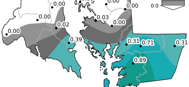
Glad for far southern Calvert, St Marys and the eastern shore - they needed something bad. None for me though (unless I count the 0.02 LOL)
-
June 19 2014: Heavy rain leads to widespread flooding in the Twin Cities metro area. Minnehaha Creek has its record crest of 17.64 feet on this date. Eden Prairie records 5.47 inches of rain, while MSP airport receives 4.13 inches, the highest daily total in 5 years. 1955: Hailstones the size of hen's eggs fall in Roseau County. For Friday, June 19, 2026 1835 - A tornado tore through the center of New Brunswick NJ killing five persons and scattering debris as far as Manhattan Island. The tornado provided the first opportunity for scientists to study firsthand the track of such a storm. (David Ludlum) 1938 - A cloudburst near Custer Creek, MT, (near Miles City) caused a train wreck killing forty-eight persons. An estimated four to seven inches of rain deluged the head of the creek that evening, and water flowing through the creek weakened the bridge. As a result, a locomotive and seven passenger cars plunged into the swollen creek. One car, a tourist sleeper, was completely submerged. (David Ludlum) 1972 - Hurricane Agnes moved onshore near Cape San Blas FL with wind gusts to 80 mph, and exited Maine on the 26th. There were 117 deaths, mainly due to flooding from North Carolina to New York State, and total damage was estimated at more than three billion dollars. Up to 19 inches of rain deluged western Schuylkill County PA. The rains of Hurricane Agnes resulted in one of the greatest natural disasters in U.S. history. Agnes caused more damage than all other tropical cyclones in the previous six years combined (which included Celia and Camille). (David Ludlum) (The Weather Channel) 1987 - It was a warm June day, with plenty of thunderstorms east of the Rockies. Lightning knocked out power at Throckmorton, TX, and ignited an oil tank battery. A woman in Knox City TX was struck by lightning while in her car, and a man was struck by lightning near his home in Manatee County FL. Strong thunderstorm winds overturned several outhouses near Bixby OK, but no injuries were reported. (The National Weather Summary) (Storm Data) 1988 - Temperatures soared above 100 degrees in the central U.S. for Father's Day. Fifteen cities reported record high temperatures for the date. Severe thunderstorms in Minnesota and Wisconsin produced softball size hail near River Falls WI, and wind gusts to 80 mph at Menomonie WI. (The National Weather Summary) (Storm Data) 1989 - Fourteen cities reported record high temperatures for the date as searing heat spread from the southwestern deserts into the High Plains Region. Record highs included 98 degrees at Billings, MT, 107 degrees at Valentine, NE, and 112 degrees at Tucson, AZ. (The National Weather Summary) 1990 - What would eventually be known as the "Inland Hurricane" stuck south central Kansas. This storm system produced a swath of 65 to 120 mph winds across six counties and caused $80 million dollars in damage. The peak recorded wind gust was 116 mph, which reaches low-end category 3 on the Saffir-Simpson hurricane wind intensity scale. On the enhanced Fujita Scale the 116mph winds would be rated an EF2. The storm knocked out power to all the Wichita TV stations, and they were off the air for hours. All but one of the Wichita Radio Stations, including the Wichita NOAA Weather Radio Station KEC-59, was knocked off the air. (National Weather Service Wichita) 2006 - Up to 11 inches of rain fell in the Houston, Texas area, causing widespread flash flooding. The Houston Fire Department rescued more than 500 people from flood waters, but no serious injuries or fatalities were reported. Observances: 19 Fri Juneteenth 19 Fri National Garfield the Cat Day 19 Fri National Martini Day 19 Fri World Sauntering Day 19 Fri Take A Road Trip Day 19 Fri Find a Leak Day 19 Fri International Box Day 19 Fri International Day for the Elimination of Sexual Violence in Conflict 19 Fri National FreeBSD Day 19 Fri National Watch Day 19 Fri World Sickle Cell Day
-
heh…found the old WBAN manual of observations from 1955. https://library.oarcloud.noaa.gov/noaa_documents.lib/Digitization_Scans/FY22 Scans/Manual_of_Surface_Observations_(WBAN).pdf
-
Great grandpa Wood measuring snow in the parking lot of Burlesque Blue in the 1950s.
-
NE CT attracts the biggest weenies
- Today
-
Was there last September. Been to a lot of places, but Alaska def cracked the top 3. Add the Banff to Jasper corridor and New Zealand to your bucket list in terms of ridiculously beautiful locations.
-
Per Mesonet the VWC is 0.02 at the Ridgely station. Probably about the same in my yard.
-
(002).thumb.png.6e3d9d46bca5fe41aab7a74871dd8af8.png)
Central PA Summer 2026 Discussion/Obs Thread
ChescoWx replied to Voyager's topic in Upstate New York/Pennsylvania
Below normal temperatures for most of the next week with beneficial rains arriving for much of the area by late Sunday into Monday. Sun should return this afternoon with lower humidity. The weekend looks great with highs in the upper 70's to near 80 degrees and lows in the 50's. The rain Monday could be significant with most models painting as much as 1" to 1.5" of needed rain.
-
E PA/NJ/DE Summer 2026 Obs/Discussion
ChescoWx replied to PhiEaglesfan712's topic in Philadelphia Region
Below normal temperatures for most of the next week with beneficial rains arriving for much of the area by late Sunday into Monday. Sun should return this afternoon with lower humidity. The weekend looks great with highs in the upper 70's to near 80 degrees and lows in the 50's. The rain Monday could be significant with most models painting as much as 1" to 1.5" of needed rain.
-
We miss to the NW one day, and to the SE the next. At least the lower shore and SE DE will get a tiny bit of relief from the drought.
-
Not sure you can do 6hrs successfully with wind like that anyway. But I assume most of those obs were COOP. People measured like weenies back then too. What’s that 27” in NE CT? Sticks out like a sore thumb.
-
It’ll all fall on the 4th I’m sure
-
I would be shocked if July was above average rain


