All Activity
- Past hour
-

Mid-Long Range Discussion 2026
WinstonSalemArlington replied to BooneWX's topic in Southeastern States
-
-
It’s getting pretty tiresome, put me on reaper watch. I’m a few fizzled threats away from talking about cherry blossoms.
-

January 2026 regional war/obs/disco thread
40/70 Benchmark replied to Baroclinic Zone's topic in New England
49 for the high here. All patches wiped...just bankings. -

Pittsburgh/Western PA WINTER ‘25/‘26
colonel717 replied to Burghblizz's topic in Upstate New York/Pennsylvania
Models were pretty good in showing first flakes around 8 which turned out right. -
Pittsburgh/Western PA WINTER ‘25/‘26
colonel717 replied to Burghblizz's topic in Upstate New York/Pennsylvania
Ray Petelin just said 1-2 for most through tomorrow but there could be persistent bands that give localized much more. -
18z is in and Panic Room hasn’t been bumped in 9 hours. Looks like we’re officially back in business?
-
I probably won't roll back in here until 12z. I might catch the 0z GFS run....if I am feeling remarkably good. Haha.
-
I still think it is a very long shot. However, where we are seeing some of these systems rain instead of snow...tells me that modeling is over doing the cold and there is room for this to come north. However, these Gulf snows verify more often than I care to enjoy.
-
To me, everything seems to be honing in on central and eastern parts of the Carolina’s
-

Storm potential January 18th-19th
SnoSki14 replied to WeatherGeek2025's topic in New York City Metro
I think we'll get something in this period but the better stuff waits til late Jan into Feb. Upcoming pattern is likely the most favorable pattern for snow and significant snows that we've had in years. And peak snow climo too. -

January 2026 regional war/obs/disco thread
jbenedet replied to Baroclinic Zone's topic in New England
Regarding northeast — it’s the first time all season we are below last year’s snow coverage and by a lot. -

First Legit Storm Potential of the Season Upon Us
WinterWolf replied to 40/70 Benchmark's topic in New England
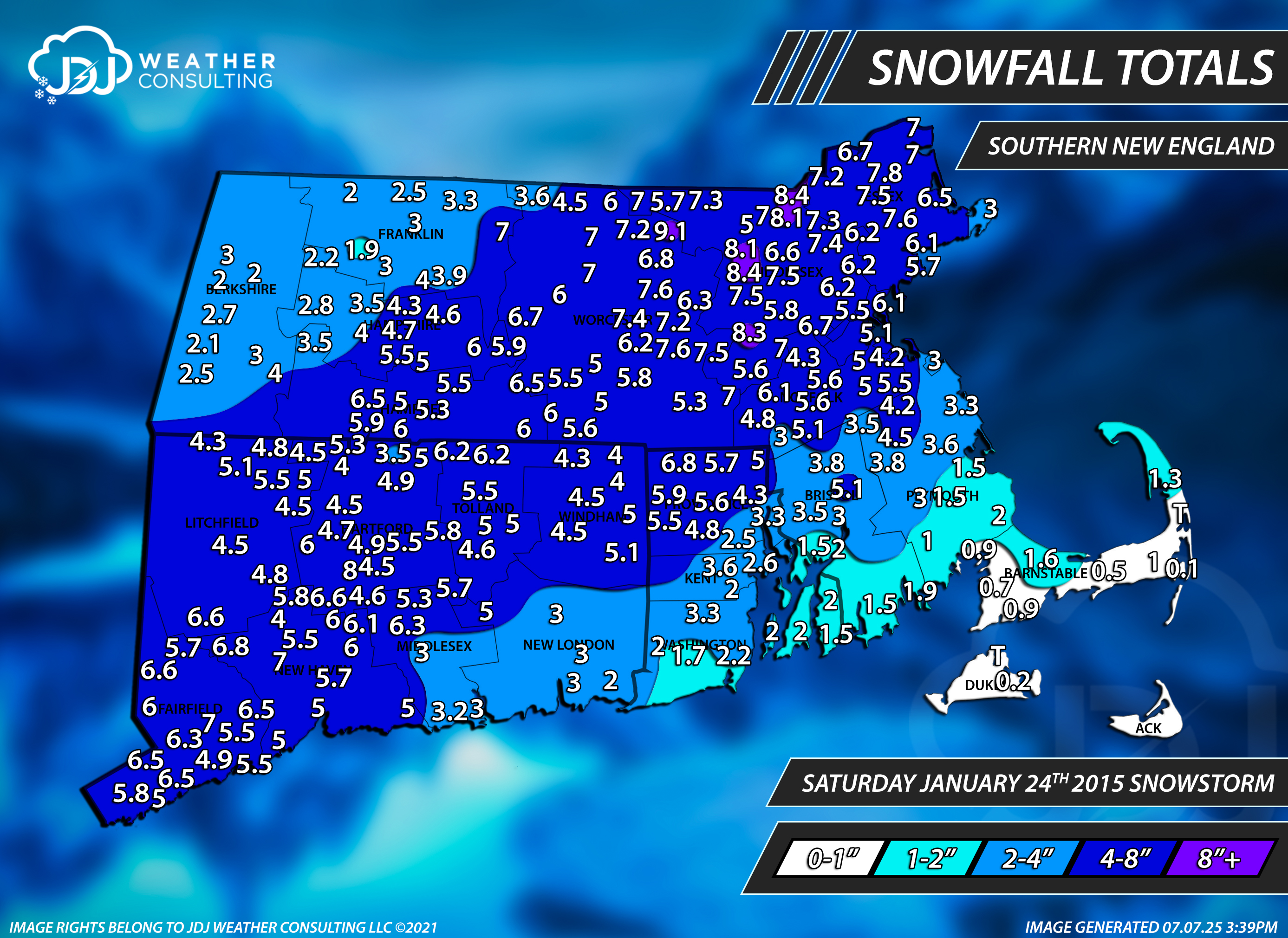
I see very very few 8’s on that map in CT. More 6” amounts not so much 8”. Again, wasn’t trying to downgrade anything pal, but it wasn’t that great here at my place…barely approached 4”. I was actually gonna say 2-4”, but being I barely made it to 4”, I went a little lower. Point is it was the appetizer for the most part. And yes, that blizzard was a dud for us, as was the whole big blitz was muted for us WOR. Still very good, but nothing historic out our way here. Anyway, let’s hope we are about to enter into something decent at the very least. -
Man a lot of beers and buffalo wings to digest. My day was cray. The cliff notes earlier—So very much appreciated. Thank you for that. I’ll eventually catch up on the rest of today by the time the Oz suite kicks in. Come on white gold!! You know we love watching you fall. Now get your ass on the ground and make a sledding hill for the kids or something.
-
0Z will be worth staying up for imo. .
-

First Legit Storm Potential of the Season Upon Us
weathafella replied to 40/70 Benchmark's topic in New England
I had to go to an event that Saturday night and there was one guy who reads but doesn’t post on the board. I remember going up to him as the 0Z guidance was rolling in saying “we’re getting buried!” barely containing myself…lol. -
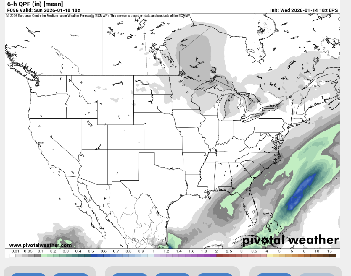
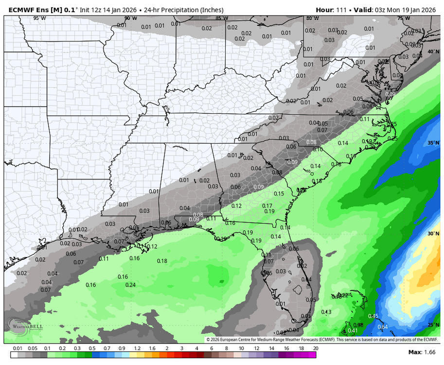
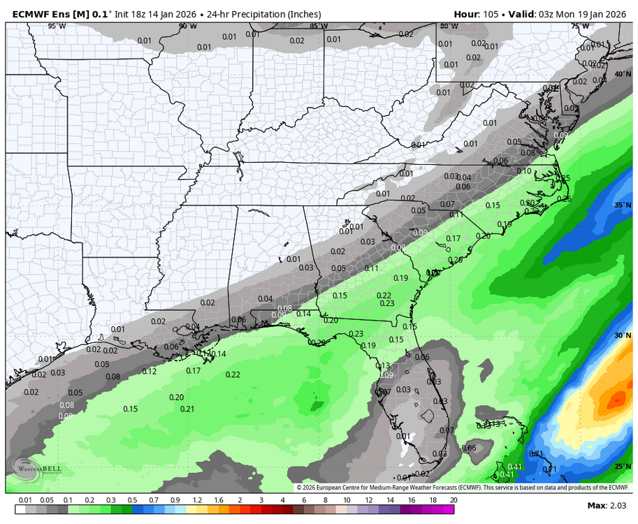
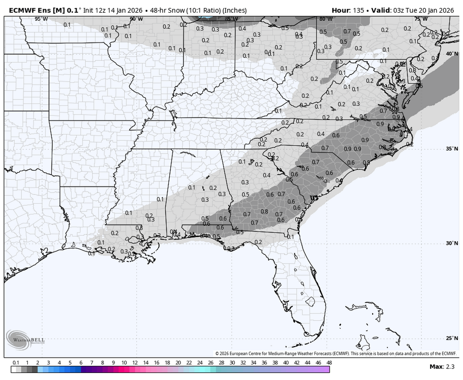
QPF 12z followed by 18z. And snowfall mean 12z followed by 18z

-
January 2026 regional war/obs/disco thread
jbenedet replied to Baroclinic Zone's topic in New England
Snow is gone here. Only the piles. And the piles outside of the parking lots will be gone tomorrow. -
Seems improved to me but I’ve looked at so many on the last 24 hours, not sure. Too lazy to pull the 12z
-

Winter 2025-26 Short Range Discussion
sbnwx85 replied to SchaumburgStormer's topic in Lakes/Ohio Valley
South side. Good spot rn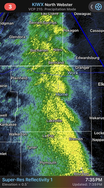
-
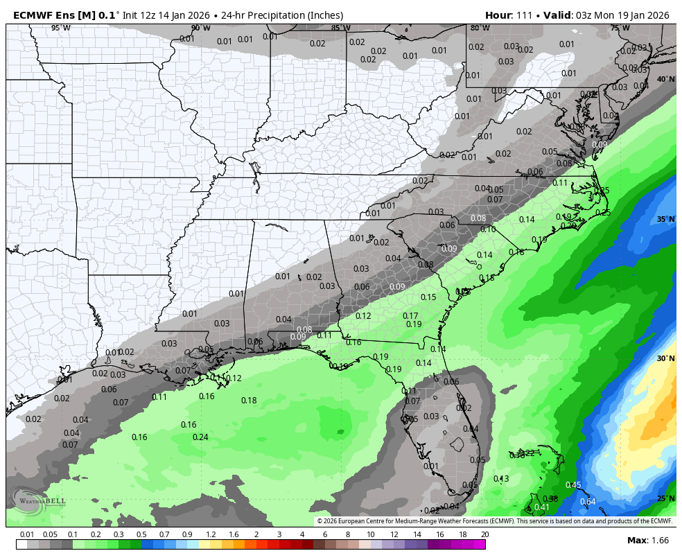
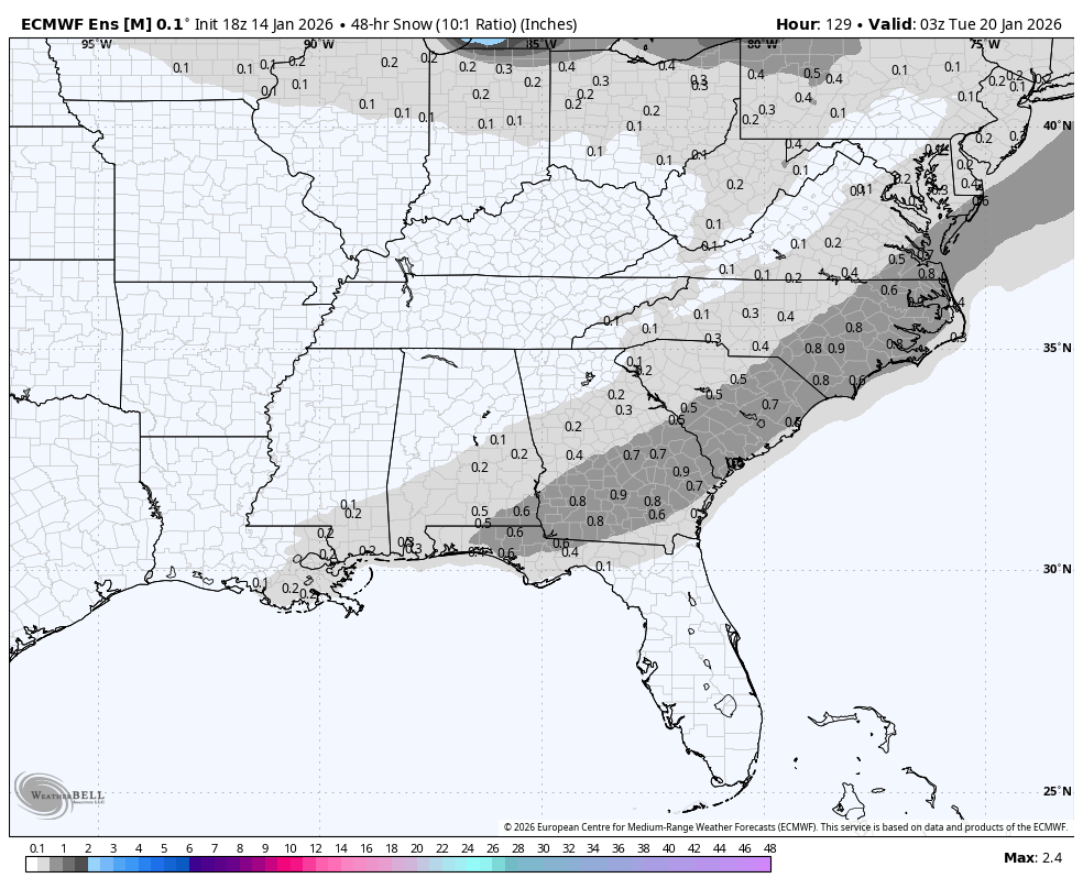
FWIW....DT from Wxrisk posted this WXRISK VIEW: There is the potential for a wave of LOW pressure to develop on the front but the question is how close to the coast. Most of the models for the past few days have been keeping this weak LOW well off the coast but the Trend started early WED with the GFS and the European AI models. DISCUSSION/ MAPS Last week in the newsletter I mentioned three specific winter storm threats between the period from January 15–30. AS i stated on SUNDAY the first threat of January 15- 16 is gone. A stronger arctic cold front will sweep through the Midwest and reach the East Coast on Saturday January 17. This cold front appears to be much stronger and looks like it will bring snow showers to much of the Middle Atlantic region even into the Piedmont as far east is I — — 95 from NYC to Richmond. It would not surprise me to see an 1–2 inches of snow in the Shenandoah Valley., the mountains of PA, western MD, WV, southwest VA, and the mountains west in NC.
-

January 2026 regional war/obs/disco thread
radarman replied to Baroclinic Zone's topic in New England
It did the coup de grace on the ice in my driveway so I was grateful for that. Only about 25% snow coverage left but looks to be back by Saturday night. -

Winter 2025-26 Short Range Discussion
OHweather replied to SchaumburgStormer's topic in Lakes/Ohio Valley
The models hinted at this on Sunday and then completely backed off, and never caught back up until the snow was almost over. Maddening as an operational met, splendid as a snow lover. My best explanation is that models were not properly initializing with the vort max that dove in from the Arctic, as everything associated with that (starting with the overperforming squalls in the Chicago area this morning) has over performed with this system. -

First Legit Storm Potential of the Season Upon Us
The 4 Seasons replied to 40/70 Benchmark's topic in New England
OK fair enough but calling it a 1-3 event when the whole state got 4-8 save New london middlsex Co is objectively wrong. The literal only report under 3 was Stonington. Picked up about 6 here. It was pure paste and a very solid base for the long duration snow pack
-

Winter 2025-26 Medium/Long Range Discussion
Chambana replied to michsnowfreak's topic in Lakes/Ohio Valley
Been a few years since we’ve had a GHD sub storm. What number are we on? IV or V?