All Activity
- Past hour
-

2026-2027 Record-breaking El Nino
40/70 Benchmark replied to Stormchaserchuck1's topic in Weather Forecasting and Discussion
100%. The NE forum have had countless get togethers. -
 Viagra generic over the counter: MenCare Virtual - sildenafil 50 mg price
 -
2026-2027 Record-breaking El Nino
40/70 Benchmark replied to Stormchaserchuck1's topic in Weather Forecasting and Discussion
100%. I have seen zero personal attacks from you....snowman launched attacks like that routinely, for as much as valuable info that he added. -

2026 C and E Pacific tropical activity
WxWatcher007 replied to GaWx's topic in Tropical Headquarters
Unfortunately, it looks like there won't be much if any more recon of Lala as recon is flying back to the mainland. The storm has struggled to organize a tight inner core, which makes it very hard for any kind of meaningful intensification to happen, but it's trying. We knew that would be an uphill battle. This morning's IR loop shows an attempt to wrap convection around the center, which is necessary for a faster pace of organization and intensification. Whether it truly gets there however, remains to be seen. Shear in the immediate vicinity doesn't look too bad at the moment. Lala remains embedded in a very dry environment, and although today it looks like it has more effectively fended off dry air intrusions, any ingestion of that dry air could disrupt an effort to organize and intensify. Marginal SSTs don't help either. All that said, the forecast looks on track. This is a higher end tropical storm, and with time and a somewhat conducive environment for organization and intensification a hurricane is certainly plausible. We're well within radar range now and can now watch for lower level organizational trends. Compared to this morning where there was a well defined but broad and ragged center, now we have what looks like a tightening inner core trying to form. Still, we don't have deep convection wrapping fully, but it's trying. Notice the wobble south too. As a chaser, once you get to this stage every wobble matters (even though you care about the long term movement still). It's still not a guarantee that we see an official landfall here, though impacts will be significant regardless. -
2026-2027 Record-breaking El Nino
40/70 Benchmark replied to Stormchaserchuck1's topic in Weather Forecasting and Discussion
I have zero qualms with the folks that have zero sense of humor exiting stage right. -
Overexposure, super rich, generic pop music, politics. Take your pick. Always gonna be haters. I am not a fan, but mostly because I don't like anything about her music.
-

Spring/Summer 2026 Pattern Discussion Thread
John1122 replied to Carvers Gap's topic in Tennessee Valley
My DP is 79 right now and I'm not happy at all about it. I saw that there were some 80+ dps around the area. -
SPC has issued day 1 marginal risk for 5% damaging wind https://www.spc.noaa.gov/products/outlook/day1otlk.html also a day 3 marginal risk out for southeastern tn 5% probabilities https://www.spc.noaa.gov/products/outlook/day3otlk.html .
-

Augdewst 2026: Summer's Last Stand
forkyfork replied to Prismshine Productions's topic in New England
winter is fleeting and it's getting shorter -

Augdewst 2026: Summer's Last Stand
Damage In Tolland replied to Prismshine Productions's topic in New England
There were a few members of ACATT that kept posting blue maps and BN and summer was broken and over etc. -
2026 Atlantic Hurricane Season
WxWatcher007 replied to Stormchaserchuck1's topic in Tropical Headquarters
Looks like that activity was a mirage. A lot of waves, but extremely hostile conditions. We'll need to see if any of those seedlings can survive into the western Atlantic I guess, but even there conditions don't look great. Might need to wait for better climo to arrive before any breakthrough is possible. -

2026-2027 Record-breaking El Nino
LakePaste25 replied to Stormchaserchuck1's topic in Weather Forecasting and Discussion
The main difference with 77-78 and modern El Niño events, is that the 77-78 warmth was confined to the upper midwest. Departures in NYC, DC, and Boston were not that impressive. In fact, NYC in Jan 1878 had a mean temperature below 30 degrees. Modern El Niño events, the upper midwest ridge is not only displaced eastward, but it’s likely more expansive, so places like NYC see major positive departures such as what occurred in December 2015.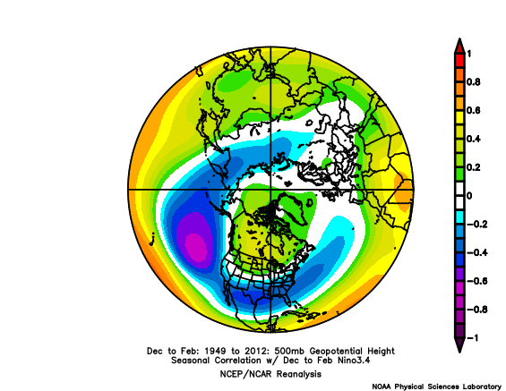
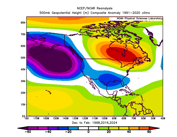
-

2026-2027 Record-breaking El Nino
BlizzardWx replied to Stormchaserchuck1's topic in Weather Forecasting and Discussion
I added these animations to my website if you want to make them. You can see the cold water building up to the west now with with the crazy warmth to the east. Edit: Just noticed South America is missing ha but I will fix it ARMOR3D_equatorial_subsurface_anom_2026-08-08_loop (1).mp4 -
Ok so I’ve become a Taylor Swift fan because of my daughter. Until recently I just never listened. I’m not much of a country fan so her early stuff wasn’t really my thing and never gave it a chance again until recently when I had to listen because my daughter is a swiftie. But I was shocked. I can listen to folklore and evermore all day no skips. All that to say I don’t understand something. The crazy amount of criticism I see and hear whenever she comes up. I am not saying people have to like her music. But when I thought I didn’t I never had a thing to say. If I did it was just “oh she seems like a nice girl just not my type of music”. Another example is I don’t like Drake. I tried. Just not my type of music. But I have never made a single post or comment about it. I don’t waste my time telling people he sucks. I just don’t listen. And I can admit from his sales and chart success that he is an amazing artist regardless of my personal preferences. So what is it about Taylor that creates this lightning rod where everyone who doesn’t like her music feels the need to make these nasty comments? She seems like a nice person. It’s odd to me.
-
Cicadas are finally here!
-
Hey what's with the clouds?! It's ruining my perfect Summautumn day.
-

2026-2027 Record-breaking El Nino
bluewave replied to Stormchaserchuck1's topic in Weather Forecasting and Discussion
This is a stronger event than the 1877-1878 reanalysis. It has significantly more oceanic heat to work with. That event produced what is probably the highest consecutive three month DJF departures for a single CONUS long term weather station. So not a stretch to say this is the strongest El Niño event in a long time. MSP Dec 1877…..+14.5° Jan 1878…..+10.2° Feb 1878…..+15.8° https://journals.ametsoc.org/view/journals/clim/33/11/jcli-d-19-0650.1.xml The strong 1877/78 El Niño in ERSSTv5 is consistent with independent SOI index derived from sea level pressure measurements in Darwin and Tahiti (Trenberth 1984). This El Niño event in ERSSTv5 is also consistent with the precipitation and temperature proxy data derived from tree rings and coral reefs and from the great famine record in southeastern Asia and Africa (Kiladis and Diaz 1986; Allan et al. 1991; D’Arrigo et al. 2008; Garden 2008; Hao et al. 2010; Räsänen et al. 2016; Singh et al. 2018; Lough et al. 2018). For example, Singh et al. (2018) used the Palmer drought severity index (PDSI) in Asia and demonstrated a record-breaking El Niño during 1877/78. D’Arrigo et al. (2008) used the PDSI in Australia and Lough et al. (2018) used the degree heating month index (DHMI) derived from coral reef in the tropical oceans; both showed a strong El Niño event during 1877/78. The strong 1877/78 El Niño in ERSSTv5 is consistent with that in HadSST1 (Fig. 2c; dotted blue) (Rayner et al. 2003). The Niño-3 index is approximately 0.5°C lower in HadISST1 than in ERSSTv5 from January 1877 to February 1878, which is in the range of the uncertainty of ERSSTv5 as indicated in Fig. 5d and Table 1. The temporal correlation between ERSSTv5 and HadISST1 Niño-3 indices between January 1877 and January 1879 is high (approximately 0.94). The consistency between the 1997/98 El Niño events in ERSSTv5 and HadSST1 is very good with strong correlations (0.99) between January 1997 and January 1999 (Fig. 2f). In conclusion, the strength (2.8°–3.5°C) and uncertainty (0.5°C) of the 1877/78 El Niño event are quantified by evaluating the selection of certain parameters in the ERSSTv5 ensemble. The strength of the 1877/78 El Niño appears approximately equal to those during 1982/83, 1997/98, and 2015/16. -
I said it’s possible. It is. But all we have to go on is history. And that suggests the issue is likely to be temps. I don’t buy the models showing these long cold periods. They do that every Nino. The climate models seem to think every Nino is 2010. Dunno why. But they’ve been off several in a row. So I am not buying that. IMO the issue is it’s likely to be too warm to snow the majority in the winter. But we’re also likely to have a juiced up STJ. So the question is do we get enough cold windows to time up 1 of those juiced up 2” qpf waves? So the math becomes is it too warm 95% of the time and then a 1998 becomes likely. Or is it only 75% and then 1983 or 2016 is more likely. Somewhere in there it becomes more likely we do get lucky with at least one wave. And maybe we even get lucky with 2 but that falls in the same boom category just more boom. The bust is it’s too warm 90% of the time and we don’t time anything up and have very little snow. I am not arguing a twist can’t happen just that those are the most likely two scenarios. IMO maybe 40% boom, 40% bust, 20% some weird unforeseen outcome based on new climo. Just my 2 cents. I don’t have a crystal ball.
-
super el nino banter thread
LakePaste25 replied to forkyfork's topic in Weather Forecasting and Discussion
if i play the lottery more often, i have a higher chance of winning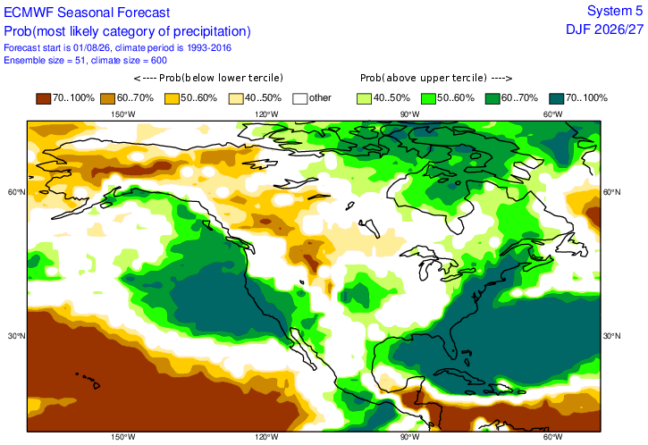
- Today
-
Forky is always fear mongering. I remember him and others were saying how we will not get a hecs for a long time or even 40 plus inch winters. Well look at last winter.
-
Its not only about the El Nino. Of course it will be warmer than last winter . I guess no one learned about long range forecasting after the long range forecasting busts in the past few years.
-

E PA/NJ/DE Summer 2026 Obs/Discussion
Birds~69 replied to PhiEaglesfan712's topic in Philadelphia Region
76F/DP 60F Sunset is now under 8pm and losing more and more daylight each day...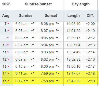
-

2026-2027 Record-breaking El Nino
MJO812 replied to Stormchaserchuck1's topic in Weather Forecasting and Discussion
Historic event = historic storms -
Warmth isn't evenly distributed. Several LR models have the US as the coldest anomaly on earth while the rest of the planet torches. It all depends on where the ridges set up. Despite that you can never go wrong with saying it'll be an AN winter temperature wise in today's AGW era.
-
(002).thumb.png.6e3d9d46bca5fe41aab7a74871dd8af8.png)
Central PA Summer 2026 Discussion/Obs Thread
ChescoWx replied to Voyager's topic in Upstate New York/Pennsylvania
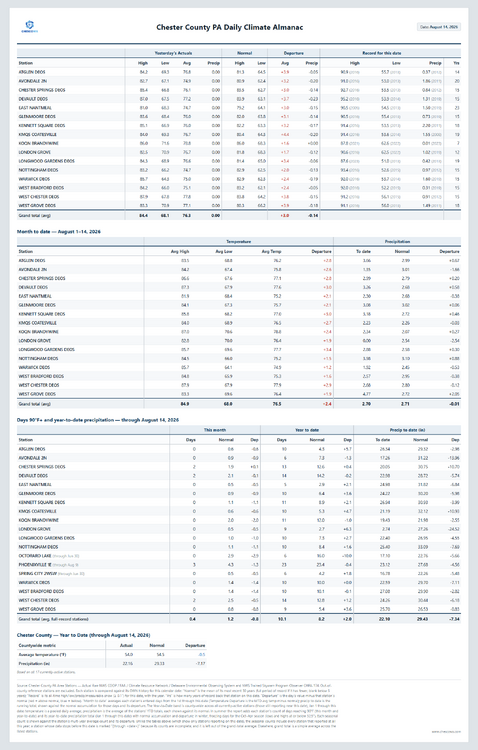
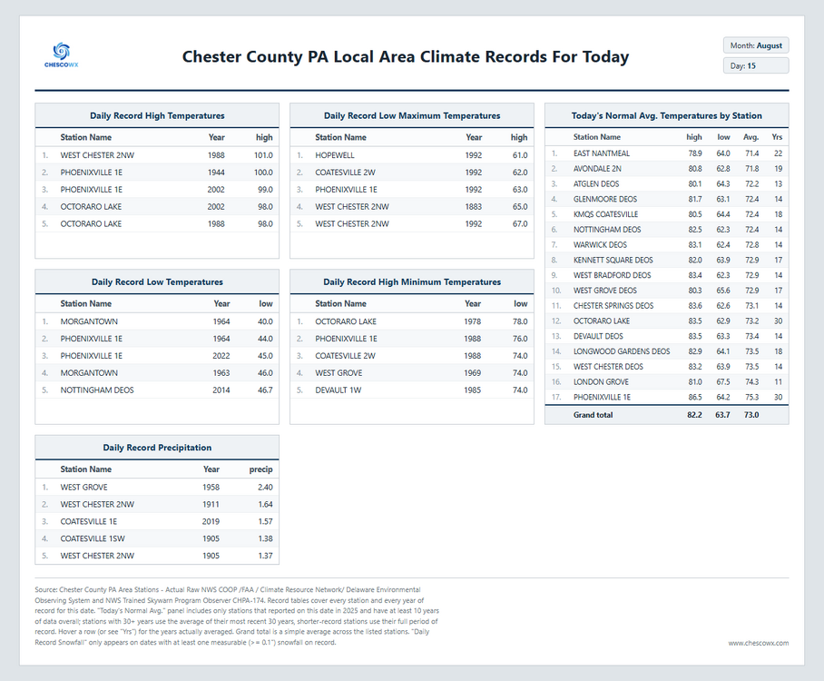
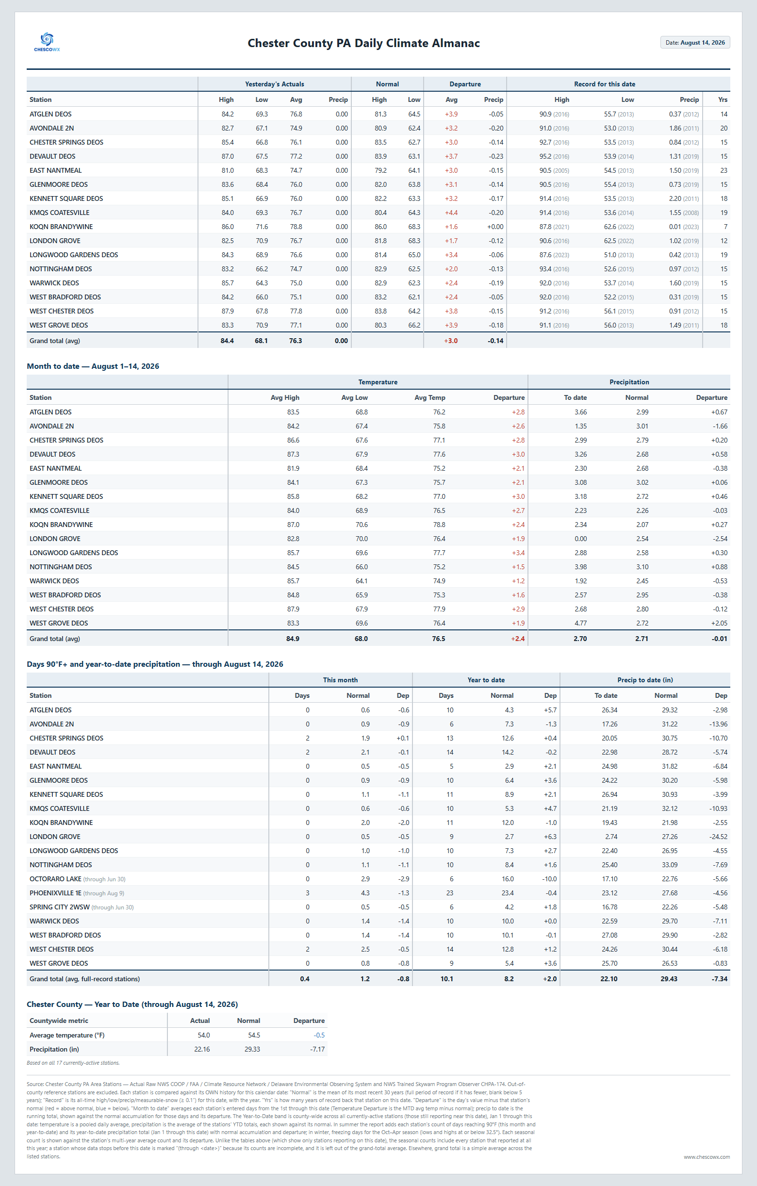
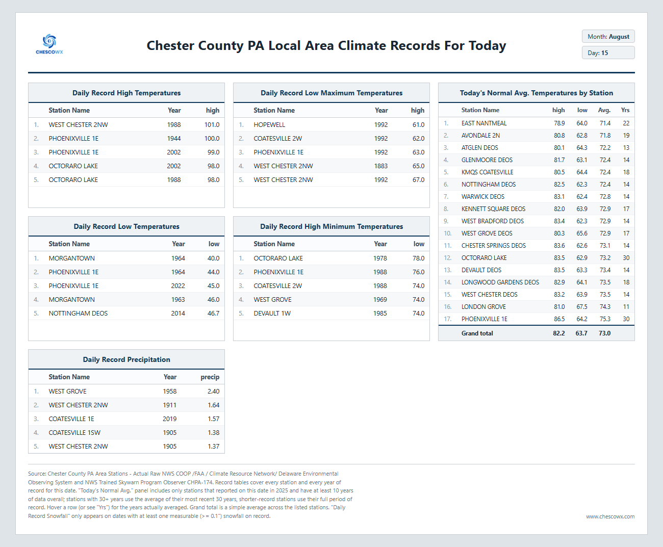
Great weather today with comfortable humidity and temperatures not too far from normal for mid-August. We turn wetter and a little stormy by later tomorrow into tomorrow night some spots could see upwards of an inch or so of rain. We turn sunny any by Monday with pleasant weather returning and lasting through mid-week.