All Activity
- Past hour
-
Agree. There were some runs with more of a meso low in the Gulf of Maine, but thats trended northward and slower to develop
-

January 2026 regional war/obs/disco thread
CoastalWx replied to Baroclinic Zone's topic in New England
I had a good season 21-22 but it’s been pretty bad here. Ever since then it’s been the epicenter of porkage. Hopefully we all have a good rest of the winter. -
-
I see ~no chance for Dec ‘25 to come in warmer than Dec ‘39’s 37.7. Through the 27th (last widespread US warm day), MTD could rise to ~38.2. But 12/28-31 are progged to avg ~31. That would bring the full Dec back down to ~37.2.
-

January 2026 regional war/obs/disco thread
Damage In Tolland replied to Baroclinic Zone's topic in New England
Starting NYD -
Micro analyzing op runs in the LR(or even worse, whining about MBY details) is futile and annoying. Folks gonna do what they do though.
-
January 2026 regional war/obs/disco thread
CoastalWx replied to Baroclinic Zone's topic in New England
Well euro has some chances -

January 2026 regional war/obs/disco thread
binbisso replied to Baroclinic Zone's topic in New England
I believe you would sign for this. Appreciate all your hard work
-
The 12z Euro...I don't even know what it is doing after 300. In my mind, I am kind of just tossing crazy looks. Hopefully, I am not tossing something that is going to actually happen. But the overall trend at 12z on both deterministic and ensembles is to slide the NAO towards the Davis Straits, build some type of ridging in the NAO/PNA region, Alaska stays cold(good thing I think this time around), and an evolving storm track along the East Coast. I would be really surprised not to see some sort of Arctic outbreak during January. The good thing is there is a bit more juice (precip) to squeeze since about 0z overnight. As @John1122noted, we definitely have to beware of Canada getting scoured. We have seen that during recent winters. I freely admit that could happen. I do kind of think we may see a chunk of that cold get dislodged southward and get trapped under a block until the cold just spins and burns out. I could easily be wrong. If that happens, Canada would stay cold enough.
-
Yeah, that looks ideal for STJ and Gulf Action on up through Hattras as you said. Man, providing there's enough cold and it looks to be, and the STJ is active enough that would be great. Edit: The only concern might be is STJ systems taking a bit too low road, especially if weak.
-
Perfect BLUF.
-
Still snowing
-
12z Euro active with multiple chances. I like it.
-
December 2025 regional war/obs/disco thread
Damage In Tolland replied to Torch Tiger's topic in New England
We had a very localized icestorm here two winters ago where literally the two hilltops in town near or over 1k had under .50 accretion but the next morning big winds hit with 50-60mph gusts and all hell broke loose. The rest of the town had zero ice. Every house in the neighborhood lost at least one tree or had large limbs down, of course I was in heaven but that’s how I’m programmed . Big winds on thickly iced trees is wild . https://imgur.com/a/zQzYoDx#7PlJaSM https://imgur.com/a/zQzYoDx#mbAc3Hu https://imgur.com/a/zQzYoDx#WFHuic1 https://imgur.com/a/zQzYoDx#oVK4yun https://imgur.com/a/zQzYoDx#OTESvFN -

December 2025 regional war/obs/disco thread
ma blizzard replied to Torch Tiger's topic in New England
not enough QPF for ice storm warnings and we aren’t advecting in colder temps / lower dews so its more of an in situ icing with a slow climb to 32 sure it will be icy in NNE but think it will fall short of being that destructive -
we are so back
-
Yeah, been thinking about how close that is to happening and it causing me anguish to see how a couple little Flies keep hampering it from evolving on Modeling, lol
-
lol us analyzing a 348 hour map. We definitely are in the shut the blinds window right now
-
Kind of a yin and yang look. But if I showed you this....not a bad look. When I toggled to a 5 day 500 pattern, this is what I got. Kind of like putting it in the blender and washing out the craziness. That will work, and it is cold. That storm signal is almost perfect with the low inside Hatteras.
-

Wounded Duck Strikes Back: Dec 26 & 27th Winter Storm Obs
weathafella replied to WxWatcher007's topic in New England
The one thing that was a bit surprising was the fact that once radar echoes reached me it started snowing at a good rate. I thought I’d be fighting dry air but that seemed to be displaced 20-30 miles further north. -
We do wind well in the mid-Atlantic Extreme Western Allegany-Western Garrett-Eastern Garrett-Western Grant-Western Mineral-Western Pendleton- 1144 AM EST Sat Dec 27 2025 ...HIGH WIND WATCH IN EFFECT FROM MONDAY MORNING THROUGH TUESDAY AFTERNOON... * WHAT...West winds 25 to 35 mph with gusts up to 55 to 65 mph possible, with the highest gusts near the ridgetops. * WHERE...In Maryland, Eastern Garrett, Extreme Western Allegany, and Western Garrett Counties. In West Virginia, Western Grant, Western Mineral, and Western Pendleton Counties. * WHEN...From Monday morning through Tuesday afternoon. * IMPACTS...Damaging winds could blow down trees and power lines. Widespread power outages are possible. Travel could be difficult, especially for high profile vehicles.
-
Look what's in the Great Lakes.
.thumb.png.c0587caab00bcde851f37ffab60ac7ab.png)
-
Only so many winters left for us right...ain't nobody got time to wait
-
Close but no cigar
.thumb.png.8f322d3510610816865e2af0048b95c6.png)
-
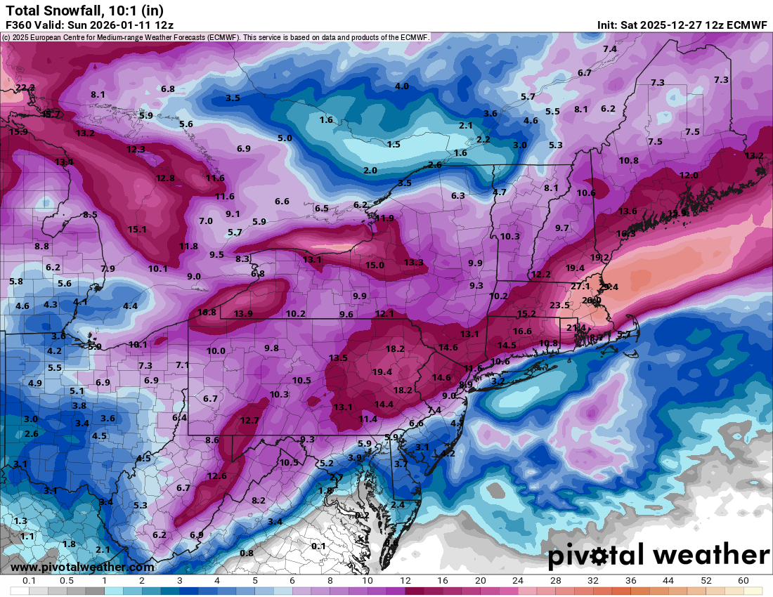
Banana High, peak climo, cold Canada and the outcome still sucks. Yes its at OP at 348 hours, LOL.


.png.e85d64652ff90fec3cf7106f1c3b7229.png)


.png.f6679933be4182beba63351a7e198398.png)
