All Activity
- Past hour
-

Central PA Summer 2026 Discussion/Obs Thread
pawatch replied to Voyager's topic in Upstate New York/Pennsylvania
57 degrees for the low this morning. -
The Hamden F4 is my earliest memory. We’re due!
-
Closest Cocorahs station to my location showing on 2.15” of rain since May 1st. Arid.
-
Lol 71/61 here.
-
Think that was the best I’ve ever seen any usmnt play
-
62.0/56 Refreshing morning.
-

Central PA Summer 2026 Discussion/Obs Thread
mahantango#1 replied to Voyager's topic in Upstate New York/Pennsylvania
US National Weather Service State College PA Favorites · · 530 AM Saturday June 13th, 2026: Enjoy today with lots of sun and lower humidity than in recent days. There is potential for more strong to severe storms on Sunday, mainly during the afternoon into the evening. The main threat will be strong winds and heavy downpours. - Today
-
Central PA Summer 2026 Discussion/Obs Thread
mahantango#1 replied to Voyager's topic in Upstate New York/Pennsylvania
-
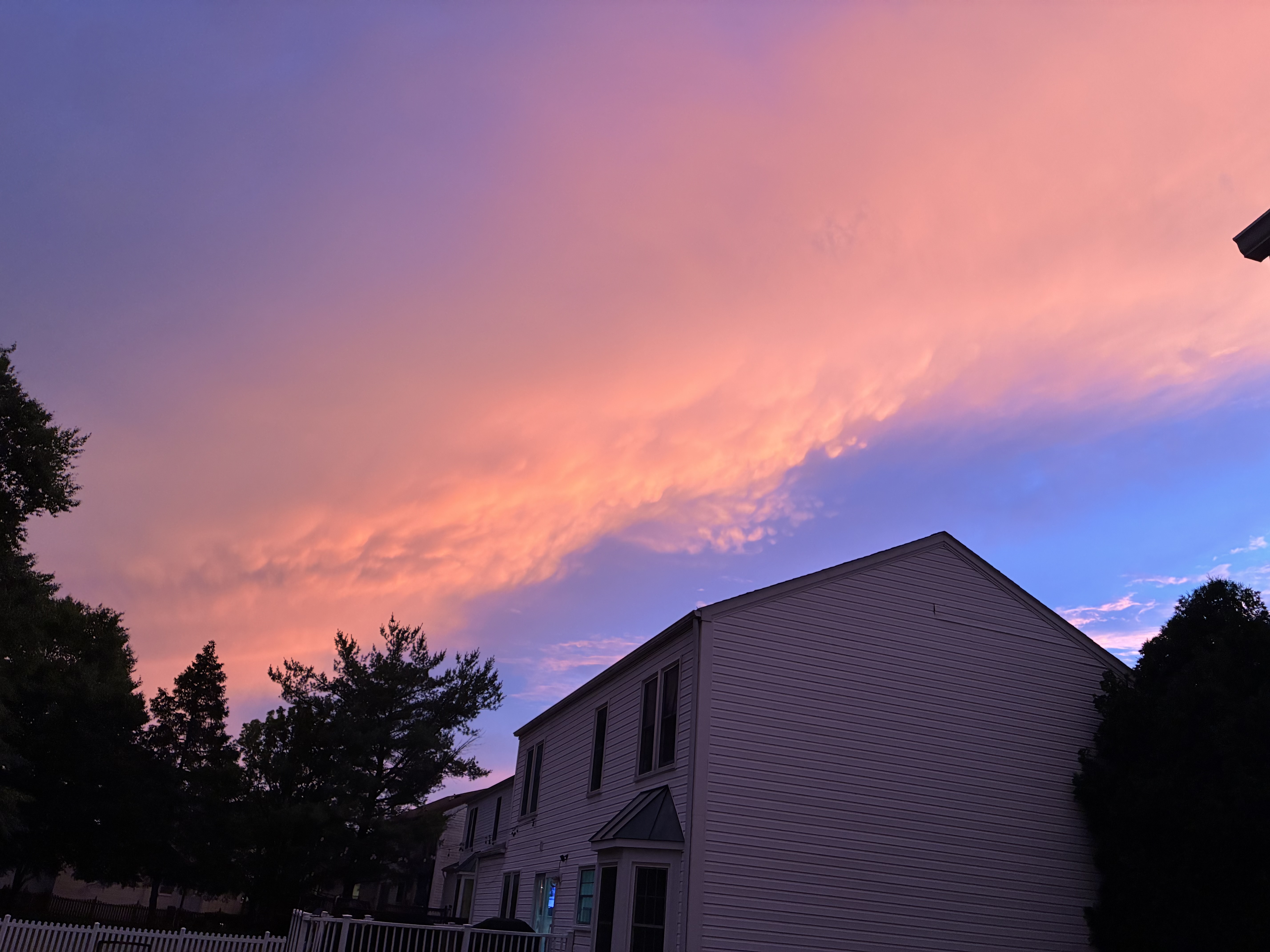
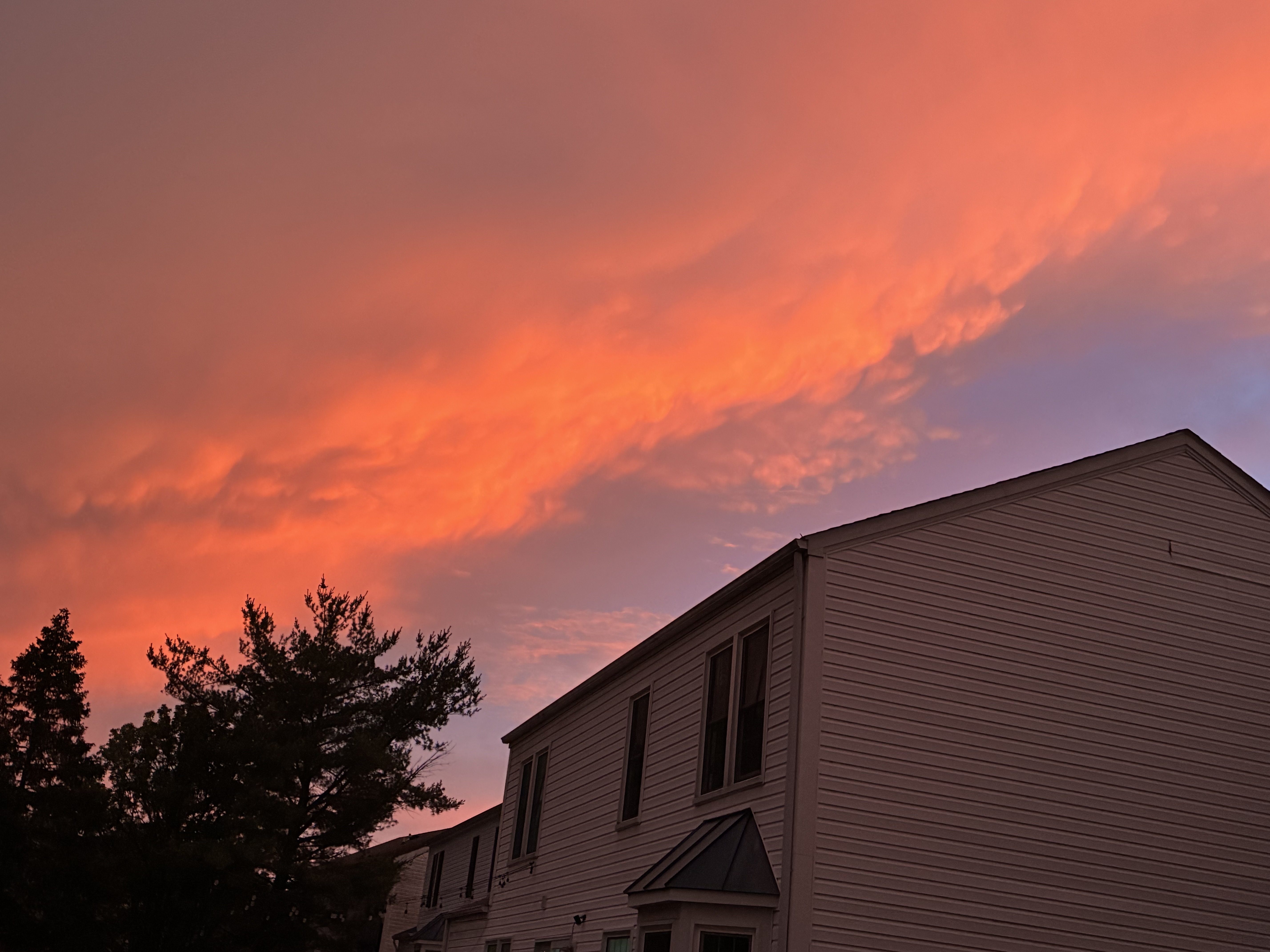
One more from Friday sunset

-
Photos from sunset Friday in Columbia


-
Central PA Summer 2026 Discussion/Obs Thread
mahantango#1 replied to Voyager's topic in Upstate New York/Pennsylvania
.CLIMATE... The high temperature on Friday at Harrisburg reached 94 degrees. This broke the old record of 92 degrees, last set in 2017. -
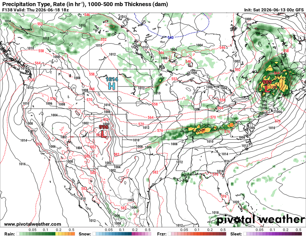
SPC DY6 has SVR outlooked OH Valley-DCA-NYC? Time for WxWiz to starting getting ready. He been waiting for something like this for so long! And CoastalWx can stop saying "SNE SUCKS for convection!" LOL. From pattern recognition, I am very impressed, and it takes a *lot* to impress me for svr these days. An unusually strong sfc low for mid June is fcst (below 990 mb) to track across southern Ontario and Quebec. 00z GFS and ECMWF same idea on 6/18 for wind fields -- GFS a bit stronger than the ECMWF, but does not matter, they are still through the roof for this time of year. GFS 120 kt 250, 95 kt 500, 75 kt 700, 65 kt 850 and 925 in New England this time of year w/ available CAPE this time of year? Ho-ly ( )!!! Actually, w/ these kind of wind fields, you don't need more than say 2000-2500 CAPE for sigtor. Anywhere from the OH Valley-Mid Atlantic-Northeast may be in for a sig tor event! I don't have to quote the big tor outbreak for our region, but just mention July 10, 1989, and WxWiz will faint! FYI, winds of 65 kt at 850 existed for the ORH 1953 event. For the July 10. 1989 event, the sfc low that tracked across NNE was "only" 998 mb. Not overstating things here for potential at all. But of course, it's all in the details. *But* again, SPC outlooking SVR this part of the country on DY6 this time of year? That says something! You don't get that w/o a synoptically-evident set up.
-
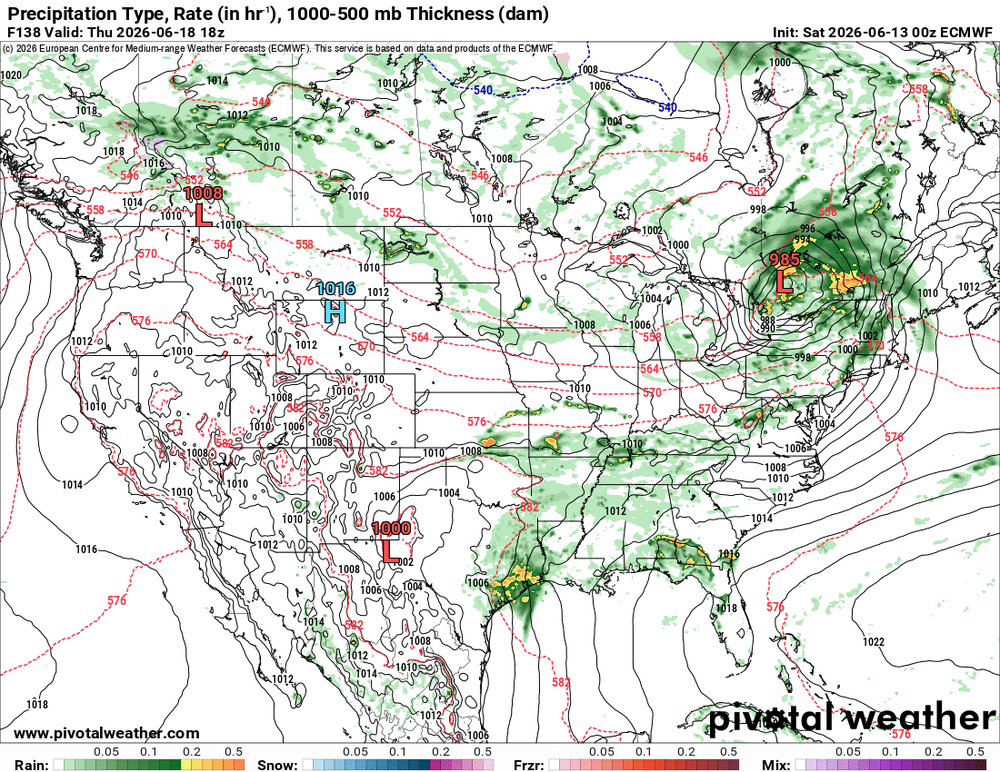
The DY6 SPC outlook? It is definitely warranted. An unusually strong sfc low for mid June is fcst (below 990 mb) to track across southern Ontario and Quebec. Wind fields are clearly high end for this time of year. GFS and ECMWF same idea on 6/18 -- 70 kt 500, 60 kt 700, 50 kt 850, 40 kt 925 over Mid-Atlantic. That means business and this time of year w/ higher CAPE? Anywhere from the OH Valley-Mid Atlantic-Northeast may be in for a sig tor event June 23, 1944 comes to mind so does June 8-9. 1953. Also July 10, 1989 (New England's largest single day tornado outbreak for number of tornadoes). Could be a derecho event. Not overstating things here for potential at all. But of course, it's all in the details. *But* SPC outlooking SVR this part of the country on DY6 this time of year? That says something! You don't get that w/o a synoptically-evident set up!


- 650 replies
-
- 3
-

-
- severe
- thunderstorms
- (and 7 more)
-
This ^.
-
I'll be on atlantic city tuesday through Friday.. maybe ill get lucky..
-
This has the feeling of being one of our "runs" of severe risk. Been a while. When this happens it can last a week or two anecdotally
- 650 replies
-
- 2
-
-

-
- severe
- thunderstorms
- (and 7 more)
-
Morning AFD from LWX for Sunday DISCUSSION... KEY MESSAGE 1...Dry conditions today, severe thunderstorms return Sunday. Quiescent wx returns today with mostly sunny skies and lower humidity. Temps will still be 5-8 degrees above average for highs (upper 80s to around 90), but it will feel cooler and less humid as dewpoints drop into upper 50s and low 60s. Sun features the next chance for severe wx. SPC has maintained a Level 2 out of 5 (Slight Risk) for the area, however they have increased the wind probs to 30%. Could see upgrade to Level 3 out of 5 (Enhanced Risk) depending on model trends over the next 24 hours. Stay tuned for the latest... In terms of the meteorology, a sw will rotate around the base of an UL trof Sun. Ahead of the wave, southerly flow will usher in anomalous moisture with PWs nearing 2" and dewpoints near 70F. The sw will bring height falls aloft near peak heating resulting in notable instability. The above will overlap with increasing wind shear. The combination of increasing instability, shear, and large scale forcing for ascent ahead of the shortwave and an approaching cold front will lead to the development of widespread thunderstorms during the afternoon, some of which could be severe. Model soundings indicate steep low level lapse rates (especially for the Mid-Atlantic) which will result in higher DCAPE values and therefore stronger wind gusts. There`s still a fair amount of spread in guidance with respect to the timing and exact placement of the storms, but as of now the threat looks to be greatest to the east of the Blue Ridge. Some guidance has discrete supercells ahead of the front, followed by linear segments which make sense given unidirectional shear. The main threats with storms will damaging winds, large hail, locally heavy rainfall, and frequent lightning. WPC has a Level 1 out of 5 (Marginal ERO) for the metros, but progressive nature and prevailing drought look to limit the overall flood threat. The system`s cold front will move through Sunday night, advecting cooler and drier air into the region, which will bring the threat for severe thunderstorms to an end.
- 650 replies
-
- 1
-
-
- severe
- thunderstorms
- (and 7 more)
-
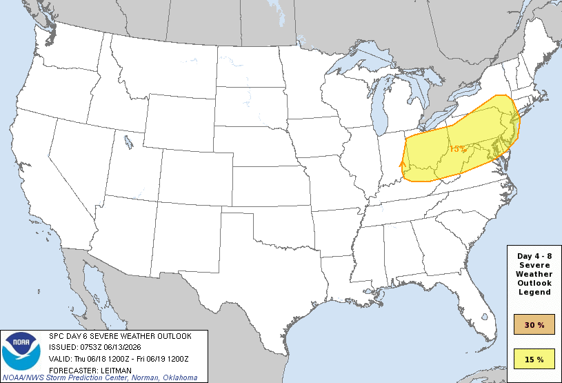
Oh okay then SPC... @high risk @Kmlwx @wxmeddler @Eskimo Joe Day 4-8 Convective Outlook NWS Storm Prediction Center Norman OK 0253 AM CDT Sat Jun 13 2026 Valid 161200Z - 211200Z ...DISCUSSION... ...Days 5-6/Wed-Thu -- Lower MO/Mid-MS Valley to Ohio Valley and Mid-Atlantic... An upper trough is forecast to deepen over the Upper Midwest/Great Lakes on Wednesday. As this occurs, an intensifying 500 mb jet streak will develop across the central Plains and increase to 80-100 kt as it moves into the Mid-MS Valley Wednesday night, and spreads eastward across the Ohio Valley and Northeast on Thursday. At the surface, low pressure will develop over the northern/central Plains late Tuesday night into early Wednesday. As this occurs, increasing southerly low-level flow will quickly transport rich Gulf moisture northward into the Lower MO/Mid-MS Valley by Wednesday afternoon as the surface low moves across IA and a trailing cold front moves eastward in tandem with the low across portions of the central Plains and Mid-MS Valley. Strong to extreme instability is forecast across the strongly sheared warm sector. An all-hazards severe thunderstorm event appears likely. An intense southwesterly low-level jet is expected to develop during the evening. This could support upscale growth into an MCS moving across portions of the Midwest Wednesday night, posing a risk for swaths of damaging winds. This system will spread east on Thursday across parts of the Ohio Valley into the Mid-Atlantic/Northeast. A continued risk for all severe hazards, and possible MCS with damaging winds, will persist as the mid/upper jet streak is forecast to remain quite strong as it overspreads a seasonally moist airmass. While some timing differences of aforementioned features is evident in various NWP guidance, overall medium range consensus and mean calibrated ML/AI guidance suggests a multi-day severe episode is likely as this system overspreads portions of the Midwest to the Mid-Atlantic/Northeast, though the 15 percent risk areas may shift in the coming days as details become better resolved, and higher probabilities are possible in subsequent outlooks. The southern extent of severe potential is more uncertain across parts of the Plains toward the TN Valley as these areas will remain further removed from stronger flow aloft. ..Leitman.. 06/13/2026
- 650 replies
-
- 2
-
-
- severe
- thunderstorms
- (and 7 more)
-
2/5/30 on morning day 2 SPC OTLk. 30 wind is from BR eastward to Eastern Shore Day 2 Convective Outlook NWS Storm Prediction Center Norman OK 1215 AM CDT Sat Jun 13 2026 Valid 141200Z - 151200Z ...THERE IS A SLIGHT RISK OF SEVERE THUNDERSTORMS ACROSS PORTIONS OF THE UPPER OHIO VALLEY TO THE MID-ATLANTIC REGION... ...SUMMARY... Scattered severe thunderstorms capable of damaging wind gusts are expected across the Mid-Atlantic vicinity Sunday afternoon and evening. Additional strong to severe storms are expected across the Upper Ohio Valley and Lower Great Lakes area. ...Mid-Atlantic Region... An upper trough will be oriented over the Upper Great Lakes Sunday morning. A shortwave embedded within the large-scale troughing will pivot east across the Midwest/Lower Great Lakes to the Mid-Atlantic. Ahead of this main shortwave trough, most guidance suggests a lead impulse will overspread the Chesapeake Bay vicinity during the afternoon. Low to midlevel west/southwesterly flow will increase to around 30-40 kt in association with these features. This enhanced flow will aid in organized thunderstorms in multiple bands during the afternoon and evening. Rich boundary layer moisture is expected to be in place to the lee of the Blue Ridge across the NC/VA Piedmont and Chesapeake Bay vicinity into southeast PA/southern NJ. Northward extent of moisture return remains a bit uncertain, but at least low 60s F dewpoints should filter into much of PA and NY ahead of an eastward-advancing cold front. Strong heating will support a corridor of moderate destabilization, with MLCAPE in the 1500-2500 J/kg range across eastern VA/NC and vicinity. Instability is expected to be more muted with northward extent where boundary layer moisture will be somewhat less and midlevel lapse rates rather poor. Scattered to numerous thunderstorms are expected to develop within lee troughing near the Blue Ridge and spread east across the Chesapeake/DelMarVa/southeast PA/southern NJ vicinity during the afternoon to early evening. Damaging wind gusts will be the main concern with these storms, though isolated hail or a tornado also will be possible. If current model trends continue, higher coverage probabilities/upgrade to Enhanced (Level 3 of 5) could be needed in subsequent outlooks. For now, wind probabilities have been increased to 30 percent across the DelMarVa into southeast PA/southern NJ. Additional bands/clusters of storms are likely to develop during the afternoon ahead of the advancing cold front from the Upper Ohio Valley into PA/NY. While instability will be lower across this area, deep-layer flow will be stronger. Linear bands and clusters will pose a risk for isolated severe/damaging wind gusts through the evening.
- 650 replies
-
- 2
-
-
- severe
- thunderstorms
- (and 7 more)
-
0.38 from storms today - first precip of the month....
-
It's sne..
-
For the next 2 weeks or so, storms passing north of us with warm fronts/cold fronts fairly fast moving with a cool pool of air aloft and big upper low over the Great Lakes. This pattern can produce outbreaks of severe weather for us if things time out right and we get into (however briefly) the warm sector. I think the pattern locks into a steamy summer pattern around June 28th give or take a day or two or three. Things will change as we know. WX/PT
-
The severe risk completely busted in NC today
-
Lost power about 1915 when the line went through. The wind/rain was blindingly heavy for just a few mins, but that was enough to cause havoc. Was a surreal event to see even for an old fart like me who has seen a lot. Power is still out atm ivo much of Vienna/Oakton. Crew hasn't even been dispatched yet on our specific outage, which is impacting 510 customers. Getting a crew dispatched is the first step to get beyond the "pending investigation" status. We'll be lucky if service is restored by sunrise. It was very odd how the power went out this time. Normally the transformers try to reset up to 3 times before kicking off for good (according to the VA Power lineman). In this case, the power went off/on several times and then flickered very bad for several minutes in unison with the typical "boom" from the transformers; before I shut off the service at the main breakers to protect electronics. We've never experienced that sort of service shutdown before. We're still on generator power to run the basics. Still trying to convince my wife it's time for a whole-house auto-start system. With the frequency in how often we lose power I'm about ready to invest in a proper system. We're on well and septic and the surge of 220VAC well pump is the main drain on our 9500 watt generator. Currently 35,000 customers out on Dominion's outage site.
- 650 replies
-
- 2
-
-
- severe
- thunderstorms
- (and 7 more)
-
And moist adiabatic lapse rates to 550 mb...EEECH!!


.thumb.gif.f92b16c631a1d15d405ed77b33f0710d.gif)


