All Activity
- Past hour
-

January 2026 regional war/obs/disco thread
JKEisMan replied to Baroclinic Zone's topic in New England
People, snow is on the way. Chill -

January 2026 regional war/obs/disco thread
WxWatcher007 replied to Baroclinic Zone's topic in New England
“Forgettable” event for Ray as he gets 13” and Sey-Mour gets 18”? -
Largely agree but individual ensemble members still say north is a risk.
-
(002).thumb.png.6e3d9d46bca5fe41aab7a74871dd8af8.png)
January 25-26 Winter Storm Potential
ChescoWx replied to Ralph Wiggum's topic in Philadelphia Region
-

January 2026 regional war/obs/disco thread
RUNNAWAYICEBERG replied to Baroclinic Zone's topic in New England
She coming again this weekend and most likely coming harder. She’ll even come for Ray if he’s in a good mood. -
This upcoming storm might be exactly what the south and central US needs. Winter never started in those parts, been very warm and dry. A storm like this, absent a huge shift to the north, would put Texas through the lower Mid Atlantic at average to above average snowfall. That's their ticker to a winter redemption, especially because lower and central Mid Atlantic is running very below average with snowfall. And it looks quite cold east of the Rockies for most of february as well.
-

January 2026 regional war/obs/disco thread
Damage In Tolland replied to Baroclinic Zone's topic in New England
Body punches exchanged ! -

Possible Record Breaking Cold + Snow 1/25 - 1/26
BoulderWX replied to TriPol's topic in New York City Metro
The thing im most excited about in terms of potential is the duration. I expect a lot of changes between now and Sunday, but if we could have it snow for even half of that time, I'd be happy - don't even care how much we get if we have snow falling for that long -
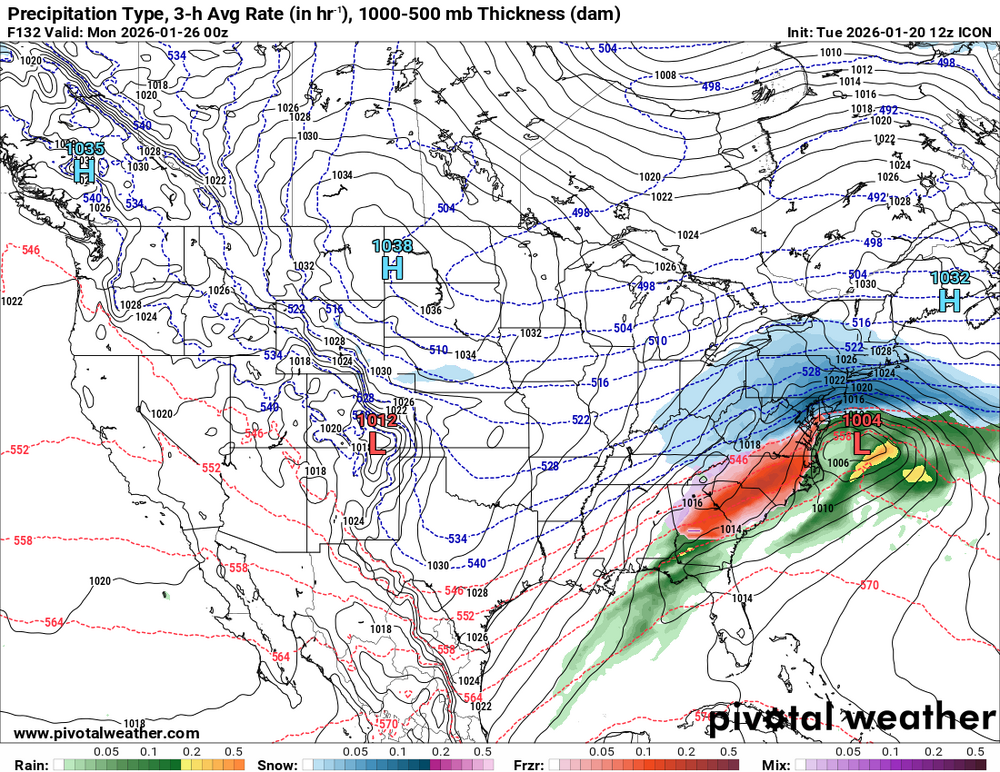
Wow, that 12Z GFS modeled historic snowstorm came out of nowhere! But of course that’s just great entertainment so far out.Well before that and thus much more significantly as of now, KCHS has since yesterday afternoon been warning about a significant ZR threat for this weekend even way down into much of the just inland and even possibly coastal SE SC/upper GA that could linger til as late as Mon AM. As I posted last night, the last few GEFS runs of individual members have been strongly advertising a ZR threat in the KCHS forecast region:KEY MESSAGE 2: WIDESPREAD PRECIPITATION IS EXPECTED TO OCCUR THIS WEEKEND, BRINGING INCREASING POTENTIAL FOR A WINTER WEATHER EVENT TO IMPACT THE REGION. MODELS CONTINUE TO SUPPORT POTENTIAL FOR A WINTER WEATHER EVENT IMPACTING AT LEAST PORTIONS OF SOUTHEAST SOUTH CAROLINA AND SOUTHEAST GEORGIA THIS WEEKEND. THE SYNOPTIC PATTERN WILL FEATURE STRONG, COLD HIGH PRESSURE WEDGING DOWN THE EASTERN SEABOARD THROUGH THE WEEKEND, WITH AN AREA OF LOW PRESSURE FAVORED TO DEVELOP OFF THE SOUTHEAST COAST. BROAD MID LEVEL TROUGHING WILL LARGELY BE IN PLACE TO START, WITH A STRONGER WAVE DIVING INTO THE REGION LATER IN THE WEEKEND. FURTHER ALOFT, WE CAN FIND AN IMPRESSIVE UPPER LEVEL JET POSSIBLY ON THE ORDER OF 160+ KNOTS. THE CONDITIONS WILL CERTAINLY BE IN PLACE TO SUPPORT PRECIPITATION SPREADING ACROSS THE AREA, WITH INCREASING CONFIDENCE OF SOME OVERLAP WITH COLDER TEMPERATURES. ATTENTION THEN TURNS TO PRECIPITATION TYPE AS COLD AIR SETTLES INTO THE REGION. WHILE FORECAST DETAILS ON TIMING, AMOUNTS, AND P-TYPES WILL CONTINUE TO BE REFINED IN THE COMING DAYS, A PERUSAL OF MODEL SOUNDINGS INDICATE A NOTABLE WARM NOSE CENTERED AROUND 850 MB WITH SURFACE TEMPS DROPPING TO NEAR OR BELOW FREEZING SATURDAY NIGHT INTO SUNDAY MORNING. THIS WOULD SUGGEST FREEZING RAIN AS A PRIMARY THREAT, WHICH ALSO JIVES WITH THE LATEST NBM PRECIP PROBABILITIES. THE PROBABILISTIC WINTER STORM SEVERITY INDEX (WSSI-P) SHOWS CHANCES OF MINOR WINTER STORM IMPACTS ACROSS THE ENTIRE AREA, WITH EVEN A 20- 40% CHANCE OF MODERATE IMPACTS ESPECIALLY NORTH OF I-16.THE COLUMN BEGINS TO DRY OUT LATER SUNDAY INTO MONDAY, BUT IF PRECIPITATION LINGERS, THE THREAT FOR WINTER WEATHER COULD CONTINUE INTO EARLY MONDAY AS ENSEMBLE GUIDANCE SHOWS HIGH LIKELIHOOD FOR SUB-FREEZING TEMPERATURES AGAIN SUNDAY NIGHT. WE WILL ALSO NEED TO BE ON THE LOOKOUT FOR TEMPS/WIND CHILLS APPROACHING COLD WEATHER ADVISORY CRITERIA SUNDAY NIGHT AND BEYOND.
-
Anyone have the link to model verification? I want to see how bad the gfs is on a chart. Their used to be an ncep link but the one I have says it’s temporarily unavailable.
-

Richmond Metro/Hampton Roads Area Discussion
Ephesians2 replied to RIC Airport's topic in Mid Atlantic
Compromise between GFS and UKMET/CMC would be ideal -
Lol wow it's amazing how different the GFS op run is from its own ensembles!!! Ridiculous!!
-

January 2026 regional war/obs/disco thread
40/70 Benchmark replied to Baroclinic Zone's topic in New England
Tough shit. Sey-Mour 40/70andlikeit -
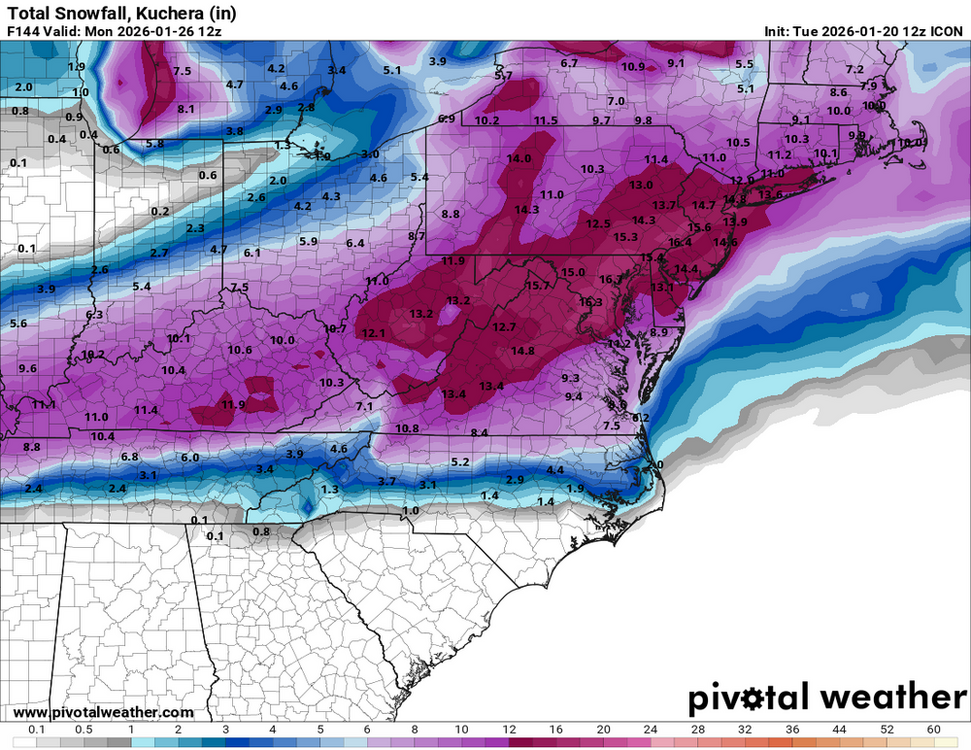
Congrats SAV on the op GFS. BUFKIT has 5.5" of snow. Annual record is 4.6, daily record 3.6.
-
30s/10s for the week after Jan 1996. Even colder after the Feb 2nd 1996 massive winter storm that this one reminds me of. After the blizzard it was very cold for March, but only for a day after it departed. By 3/16 it was back in the upper 40s.
-

January 2026 regional war/obs/disco thread
ORH_wxman replied to Baroclinic Zone's topic in New England
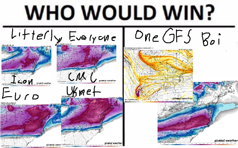
GFS seems on its own right now. -
Disagree as the ICON has the system NE more with ice.
-
The snow melted fairly quickly in sunny spots after 1993. After 1996, it was frigid. That's the only subzero temperature at KCHA in my lifetime. There were piles of sleet in the mall parking lot until March.
-
-
It's a de-amplified run. To see the ensemble mean push 6"- 10" regionwide as a "fail" is still a sign of a potentially healthy event.
-
January 2026 regional war/obs/disco thread
WxWatcher007 replied to Baroclinic Zone's topic in New England
This is what happens when Richmond gets feet of snow. If we can’t have it, nobody can. -
Euro, EuroAI, GGEM, Ukie, and Icon are all phasing in the northern shortwave with some or all of the Baja low. So you get this extended duration event with coastal redevelopment that enhances snow in the RIC-PHL corridor and then lets NYC-BOS join the party.
-

January 2026 regional war/obs/disco thread
Lucy Pull replied to Baroclinic Zone's topic in New England
Looks like they linger precip in the area a bit longer. Wonder if some individuals are similar to the CMC. -

January 2026 regional war/obs/disco thread
Sey-Mour Snow replied to Baroclinic Zone's topic in New England
Tried that but you post too much it still shows up -
Ending my brief crashout - unless the EURO comes in and scares me. GEFS is fine. Drier. No real south shift.


