All Activity
- Past hour
-
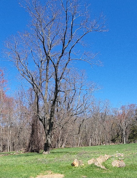
Sweet day today. Lucked into acres of black locust. The only wood I will travel for. Pretty little farm too...
.jpg.7d120cd04a2fba0391f5e7b7b76c6d9d.jpg)
-
Similar to 24 hours ago, the smoke here has returned. This should once again clear up this afternoon with the sea breeze.
-
It rained for ours back in the infamous summer of 2009. Had 50 people inside my house lol.
-
I have my son's baptism tomorrow
-
Thanks for opening a thread for this, some of the soundings for Monday look pretty wild. Obviously every severe weather threat has many failure modes, but the potential is definitely there for a high-end event.
-

2026 Spring/Summer Mountain Thread
Maggie Valley Steve replied to Buckethead's topic in Southeastern States
We've had a nice week with cool mornings and warm Spring days. It's looking that a pattern change is ahead with rain chances returning tomorrow continuing into next week. -

Potential Sever Weather Outbreak 4/27/2026
A-L-E-K replied to pen_artist's topic in Lakes/Ohio Valley
riding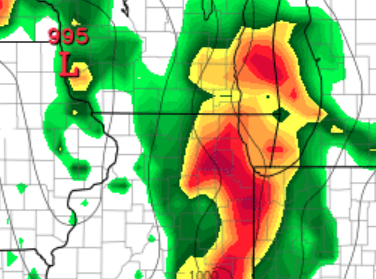
-
Agreed, the area's I needed to fix all grew in nicely.
- 837 replies
-
- 1
-

-
- april showers bring may..
- rain
- (and 2 more)
-
Nice dry Sunday, we'll take that.
-
Pop up thundershower - Alexandria/Mount Vernon
- Today
-

Potential Sever Weather Outbreak 4/27/2026
sbnwx85 replied to pen_artist's topic in Lakes/Ohio Valley
Thinking another QLCS tornado threat this far east is best case scenario. -
At long last, we finally have a NESIS rating. Category-4 and #5 all time (this is skewed since the methodology was changed around 2010)
-
Yeah it's not going to be doom and gloom 100% of the time. We'll have our mix of pleasant days and crap day, it's just the crap days may win out. So, we just take the pleasant days we can and hope they happen on the weekend. For the most part its just going to be a bit on the cool side, but with climatological maxes slowly creeping up, even the "cool days" with respect to climo won't be too bad.
-
Not a drop . Charlie Steiner
-
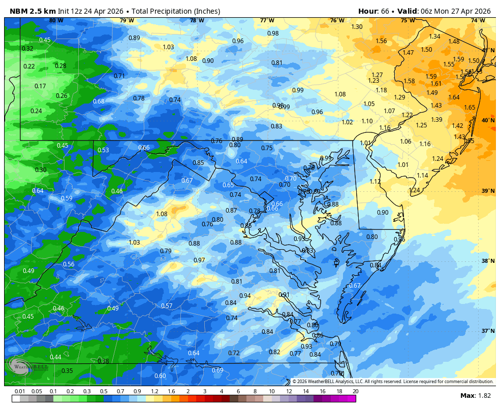
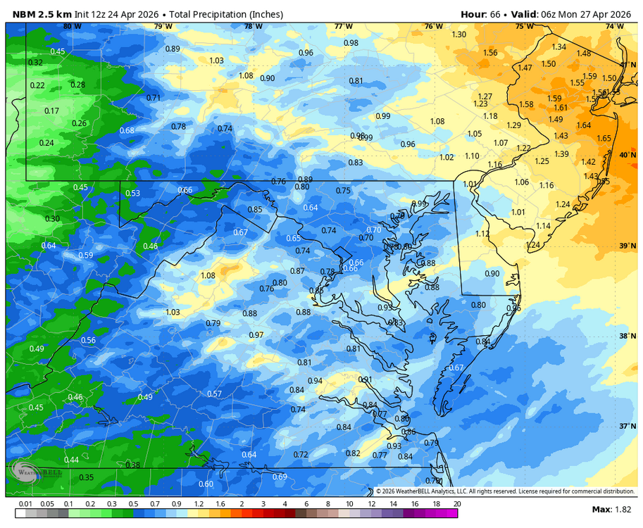
WB 12Z NBM
-
We can hope high pressure wins out over SE canada-it would be cool but at least we could get some sun.
-
NAMS are a soaker here too bad it's a weekend yet again
-
Unfortunately, this crap pattern is probably going to persist at least through the first few weeks of May. These types of patterns aren't ones that tend to break down quickly either.
-
Better that we can refresh the water table and have it be nasty vs just nasty drizzle that does nothing but ruin a day (or here often multiple days).
-
Unfortunately not looking so hot possibly through the first half of the month
-
April 24 1854: It feels like summertime at Ft. Snelling with temperatures in the 80s. ^Note: Record high is 84 in 1962. So would be a top 5 event at the least.^ For Friday, April 24, 2026 1899 - Two women and one son lived to tell the story of being picked up by a tornado and carried more than a fourth of a mile, flying far above the church steeples, before being gently set down again. The young boy and one of the ladies said they had the pleasure of flying alongside a horse. The horse "kicked and struggled" as it flew high above, and was set down unharmed about a mile away. (The Weather Channel) 1908 - Severe thunderstorms spawned eighteen tornadoes over across the Central Gulf Coast States claiming the lives of 310 persons. The state of Mississippi was hardest hit. A tornado near Hattiesburg MS killed 143 persons and caused more than half a million dollars damage. Four violent tornadoes accounted for 279 of the 310 deaths. The deadliest of the four tornadoes swelled to a width of 2.5 miles as it passed near Amite LA. The tornado also leveled most of Purvis MS. (David Ludlum) (The Weather Channel) 1987 - Showers and thunderstorms produced heavy rain in the Middle Atlantic Coast Region. Up to seven inches of rain drenched Virginia in three days. Morgantown WV received 4.27 inches in 24 hours, and flooding was reported in south central West Virginia. (The National Weather Summary) (Storm Data) 1988 - Low pressure produced high winds and severe thunderstorms in the Southern Plains Region. Strong thunderstorm winds destroyed two mobile homes at Whitt TX injuring two persons. Winds associated with the low pressure system gusted to 70 mph at Guadalupe Pass TX. (The National Weather Summary) (Storm Data) 1989 - Twenty cities in the central U.S. reported record high temperatures for the date. Russell KS was the hot spot in the nation with a reading of 101 degrees. Evening thunderstorms produced severe weather from Colorado to Wisconsin. Hail four and a half inches in diameter was reported at Sargeant NE. (The National Weather Summary) (Storm Data) 1990 - Thunderstorms produced severe weather from the Southern High Plains to north central Kansas. Thunderstorms spawned ten tornadoes, including one which injured four persons and caused 1.5 million dollars damage at Shattuck OK. Thunderstorms also produced softball size hail at Wheeler TX, wind gusts to 85 mph southwest of Arnett OK, and 13.45 inches of rain near Caldwell TX, which resulted in the worst flooding in recent memory for that area. (The National Weather Summary) (Storm Data) 2010 - An EF-4 tornado up to 1.75 miles wide travels 149.25 miles through Mississippi, the widest and fourth longest path in Mississippi history. It left behind major destruction to businesses, churches and homes, four fatalities in Yazoo City and ten fatalities across the state. From the notes at Ft Snelling: Rapid early April warm-up: 76 F at 1500 on 5 April. Warm late April: afternoon readings of 85 F and 86 F at 1500 on 19, 20 April, respectively. St. Paul newspaper [26 April] noted that "during the past ten days, the weather has resembled that of June...the thermometer ranging from 75 to 90 degrees in the shade...". Note: The 85 reading would have stood as the record until 1985 when the temp reached 87. On the 20th, the 86 reading would still be standing as the record as the current record is 83 in 1980. The 90 degree reading(s) would have been the earliest 90 reading for many decades. Currently that record is 91 in 2002 on 4/15 followed by 95 on 4/21/1980, 90 on 4/22/1980, and 91 on 4/25/1962. 91 on 4/30/1934 was the first official 90+ reading in the MSP record for April. More than likely April 1854 would be a record, or near record warm April as there were some warmer days in the 70's earlier in the month as well.
-
Always seems the highest totals get pushed NE. WPC not as bullish as Mount Holly. Mount Holly AFD states .50 to 1 inch.
-
Looks like Steinbrenner NE of HFD-GON or so
-
Possibly just dry air for you. I expect we'll get at least little bit of precip down here. Good for the weeds.


.thumb.gif.f92b16c631a1d15d405ed77b33f0710d.gif)