All Activity
- Past hour
-
Make that 6 inches in Charlottesville the first 6 days of August
-
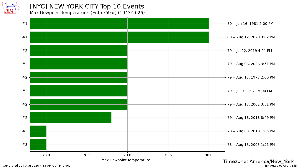
If 7/15/1995 isn't on this list, I refuse to believe it's true. That was a very anomolous event. That is by far the highest dew point/heat index in most of the surrounding area.
-
Congratulations!! I got a grand total of .02" for Thursday, August 6................. .30" total for the first 6 days of August. Where's the rain??? At Charlottesville. Over 4 inches for the first 6 days of August.
-
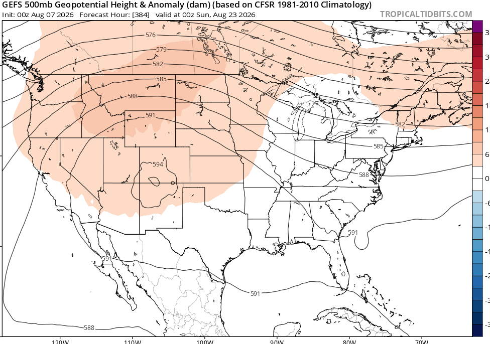
no real end in sight to this look
-
 Buy generic 100mg Viagra online Sildoliko - Cheap generic Viagra
 -
get ready to MAD mild and damp
-

Central PA Summer 2026 Discussion/Obs Thread
mahantango#1 replied to Voyager's topic in Upstate New York/Pennsylvania
-
Cialis 20mg price - [url=http://tadaliko.com/#]Tadaliko[/url] Tadaliko
-
So, pretty much like being out in my garden. It's icky, that's for sure.
-

Augdewst 2026: Summer's Last Stand
Damage In Tolland replied to Prismshine Productions's topic in New England
Stein decided to give us rain but webbed feet for storms. I knew this would happen here -
https://tadaliko.com/# cheapest cialis
-

2026 Mid-Atlantic Severe Storm General Discussion
dailylurker replied to Kmlwx's topic in Mid Atlantic
I feel like short range models have been especially terrible this season. Parameters look healthy like vortex is saying. Today looks great for some fun imo.- 1,723 replies
-
- 1
-

-
- severe
- thunderstorms
- (and 7 more)
-
Central PA Summer 2026 Discussion/Obs Thread
mahantango#1 replied to Voyager's topic in Upstate New York/Pennsylvania
Hazardous Weather Outlook National Weather Service State College PA 318 AM EDT Fri Aug 7 2026 PAZ004>006-010>012-017>019-024>028-033>037-041-042-045-046-049>053- 056>058-063-080800- Warren-McKean-Potter-Elk-Cameron-Northern Clinton-Clearfield- Northern Centre-Southern Centre-Cambria-Blair-Huntingdon-Mifflin- Juniata-Somerset-Bedford-Fulton-Franklin-Tioga-Northern Lycoming- Sullivan-Southern Clinton-Southern Lycoming-Union-Snyder-Montour- Northumberland-Columbia-Perry-Dauphin-Schuylkill-Cumberland- 318 AM EDT Fri Aug 7 2026 This Hazardous Weather Outlook is for central Pennsylvania. .DAY ONE...Today and tonight. Heavy rain is possible from scattered thunderstorms today which may lead to isolated instances of flash flooding. .DAYS TWO THROUGH SEVEN...Saturday through Thursday. Heavy rain is possible from scattered thunderstorms on Saturday again, which may lead to isolated instances of flash flooding. .SPOTTER INFORMATION STATEMENT... Spotters are encouraged to report significant hazardous weather. Hazardous Weather Outlook National Weather Service State College PA 318 AM EDT Fri Aug 7 2026 PAZ059-064>066-080800- Lebanon-Adams-York-Lancaster- 318 AM EDT Fri Aug 7 2026 This Hazardous Weather Outlook is for central Pennsylvania. .DAY ONE...Today and tonight. Strong to severe thunderstorms with gusty winds are possible this afternoon and early this evening. Heavy rain is also possible as well, which may lead to isolated instances of flash flooding. .DAYS TWO THROUGH SEVEN...Saturday through Thursday. Heavy rain is possible from scattered thunderstorms on Saturday again, which may lead to isolated instances of flash flooding. .SPOTTER INFORMATION STATEMENT... Spotters are encouraged to report significant hazardous weather -

Augdewst 2026: Summer's Last Stand
vortex95 replied to Prismshine Productions's topic in New England
- Today
-
Augdewst 2026: Summer's Last Stand
vortex95 replied to Prismshine Productions's topic in New England
At least could you see the FQT LTGIC DSNT NW last night from Weymouth? -
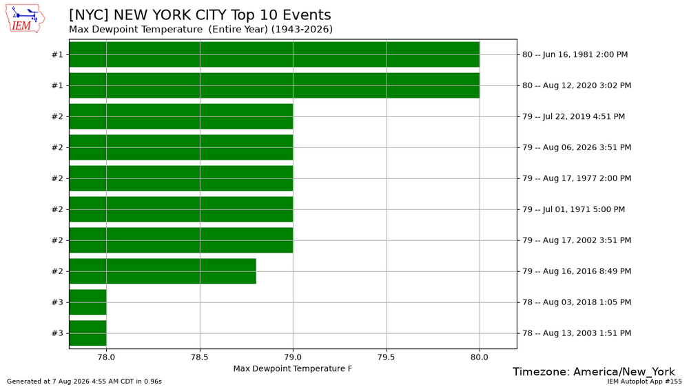
NYC just had their 2nd highest dew point of all-time at 79°. Probably some enhancement from being so close to the trees. As other stations weren’t quite as high.
-
SPC upgraded today to a slight risk for DC metro and points NE
- 1,723 replies
-
- 1
-
-
- severe
- thunderstorms
- (and 7 more)
-
Going to be another swamp arse pants day. Currently 75F /DP 73/RH 97%
-

2026 Mid-Atlantic Severe Storm General Discussion
high risk replied to Kmlwx's topic in Mid Atlantic
I share your confusion about why the HRRR and RRFS have switched to an unenthusiastic solution for this afternoon. -

Augdewst 2026: Summer's Last Stand
CoastalWx replied to Prismshine Productions's topic in New England
Don’t expect much today and tomorrow. Maybe you get lucky. -
Augdewst 2026: Summer's Last Stand
CoastalWx replied to Prismshine Productions's topic in New England
We’ve had a few here. Nothing crazy but one was decent. In July. I think you were a bit too far south. -
viagra canada Sildoliko - best price for viagra 100mg
-

Central PA Summer 2026 Discussion/Obs Thread
pawatch replied to Voyager's topic in Upstate New York/Pennsylvania
5:00 am thinking about fishing….76 degrees and foggy this morning. DP 69 Stay hydrated today! -

Chester County PA - Analytical Battle of Actual vs. Altered Climate Data
chubbs replied to ChescoWx's topic in Climate Change
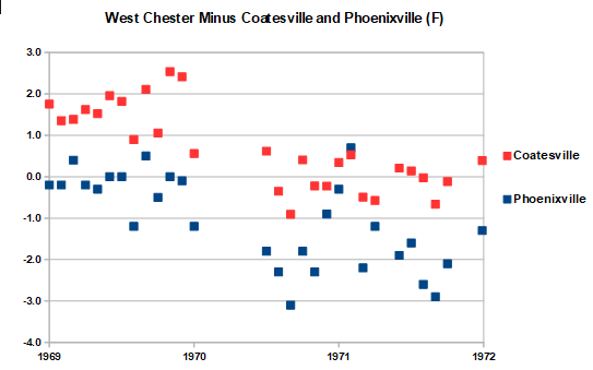
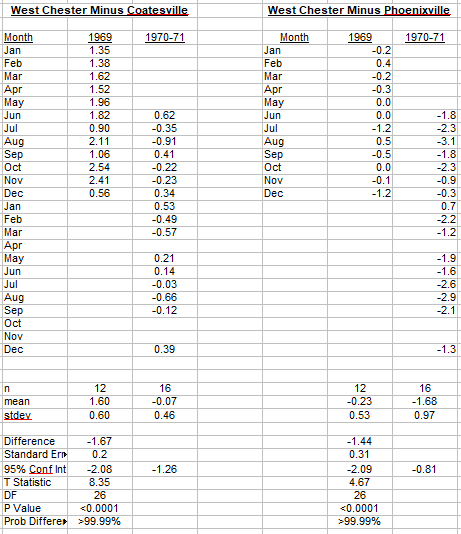
Yes stations contaminated with station changes are not suitable references. Myriad station changes are readily apparent on Paul's chart. Just look for a single station with-year-to-year movement different than the others. Between 1941 and 1975, West Chester, Phoenixville, Holtwood and Ephrata all had large station changes making them bad references for Coatesville over that period. However, there's an easy way to turn these stations from bad into good references. Use shorter time periods without station changes. The station changes only effect a small portion of any one station's 35-year record. The other years are untainted. Several examples are posted upthread. Here's another : West Chester's 1970 move using monthly data from Phoenixville and Coatesville as the reference. Both stations were stable in this 3-year period. The West Chester station closed at the end of 1969 and re-opened at a new site in May 1970. West Chester cooled immediately on reopening. The stats show a statistically significant 1.4-1.7F cooling relative to Coatesville and Phoenixville due to the move. This simple analysis only uses 2 reference stations. Many more are available outside of Chester County to further improve the power of the statistics. It is clear that the most important NCEI bias adjustments are highly statistically significant.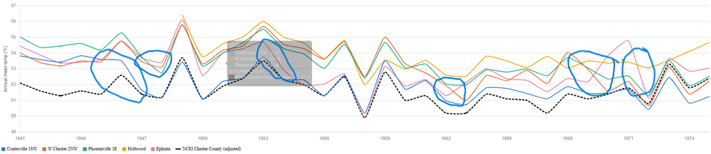
-
00z HRRR shows decent storms this afternoon, but 01-06z, it oddly has very little. The 00 and 06z RRFS is lacking in storm coverage as well. 06z 3 and 12km NAM do show plenty of tstms. Not sure what is going on here. It is not too warm aloft (700 temps 7-8 C and 1000-500 thickness 576-577), flow aloft is slightly cyclonic, and w/ temps maxing in the mid 90s and dews low-mid 70s, I see no reason why tstm coverage should not be sct-bkn. Plenty of instability CAPE 2500-3500, lapse rates better than several days ago up to 6.5 C/km at mid-levels. PWATs around 2" so big rain potential again. Winds aloft kind of MEH. So expect multicellular clusters.
- 1,723 replies
-
- 2
-
-

-
- severe
- thunderstorms
- (and 7 more)