All Activity
- Past hour
-

1/30-1/31 Lake Effect Snow Threat - SE WI, NE IL, and NW IN
ILSNOW replied to A-L-E-K's topic in Lakes/Ohio Valley
ended up with just under 2 inches here -
We don’t cut the flower beds back until spring so that the birds and the critters can enjoy them. We also have multiple birdfeeders throughout the backyard. It’s great for this time of year.
-

Central PA Winter 25/26 Discussion and Obs
canderson replied to MAG5035's topic in Upstate New York/Pennsylvania
Storm so suppressed it’s moving too far east to push stronger ones to us (thankfully) -

The “I bring the mojo” Jan 30-Feb 1 potential winter storm
Roger Smith replied to lilj4425's topic in Southeastern States
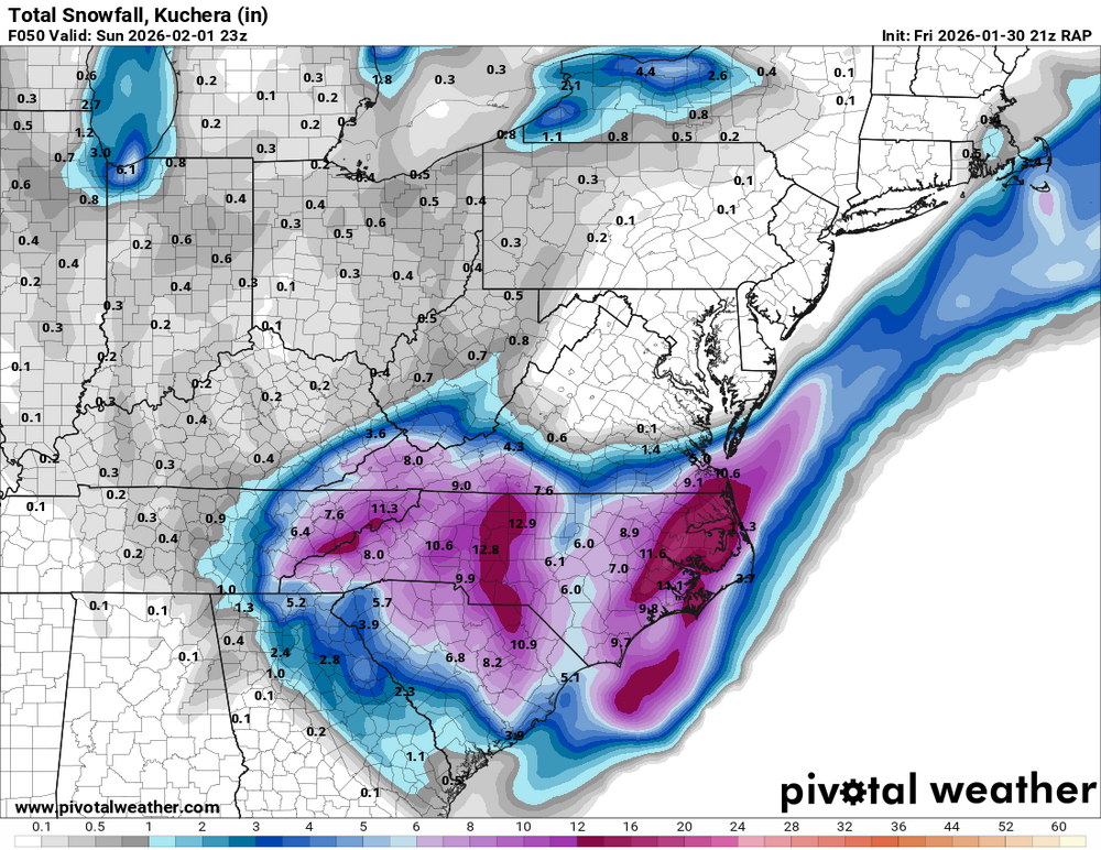
Here's how I would expect this to play out, first an interval of light to moderate snow mostly inland NC-SC-ne GA as the 500 mb low begins to deepen over GA, then an interval of heavy bands of snow along the Carolina coasts from roughly New Bern to Savannah, possibly two parallel bands with local snow maxima of 12-18 inches. Ongoing lighter snow further inland brings totals to about 6 inches. Southeast VA and northeast NC have more uncertainty, they could have an interval of blizzard like heavy snow, or the coastal may pull away too far south and too fast to give them more than 3-5 inches. Temperatures in the low to mid 20s during this snow, a few bands in eastern GA with slightly higher temps could see hail mixed with snow. Looks increasingly likely that some local bands of 0.5 to 1.0 inch snow could fall in n/c FL also. There are a lot of small to medium sized lakes there to enhance shower clouds, and temperatures by late Saturday will be below freezing as far south as Tampa to Space Center and low to mid 40s in s FL. Crazy man! -

The “I bring the mojo” Jan 30-Feb 1 potential winter storm
PenguinLover replied to lilj4425's topic in Southeastern States
Same here, I'd take those few inches of snow for me and run at this point. -

Jan 30th-February 1st 2026 Arctic Blast/ULL Snow OBS Thread.
bearman replied to John1122's topic in Tennessee Valley
Ok we got what I would call steady light snow. -

Richmond Metro/Hampton Roads Area Discussion
wasnow215 replied to RIC Airport's topic in Mid Atlantic
Both AI's slightly north-18z -

February 2026 Medium/ Long Range Discussion: Buckle Up!
T. August replied to Weather Will's topic in Mid Atlantic
Agreed… too much smoothing. Almost ensemble-esque -
Richmond Metro/Hampton Roads Area Discussion
wasnow215 replied to RIC Airport's topic in Mid Atlantic
We will see about that and how the models are handling the low placement etc. Won't know til nowcasting. -

The “I bring the mojo” Jan 30-Feb 1 potential winter storm
Snowncanes replied to lilj4425's topic in Southeastern States
The RAP dry slot can be seen here. Im not sure I would really buy into that not being moist enough for snow growth. Not sure why there’s that tiny dry pocket either. Maybe a Met could explain better than me. I think the HRRR likely has something similar going on.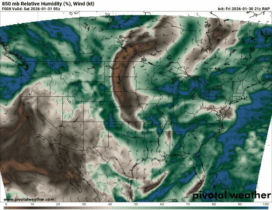
-

The “I bring the mojo” Jan 30-Feb 1 potential winter storm
ForsythWx replied to lilj4425's topic in Southeastern States
The “blank canvas” we‘re still operating with going into this snowstorm in Winston-Salem. May be hard to measure!
-
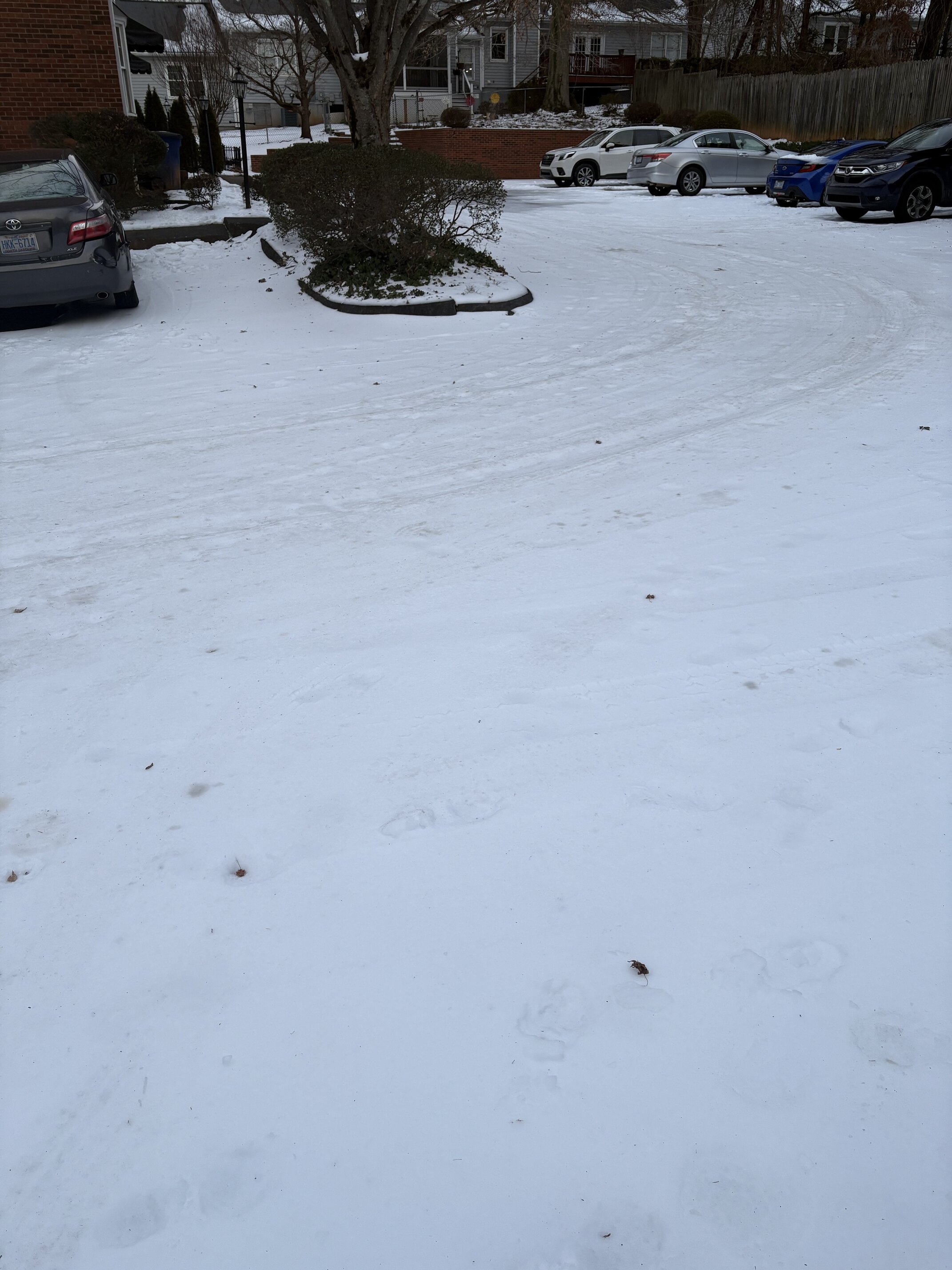
Ground already turning white here in Halls .
- 763 replies
-
- 1
-

-
- extreme cold
- snow
- (and 1 more)
-

1-30/2-1-26 Arctic Blast, ULL Snow Event
Jeff Co Vol replied to John1122's topic in Tennessee Valley
Now that the event has begun, most everyone has moved to the OBS thread. Link to the OBS thread- 763 replies
-
- 1
-
-
- extreme cold
- snow
- (and 1 more)
-

1/30-1/31 Lake Effect Snow Threat - SE WI, NE IL, and NW IN
RCNYILWX replied to A-L-E-K's topic in Lakes/Ohio Valley
Of course not following expectations once we tried to simplify the headlines - good ol' lake effect lol. The good news is that while the lakefront has been mostly whiffed since this morning, there's also lot of people in the nearby suburbs in Cook where it has been snowing hard. Curious to see how tomorrow plays out, with strong convergence but steadily decreasing inversion heights and delta Ts. Sent from my SM-S936U using Tapatalk -

The “I bring the mojo” Jan 30-Feb 1 potential winter storm
Regan replied to lilj4425's topic in Southeastern States
I missed that. Can you describe what thy said ? -

February 2026 Medium/ Long Range Discussion: Buckle Up!
mitchnick replied to Weather Will's topic in Mid Atlantic
That seems to be an AI thing. I've been noticing that on a number of both AI runs. -

1/30-1/31 Lake Effect Snow Threat - SE WI, NE IL, and NW IN
Cary67 replied to A-L-E-K's topic in Lakes/Ohio Valley
Was in Northbrook most of the day. It was ripping at times. Sad to head back to dust town -

February 2026 Medium/ Long Range Discussion: Buckle Up!
stormtracker replied to Weather Will's topic in Mid Atlantic
In this famine, I'd take it -

February 2026 Medium/ Long Range Discussion: Buckle Up!
Buddy1987 replied to Weather Will's topic in Mid Atlantic
After the GFS with this last storm, I will find it hard to believe for quite a long time. Trash model. -

Arctic Hounds Unleashed: Long Duration Late January Cold Snap
JACKASS replied to WxWatcher007's topic in New England
Agree, Yesterday morning was the coldest it's been. -10F Plus, I won't have to be out in it heading for work. -

Central PA Winter 25/26 Discussion and Obs
Jns2183 replied to MAG5035's topic in Upstate New York/Pennsylvania
On the negative side we seemed primed to waste the best two weeks of cold in a decade Sent from my SM-S731U using Tapatalk -
February 2026 Medium/ Long Range Discussion: Buckle Up!
T. August replied to Weather Will's topic in Mid Atlantic
It precipitates for like 48 hours with no panel getting over .1” lol. Yeah technically it is indeed half an inch of liquid. -

February 2026 Medium/ Long Range Discussion: Buckle Up!
Terpeast replied to Weather Will's topic in Mid Atlantic
Verification scores coming in for ai-gfs and its ensembles, ai is doing better than their dynamic counterparts. But that’s not saying much. I’d say its middle of the pack on par with op euro and geps, with ai euro leading the pack. -

The “I bring the mojo” Jan 30-Feb 1 potential winter storm
ADB83 replied to lilj4425's topic in Southeastern States
Snowier across the board? . -
New RAP