All Activity
- Past hour
-
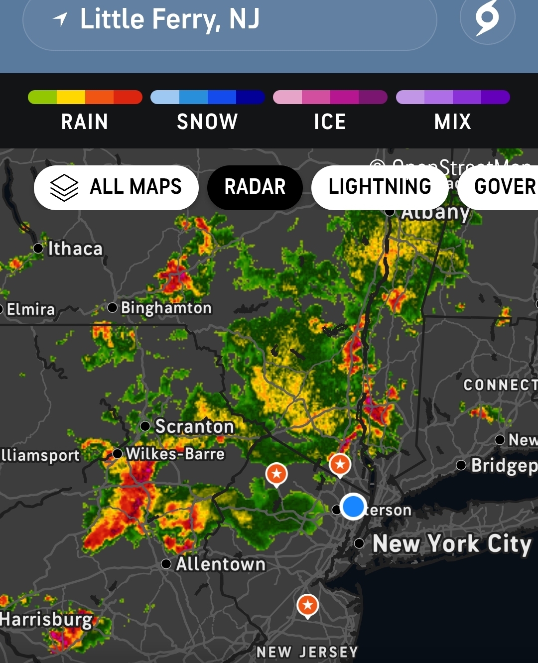
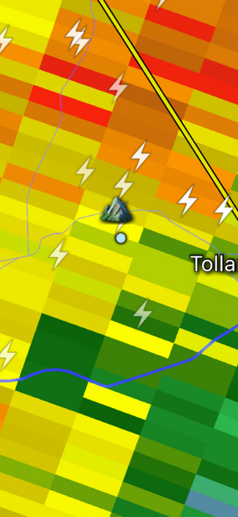
And The cell over Middlebury has not moved.
-
Simply amazing watching the rain literally move around to avoid my area.
-
Just please God don’t give this one to Canada again.
-

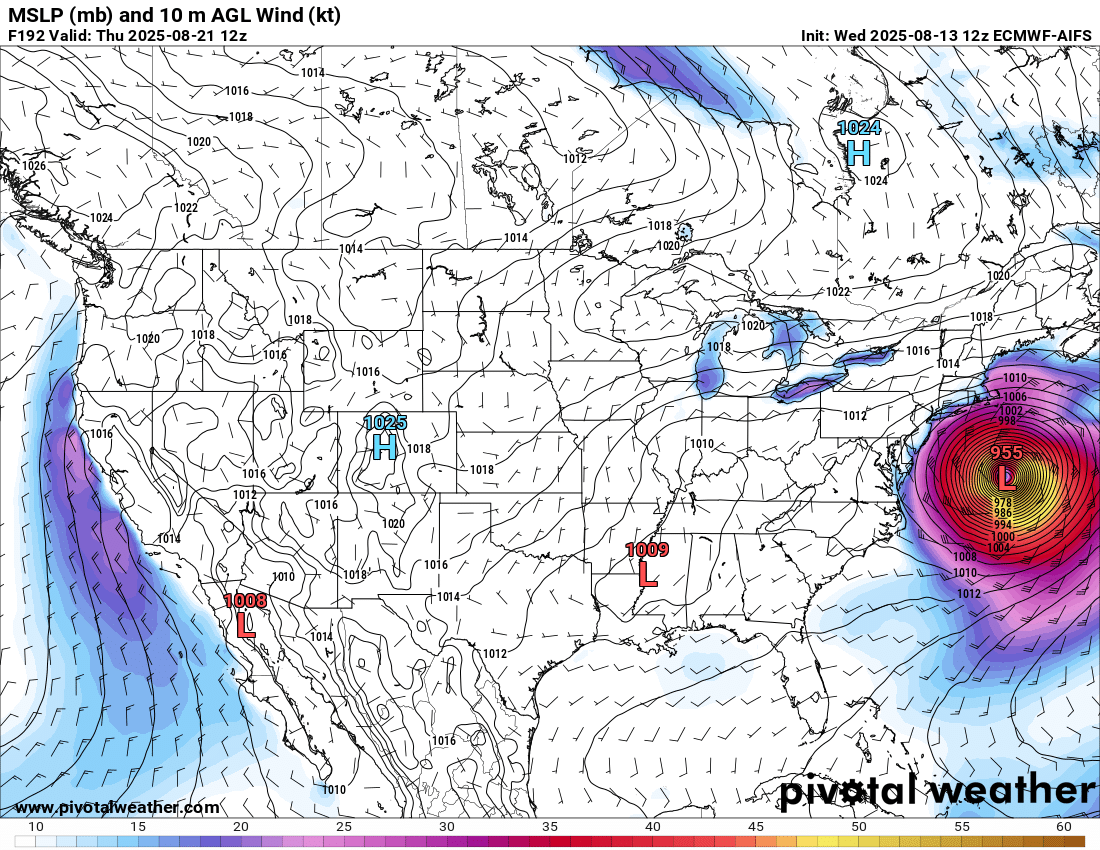
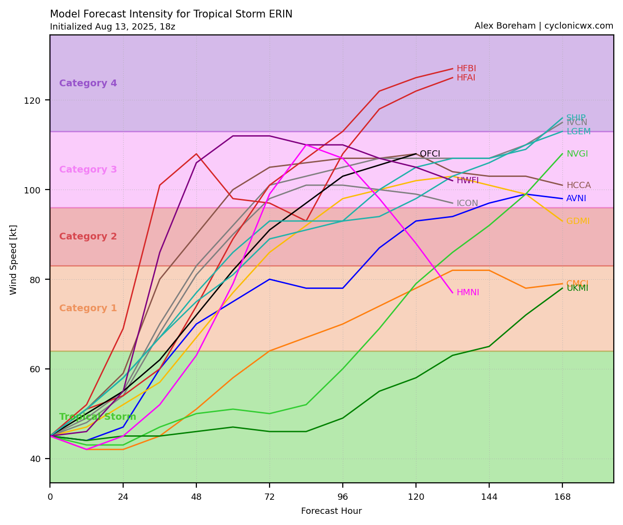
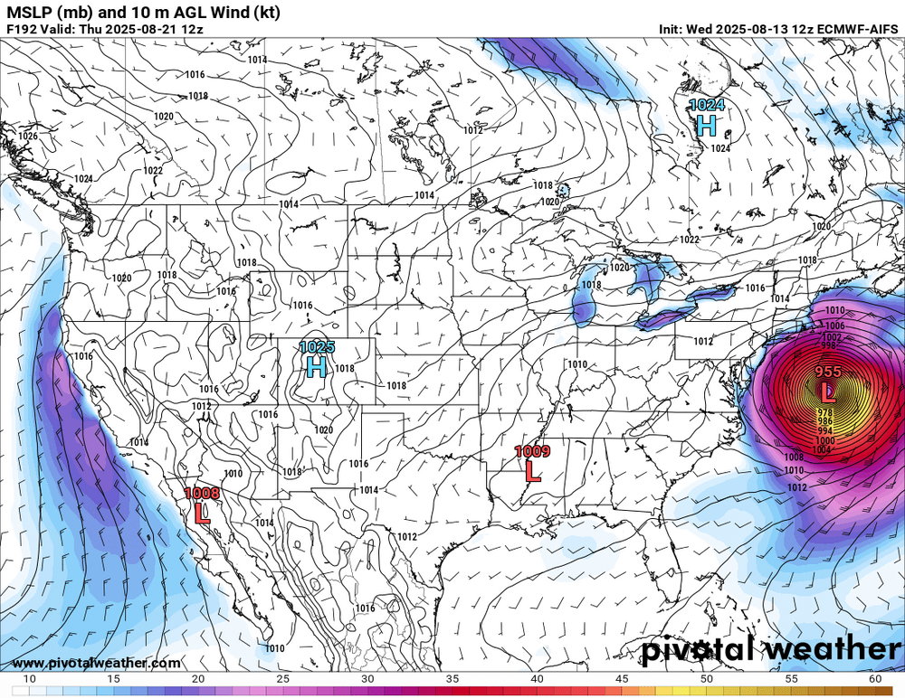
Tropical Storm Erin - NOW AT 45 KTS @ 18Z!
LongBeachSurfFreak replied to BarryStantonGBP's topic in Tropical Headquarters
Exactly as modeled that would cause some serious coastal damage on the outer banks. Wash overs and severe beach erosion. And to a lesser extent all the way to New England from swell action. I’ll pass on Erin getting that closer as the circulation would be close enough to effect local winds here on Long Island ruining the big surf for surfing. -
 We all know, the Bergen bubble will make it go northeast and southeast of my area Mother nature will slither right around in that dry slot.
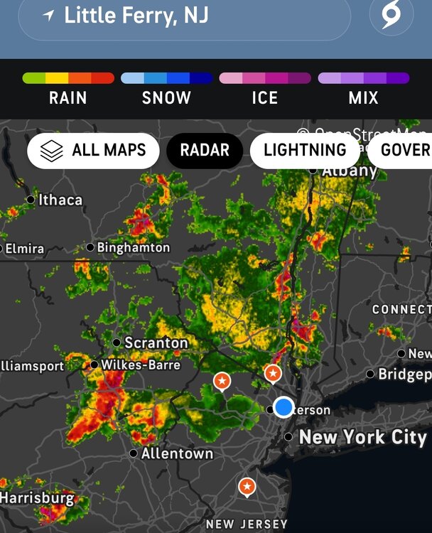
-
The farther west the track, the sharper the recurve
-
My place has had a couple of traces of rain since the beginning of the month.
-
 Those storms near Easton I'm hoping can bring some rain. It will be a close call if they hold. 91 today before the clouds moved in. 88 currently
 -

Tropical Storm Erin - NOW AT 45 KTS @ 18Z!
Chinook replied to BarryStantonGBP's topic in Tropical Headquarters
To follow up on that, here's the measurement tool (shift+drag mouse) to see this ECMWF average is approximately 250 naut. miles west of Bermuda -
You might have been onto something...looks like the humidity is simply no match for the FDK rain shadow.
-
ACATT has no idea what to say to that
-
91 for the high here. Some clouds now But heat wave #3 here. I am impressed
-
Looks awfully similar to their outlooks for 2022-2023 & 2023-2024. With that track record, I wouldn't put too much stock in it.
-
3 straight 97s for IZG. Avg max on the month of 87.5° so far.
-
Yup. Looks like a MD split unless something changes in a hurry.
-
 The upper ridge in late June was able to build into the Great Lakes and Ohio Valley. This allowed the Bermuda high at the surface to expand back west through the Apps. So it created westerly flow to the coast. This current event had the upper ridge east of New England. So the Bermuda high expanded too far north to the east of ACY allowing onshore flow. So we can probably say this was a hybrid summer alternating between 2010-2013 patterns and 2018-2024 patterns.
 -
We’ve had 3 storms this summer and all were prolific lightning producers. Stein here today with .08. Inches just to WSW
-
Just going to have to wait for Erin to begin strengthening...but I am still curious if once that happens it will end up ingesting more of this SAL. I think one saving grace for Erin right now is because it isn't overly strong and wrapped its not getting t, much, if any into the center. But its been doing much better with convection today, not a terrible looking structure but getting there.
-
-
Max 92.3° Hottest of the stretch
-

Spring 2025 Med/Long Range Discussion
KakashiHatake2000 replied to John1122's topic in Tennessee Valley
hopefully everybody is staying safe today in southeast tn but i also wanted to show the full picture of the slight and marginal risk for excessive rainfall r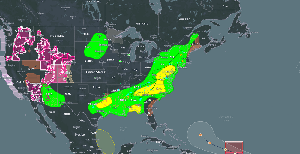
-
It looks like the NAM 3k from this morning. It had most of the heavy stuff slipping south of DC. It looks like it might be onto something.
-
being a week plus out we watch
-
Long shot but yeah, still worth watching. The UL pattern over Canada is critical to how close this gets. Note how much less aggressive the trough is in SE Canada. That has a ripple effect across the steering pattern players. 00z 12z
-

Tropical Storm Erin - NOW AT 45 KTS @ 18Z!
BarryStantonGBP replied to BarryStantonGBP's topic in Tropical Headquarters
COME ON ERIN BAM BAM BAM