All Activity
- Past hour
-
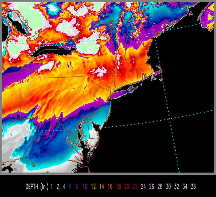
MIDNIGHT Monday HRRR keeps giving. Looking good.
-

Central PA Winter 25/26 Discussion and Obs
WmsptWx replied to MAG5035's topic in Upstate New York/Pennsylvania
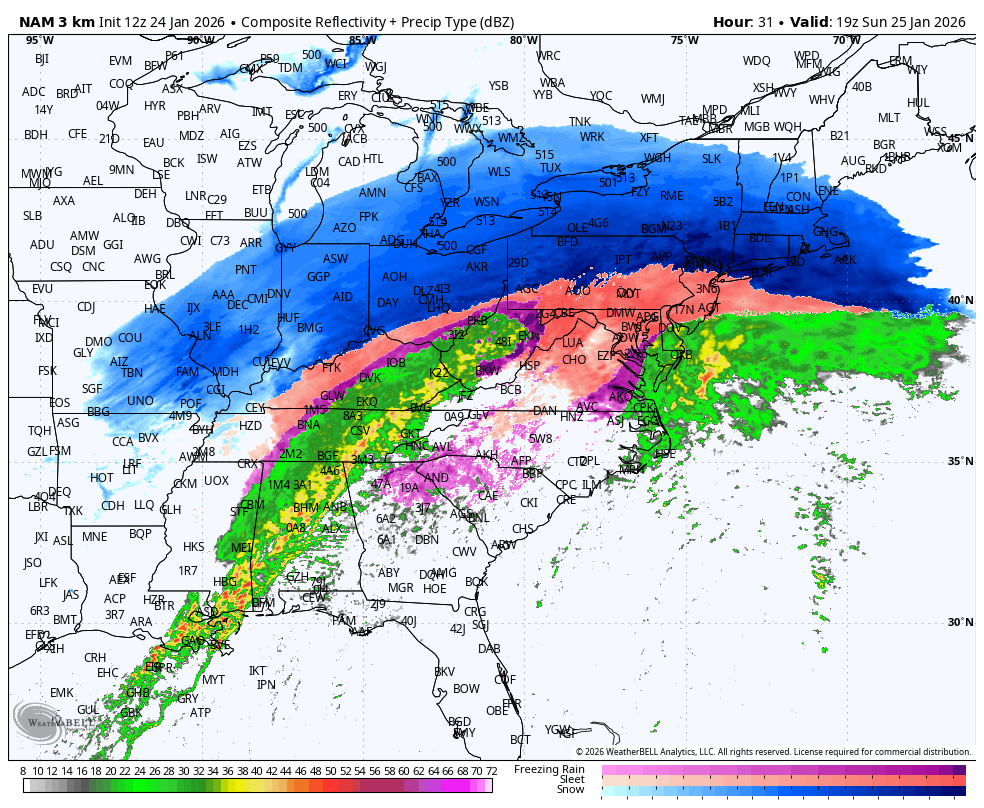
If the NAM is right, you'll probably need to shovel sleet twice to avoid throwing your back out lol. -

“Cory’s in LA! Let’s MECS!” Jan. 24-26 Disco
WxWatcher007 replied to TheSnowman's topic in New England
Bring the juice. Sling it up and in and don’t stop. -
Nam is perilously close to a ton of sleet for most of CT/RI/SE Mass.
-

1/24-1/25 Major Winter Storm - S. IL, IN, and OH
Stevo6899 replied to A-L-E-K's topic in Lakes/Ohio Valley
This is one of those where josh could get 8 inches, while my backyard gets a dusting. -

Extreme Cold, Snow & Sleet: SECS 1/25 - 1/26
MJO812 replied to TriPol's topic in New York City Metro
Sleet goes all the way up to NNJ. Nam might be too fast. Sometimes it has these wonky runs the day before. If this is correct its only a 4-8 inches snowstorm before heavy sleet. -

January 25-26 Winter Storm Potential
Hurricane Agnes replied to Ralph Wiggum's topic in Philadelphia Region
What popped in my mind is a "clash of the titans". If iy snows hard enough and the cold air clashes with the warm nose, it could get convective and maybe even produce "thundersnow". It seems all these signals for a big "thump to sleet" suggests some high in/hr before a changeover. -
Sweet. Lets get 3” of sleet
-

Jan 24-26 Weekend Snow and Sleetfest Model Thread Part Tres
baltosquid replied to H2O's topic in Mid Atlantic
FV3 still one to hang on to but it came down a bit with snow totals (except NW crew) all the same. 8-9 for the metros on kuchera vs 10-11 last run. -

Jan 24-26 Weekend Snow and Sleetfest Model Thread Part Tres
MN Transplant replied to H2O's topic in Mid Atlantic
There is less than a quarter inch of precip from changeover at 12z to 18z for many of us. -

Extreme Cold, Snow & Sleet: SECS 1/25 - 1/26
SACRUS replied to TriPol's topic in New York City Metro
-

Jan 24-26 Weekend Snow and Sleetfest Model Thread Part Tres
psuhoffman replied to H2O's topic in Mid Atlantic
24 hours ago we were debating if ice would make it to the PA line...now it's closer to the NY line -
Spending the weekend here in the Berkshires, currently -5 here, 9 above back home in HPN.
-

January 25/26 Jimbo Back Surgery Storm
Orange county replied to Jimbo!'s topic in Southeastern States
NWS says the last 3/4 to an inch will be above freezing cold rain in Raleigh -
.thumb.jpeg.f5c6ba9d911ec96b3b124f8606aee58e.jpeg)
Extreme Cold, Snow & Sleet: SECS 1/25 - 1/26
TJW014 replied to TriPol's topic in New York City Metro
Last call. Zero changes to the map from yesterday afternoon. Let's see how it goes...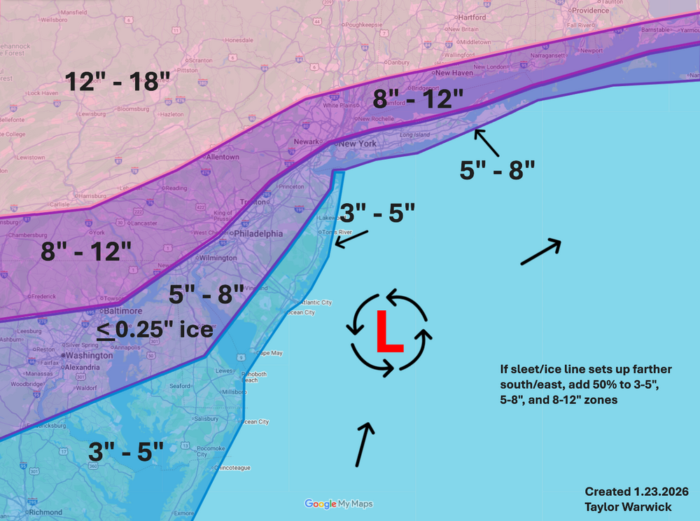
-
It is.
-

Jan 24-26 Weekend Snow and Sleetfest Model Thread Part Tres
TSSN+ replied to H2O's topic in Mid Atlantic
May be 4-6" of snow on the nam but it is also like 2-4" sleet which is worse impacts. -
As expected, the storm is ahead of schedule.
-
There isn’t a lot of science in kuchera. It’s just based on the premise that the colder the max temp in the column is, the higher the ratio will be. But there’s a point where it goes too far the other end…especially in a setup like this where the low levels are so cold. It sorta assumes normal lapse rates in a storm and not something inverted. Usually a temp of 15-20° is a sweetspot here for mid level temps in the DGZ. But if the column is sitting at 5° or colder all the way up it just keeps assuming ratios are getting higher and higher. -18°C in the growth zone is the bottom limit for dendritic crystal habit. -20°C and colder you start getting bullets that are small and accumulate more densely. Yet if you look at the estimated kuchera ratios in Canada with -30C throughout the column it tries to paint 50:1.
-

1/24-1/25 Major Winter Storm - S. IL, IN, and OH
sbnwx85 replied to A-L-E-K's topic in Lakes/Ohio Valley
Call in real jeopardy now -
No expert, but looks too big to be a house cat. I have seen a ton of bobcats down here over the past year, including a family that lives right next to my office building in a small area of woods
-

Extreme Cold, Snow & Sleet: SECS 1/25 - 1/26
allgame830 replied to TriPol's topic in New York City Metro
Im sorry but rates that high as the NAM is showing the changeover is way to aggressive! -

Extreme Cold, Snow & Sleet: SECS 1/25 - 1/26
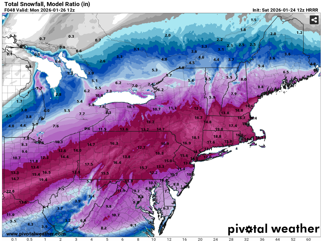
donsutherland1 replied to TriPol's topic in New York City Metro
Here's the HRRR's total snowfall map using the model's own assessment of the snow-liquid ratio:
-

Jan 24-26 Weekend Snow and Sleetfest Model Thread Part Tres
Weather Will replied to H2O's topic in Mid Atlantic
WB 3K NAM also looks to dry slot with a period of freezing drizzle/ sleet by Sunday afternoon.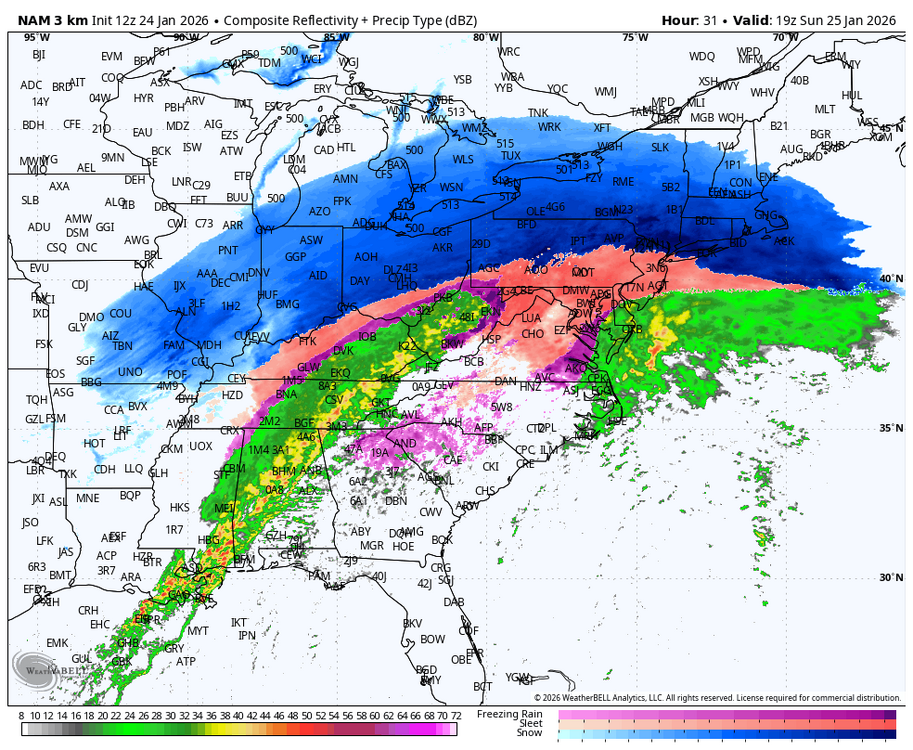
-

Jan 24-26 Weekend Snow and Sleetfest Model Thread Part Tres
mitchnick replied to H2O's topic in Mid Atlantic
3k as bad as 12k....maybe worse if you can believe it. And I know you can!