All Activity
- Past hour
-
-
Yea I can still workout in wind pants. I’d like it to be warmer, but the sunshine today is top shelf.
-
This weather is a Bob Ross painting.
-
Yes, the low humidity has been fantastic for the lawn. No brown patch or fungus issues with temps and humidity like this.
-
It’s perfect out there right now!
-
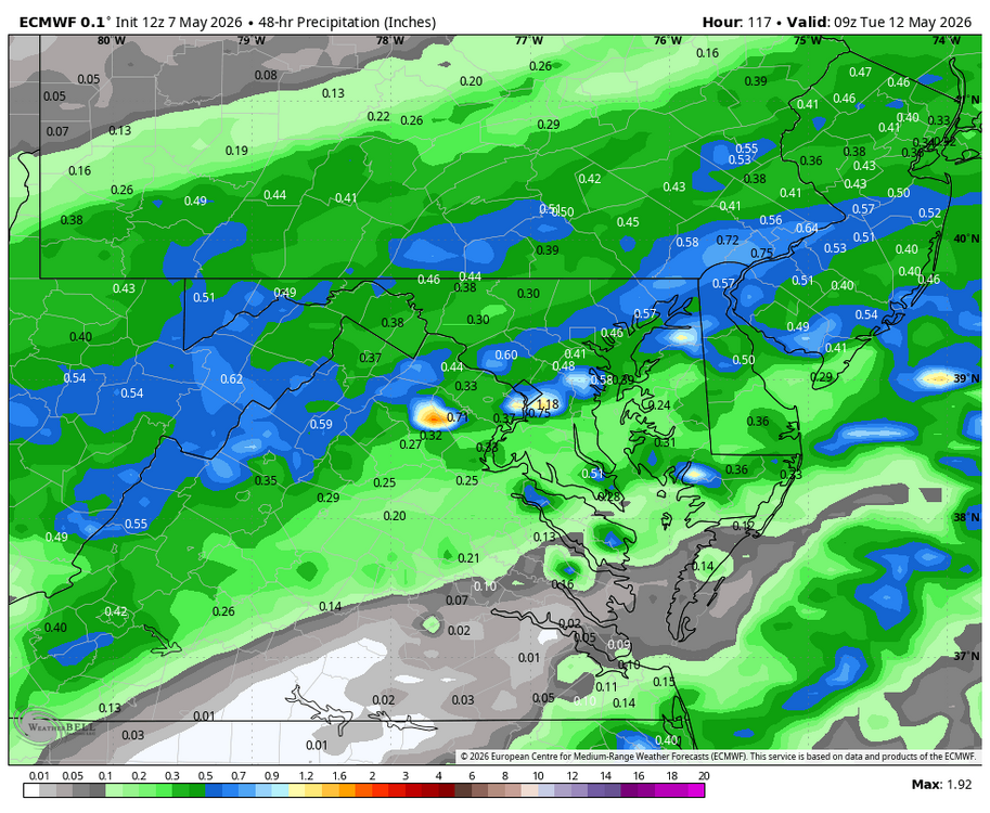
Haha I’ll blame something. Southern wake got over 1.5” radar estimate. This is still our biggest rain in forever
-
I'm ready for shorts weather. My hoodies and sweatpants are getting worn out.
-

Spring 2026 Pattern Discussion Thread
Carvers Gap replied to Carvers Gap's topic in Tennessee Valley
More patchy frost tonight over the northern valley into SW VA. This is getting old fast(covering up stuff)! These temps have been steadily going in reverse since those mid-80s summertime, bluebird days a few weeks ago! 57F at TRI right now. Feels like February. - Today
-
Haven't gotten into permethrin yet, just vigilance once I'm back inside. Worked all but once; in November 2022 one found a hiding place in the short hairs and had a drink. It was quickly dispatched but only after infecting me with anaplasmosis, which messed with my balance and eyesight along with making me feel awful. Doxy to the rescue. 10 AM thru 12:30 was spent on the woodlot, with its abundant horizontal fir (thanks to Dec 18, 2023), also wandered thru the cedar swamp, a cool area in both senses. Only found one tick so far, likely a couple will turn up to be squashed. Great day to be in the woods, except for the black flies. They're still only checking the menu, but also checking out eyes and ear canals.
-
Had some heavy rains form overnight as a line came through. Walking out to the chilly air felt great!
-
Blame the gravity waves.
-
0.48" for the day here. A nice surprise, as was expecting a few tenths at best.
-

2026-2027 Strong/Super El Nino
csnavywx replied to Stormchaserchuck1's topic in Weather Forecasting and Discussion
Given how the following month went in pumping all of that WWV eastward and the sheer amount of momentum transfer into the thermocline, I will make the following statement: Never short sell synoptically obvious events. -
2026-2027 Strong/Super El Nino
csnavywx replied to Stormchaserchuck1's topic in Weather Forecasting and Discussion
It's a nice theory, but there's reason to believe cooling caused by tropical volcanic eruptions actually help weaken trades over the WPac: https://www.sciencedaily.com/releases/2017/10/171003111101.htm So it's debatable whether that Nino even happens in the first place, or if it does, to that degree. -

E PA/NJ/DE Spring 2026 Obs/Discussion
JTA66 replied to PhiEaglesfan712's topic in Philadelphia Region
How come wrap-around snows never work out like that?? -
Another underperformer in Raleigh, though we’re at 0.68” including yesterday’s shower. Good rain but was pretty certain we’d get at least an inch given forecasts and models. MTD 0.82” which equals our entire month of April rainfall here. It’s still raining a little so these are not final totals
-
WB 12Z EURO for late Sunday/Monday.
-

Central PA Spring 2026 Discussion/Obs Thread
WmsptWx replied to Voyager's topic in Upstate New York/Pennsylvania
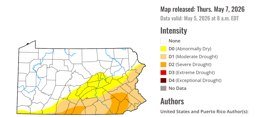
It has barely rained in those areas. -
Added climate normals Cocorahs reports and radar
-

Central PA Spring 2026 Discussion/Obs Thread
Ruin replied to Voyager's topic in Upstate New York/Pennsylvania
still the same bs map they havent updated it tho they claim they have -
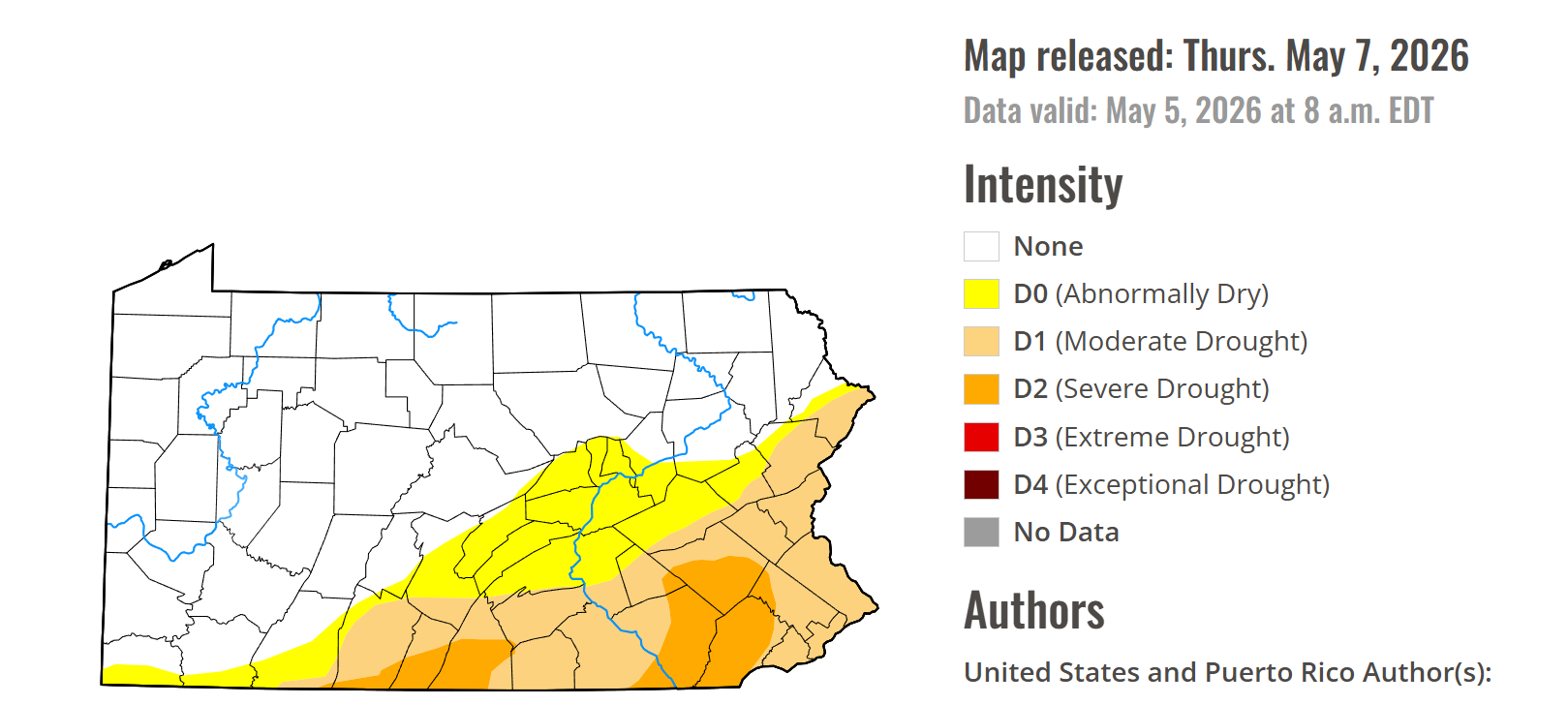
Yes, it is now EXTREME DROUGHT For Waynesboro.
-
Central PA Spring 2026 Discussion/Obs Thread
Ruin replied to Voyager's topic in Upstate New York/Pennsylvania
-
-
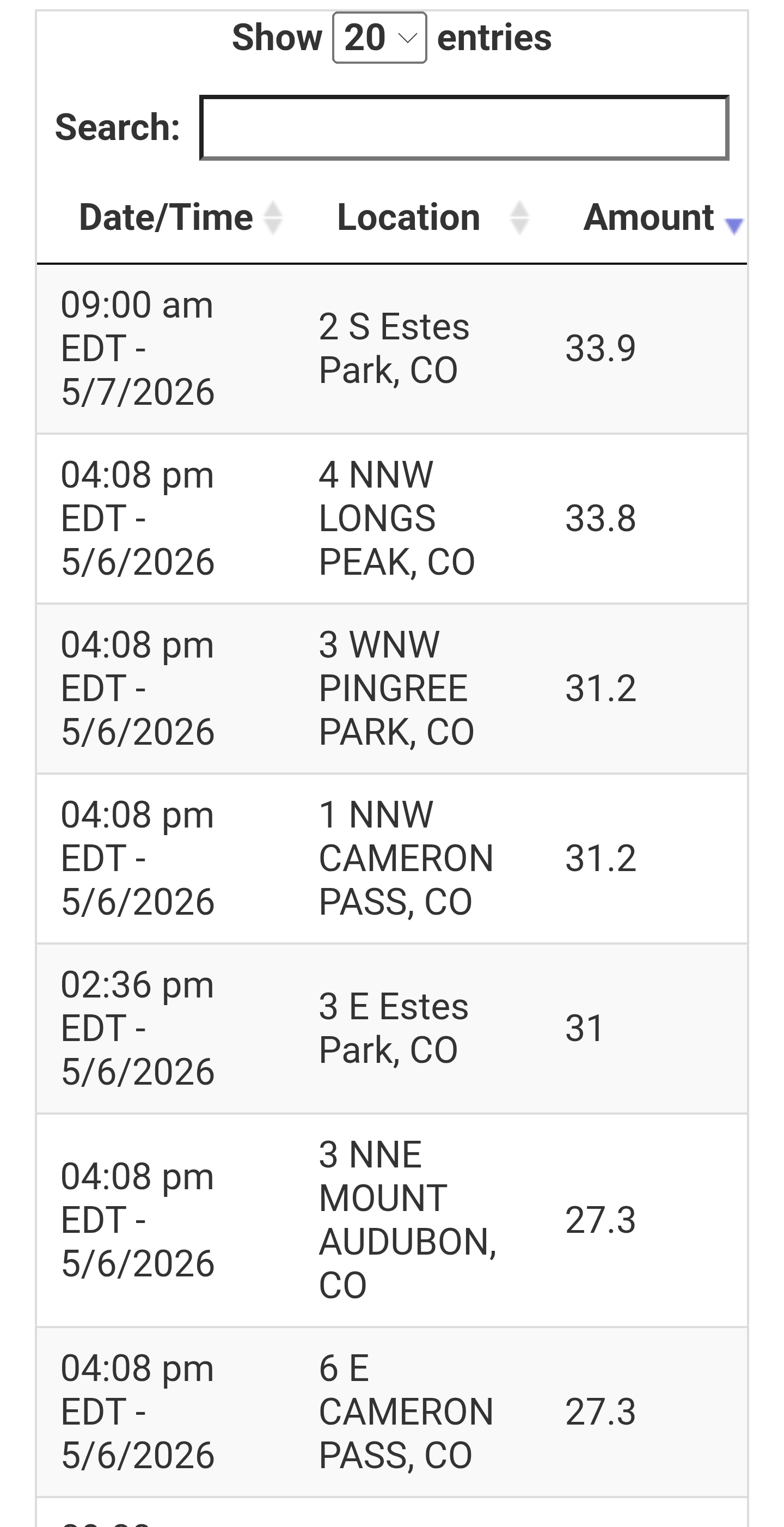
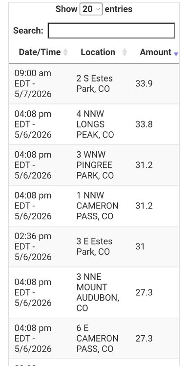
So for the DEN snowstorm... Max measured amount I could find was 33.9" 1.8 S Estes Park (about 8000 ft). Max estimated from SNOTEL was 33.8" 4 NNW Long Peak (about 9100 ft). HRRR fcst snow totals were over 40" and odds are that did indeed occur above 10,000 (hard to verify tho since no in situ obs). Global models fcst max amounts just over 30" in the highest elevations w/ their lower resolution for terrain, so a great fcst overall for the absolute highest amounts. Yes, not a drought buster, but quite significant snowfall event w/ high LEQs, so this can only help. You can choose to look at things glass half empty or full. Emphasize the negative or positive. Just the MSM tends to focus on the negative, which is nothing new really, but social media and overall divide these days often amplifies it to the extreme w/ context and perspective lacking. Denver officially had 5.8" but the climate location is 16 mi ENE of the downtown. SW suburbs had up to 9.5". Also, it seems that May snowstorms ranking for Denver is all over the place on social media. https://kdvr.com/weather/wx-news/this-may-snowstorm-is-one-of-the-largest-in-denver-history/ The above link lists the biggest snowfalls for the city and it is inclusive for the 3 different locations where snow has been measured (earliest event listed is 1931). It states this most recent snowstorm was the 5th biggest in the city's history, but that is incorrect. It leaves out 12.4" on May 5-6, 1978 and May 13-14, and 15.5" May 1-5, 1898. And when I have mentioned this on social media posts, ppl have said, "that's what the NWS provided to me." Yet you go on the NWS BOU site, and the 3 May snowstorms I just mentioned are listed. NWS Boulder Denver Top 20 Records - May It just goes to show how easily bad or incorrect information can spread. Too many media outlets and individuals just parrot what others say and do no fact-checking themselves! This is important in the large pix when talking about wx and climate b/c the details count and can make a big difference in stories/statements.
-
I assumed the faucet would turn off and it very well may have already. I hope not.