All Activity
- Past hour
-
4” of snow this weekend and I’d give the winter an A. 6” and it’s an A+ and best in at least a decade.
-

1-30/2-1-26 Arctic Blast, ULL Snow Event
Holston_River_Rambler replied to John1122's topic in Tennessee Valley
Rug pull watch may be warranted later today.- 25 replies
-
- 1
-

-
- extreme cold
- snow
- (and 1 more)
-

Possible coastal storm centered on Feb 1 2026.
HoarfrostHubb replied to Typhoon Tip's topic in New England
I would not hate on a 6-8” snowfall here Sunday. (Although ratios would be lower than some of the fluff we’ve been getting this winter here) -

Winter 2025-26 Medium/Long Range Discussion
Cary67 replied to michsnowfreak's topic in Lakes/Ohio Valley
Hopefully. This weekend is duster event #9 for my area -

Possible coastal storm centered on Feb 1 2026.
40/70 Benchmark replied to Typhoon Tip's topic in New England
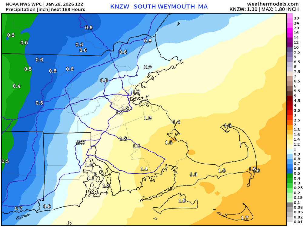
0.7". Thanks. -

Possible coastal storm centered on Feb 1 2026.
Ginx snewx replied to Typhoon Tip's topic in New England
-
1-30/2-1-26 Arctic Blast, ULL Snow Event
Holston_River_Rambler replied to John1122's topic in Tennessee Valley
If I lived in some place like NYC of Boston, I'd be pretty pissed at that guy for posting something like that. I think 90th percentile means it is higher than 90 percent of all samples in the analog set. Here's what the same analog set has for percentage on sites getting greater then 4". I don't mean this in any way as a dig at you Powell, I just think that guy is farming for clicks from high population center snow weenies. -
Possible coastal storm centered on Feb 1 2026.
40/70 Benchmark replied to Typhoon Tip's topic in New England
Even that QPF chart, as is, argues for prolific deformation from like Steve up through my area here in the MRV....crude rule of thumb is right near the QPF gradient, which at this range is only detecting lower level forcing. -

The Jan 31 Potential: Stormtracker Failure or 'Tracker Trouncing
osfan24 replied to stormtracker's topic in Mid Atlantic
I still say this is exactly what I picture for a Niña. -
The 06Z NAM is too good to be true. Even a quasi-trowal to help keep snow in Tenn. If that's busts it'll be the biggest NAM job in quite a while. Going high risk 60% hatched of disappointment. Otherwise globals keep light snow and snow showers northeast, Plateau, Mountains, the usual. 12Z and AI commentary will be in a few hours. My NAM cynicism aside, models overnight look OK.
-

E PA/NJ/DE Winter 2025-26 Obs/Discussion
Newman replied to LVblizzard's topic in Philadelphia Region
The models didn't trend as sharply as we needed them to last night tbh. This threat is not dead yet, but we're going to really need some dramatic shifts north with where the low closes off and the confluence over New England. I think back to the system in the middle of this month that had the models sending NS energy way south and cutting off over the TN valley. Well it ended up cutting off over the Great Lakes... The models were too "dig" happy. Different setup here with the decaying block pushing everything south, but we'll see -

Possible coastal storm centered on Feb 1 2026.
ORH_wxman replied to Typhoon Tip's topic in New England
Half of the MBTA trains stopped working that winter. It was a disaster commuting on the train into Boston. I had my office in the seaport that winter. Seaport was prob ground zero though, lol. I remember that one mesoscale event in mid-February (not the 2/15 storm) where there was this very narrow band of snow hugging the coast. Like back bay was sunny I think and when we got to south station, it was almost a whiteout. They had like 3-4” of feathers on the seaport. -
Nope
-

The Jan 31 Potential: Stormtracker Failure or 'Tracker Trouncing
WxUSAF replied to stormtracker's topic in Mid Atlantic
Yeah, agreed. I thought we'd start seeing this tick north by now. We'll see. -
Possible coastal storm centered on Feb 1 2026.
40/70 Benchmark replied to Typhoon Tip's topic in New England
Looks like 0.6" here? Do you slightly further N? TIA. -

The “I bring the mojo” Jan 30-Feb 1 potential winter storm
SUNYGRAD replied to lilj4425's topic in Southeastern States
Not a bad forecast considering all of the available data. -

The “I bring the mojo” Jan 30-Feb 1 potential winter storm
olafminesaw replied to lilj4425's topic in Southeastern States
Hope it works out better than this one (in all seriousness, that's a pretty reasonable map all things considered).jpeg.7bf614b5371aac9fd26a846d17260674.jpeg)
-

The Jan 31 Potential: Stormtracker Failure or 'Tracker Trouncing
Solution Man replied to stormtracker's topic in Mid Atlantic
Thanks, this answers my earlier question -

Possible coastal storm centered on Feb 1 2026.
dendrite replied to Typhoon Tip's topic in New England
The resolution is probably just too coarse. In a vacuum the upper levels look really good during the weekend…hence the analog storms. -
I encountered ice fog last night driving through Florida/warwick area. Current temp at the time was 9. It came out of no where & couldn’t see more than 2 feet in front of me. Impressive
-

Central PA Winter 25/26 Discussion and Obs
WmsptWx replied to MAG5035's topic in Upstate New York/Pennsylvania
Bottom dropped out. Negative three now in Three Springs. -
Somehow i missed your comment lol .
-
Possible coastal storm centered on Feb 1 2026.
40/70 Benchmark replied to Typhoon Tip's topic in New England
Do you feel dirty? -

Possible coastal storm centered on Feb 1 2026.
CoastalWx replied to Typhoon Tip's topic in New England
Now imagine 2015 lol. Your comments remind me of my wife and how she was losing it with the logistics getting to and from Northeastern U.


