All Activity
- Past hour
-
With no context is that good? What’s the differences?
-

Pittsburgh/Western PA WINTER ‘25/‘26
Rd9108 replied to Burghblizz's topic in Upstate New York/Pennsylvania
From another Met The good news is the GEFS mean phases the shortwave over the Midwest - very possible we just had a bad GFS run that will correct in 6 hours -
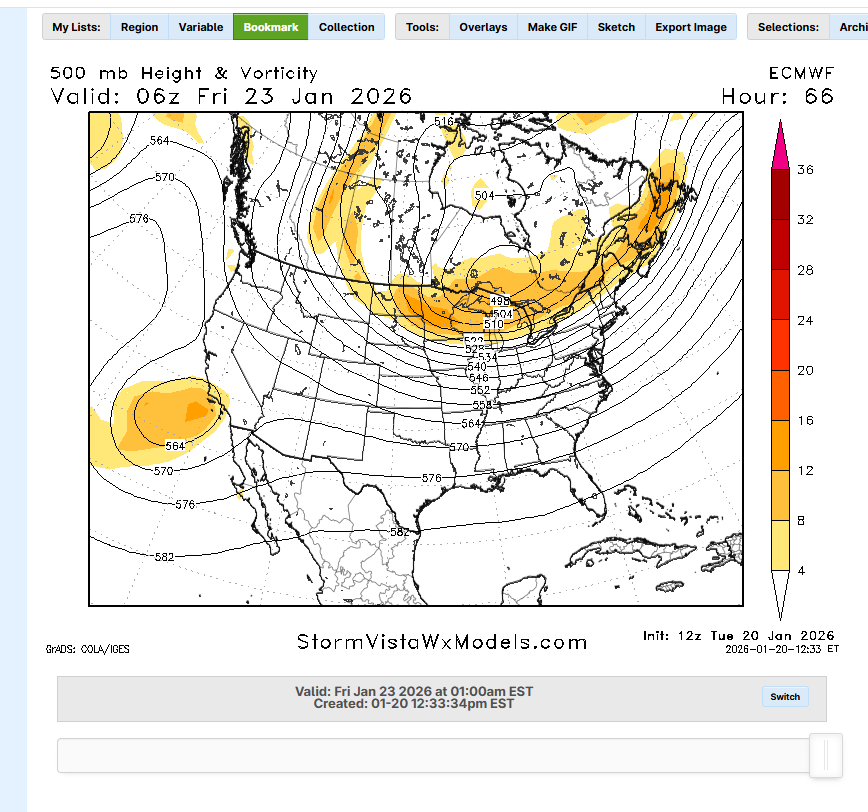
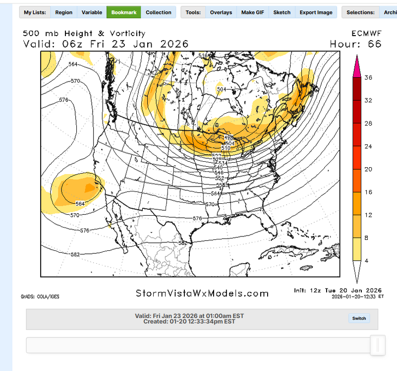
Ralph says held the line, Paul says crept south? Who to believe
-
At H5 I think it was a step back. It phases in some northern stream energy but then leaves it all behind. 6z phased it all together. Good to see even in that scenario we get a great storm. But 6z was definitely better aloft.
-
Yup. Nothing major. Best snowstorm for many in a decade and it's warning level for everyone with no precip issues.
-
-
My youngest - studying for their Masters in Galway, Ireland - had a really nice light show from this last night.
-

January 2026 regional war/obs/disco thread
Lucy Pull replied to Baroclinic Zone's topic in New England
It’s waffling quite a lot at H5 the past few runs. Results are similar to an extent but I definitely like 06z H5 for a bigger event. -

January 25-26 Winter Storm Potential
Birds~69 replied to Ralph Wiggum's topic in Philadelphia Region
Lol, what a coincidence. Hopefully we get a good storm where limbs would fall and we would hear more wood choppers. No doubt, feet. Head first would be way too easy/quick... -
Think this will be a little south of last run
-

Possible Record Breaking Cold + Snow 1/25 - 1/26
eduggs replied to TriPol's topic in New York City Metro
Everything is dependent on the height field orientation and evolution. The cold air is in place to the north. There is ample moisture to the south. If the isoheight lines are oriented mostly west to east (zonal) on Sat & Sun from North Texas to North Carolina (e.g., GFS), then this is likely a southeast and mid-Atl snowstorm. If the isoheight lines evolve with more of a north-facing component (meridional), the moisture will track further north. The more meridional the height field, the more QPF we will likely get up in our region. The placement of surface features (highs, lows, precip. field) are a reflection of the mid-and upper-level height field. To get a favorable height field we need the ULL to eject east and a favorably timed northern stream shortwave to partially or fully phase. -

Possible Record Breaking Cold + Snow 1/25 - 1/26
SACRUS replied to TriPol's topic in New York City Metro
Updated with the Euro coming now -

January 24-25: Miracle or Mirage
SomeguyfromTakomaPark replied to stormtracker's topic in Mid Atlantic
EURO AI basically noise level changes, still a great MSLP track for us and potential upside if it can slow down and get some coastal influence. -
@John1122do you believe the warm nose with such a strong HP NW of us? And do models account for dynamic cooling through the column?
-

Possible Record Breaking Cold + Snow 1/25 - 1/26
EastonSN+ replied to TriPol's topic in New York City Metro
So the ec-aifs WAS further north, however, the storm escaped out faster so less QPF. -

January 2026 regional war/obs/disco thread
Damage In Tolland replied to Baroclinic Zone's topic in New England
Beer? -
For once I agree - we need only one person doing PBP. the CMC and GFS were a disaster to read/follow this AM.
-
(002).thumb.png.6e3d9d46bca5fe41aab7a74871dd8af8.png)
January 25-26 Winter Storm Potential
ChescoWx replied to Ralph Wiggum's topic in Philadelphia Region
The latest European AI slipped south cutting snow totals almost in half across PA -
The issue we also seem to have is that the speed of movement is missed on models. That speed = how much snow falls. They tend to be longer on the runs than in actuality (My Deb downer hat is on today!)
-
Baja a bit west on Euro
-
I don’t think at your age you have ass hair.
-
Possible Record Breaking Cold + Snow 1/25 - 1/26
SACRUS replied to TriPol's topic in New York City Metro
Euro AI AIFS Total QPF -
Possible Record Breaking Cold + Snow 1/25 - 1/26
EastonSN+ replied to TriPol's topic in New York City Metro
Actually further north with the overruning but less overall QPF on the northern tier of the forum. -
It's going to be a huge ice storm towards the southern border it appears, as 850s approach almost exactly I-40 in Knoxville but stay at 33ish longer near Chattanooga but surface temps stay in the 20s in Chattanooga.
-

January 2026 regional war/obs/disco thread
Spanks45 replied to Baroclinic Zone's topic in New England
We are at the point in most winter system potentials where certain posters/meteorologists have already decided what will happen. So, for example....if they have decided this is not a SNE system, they will cherry pick the model that backs their forecast regardless of what consensus is. It is hard to distinguish it from true forecasting or just straight trolling. It goes both ways too....always adds some flavor or angst to the discussion.