All Activity
- Past hour
-
Been reading Tip for 20 years. He gets the limitations of the teleconnections. Just pointing out the lag time between a strong shortwave traversing the region from upper plains to maritime.
-

Central PA Summer 2026 Discussion/Obs Thread
canderson replied to Voyager's topic in Upstate New York/Pennsylvania
It’ll be higher in the NW area but big winds for sure -
Hopefully it rains so hard none of it soaks in
-
Stick? Ground is too warm.
-
not gonna interject but I think Tip gets it but FIGHT!!!!
-

2026 Mid-Atlantic Severe Storm General Discussion
Stormchaserchuck1 replied to Kmlwx's topic in Mid Atlantic
I notice the CPC doesn't even use AI models in their long range forecast, and I can verify that they don't have much skill at that range. EPS is probably still the way to go Saying "AI is the way to go" just makes you look smart imo, not a huge leap from previous models -
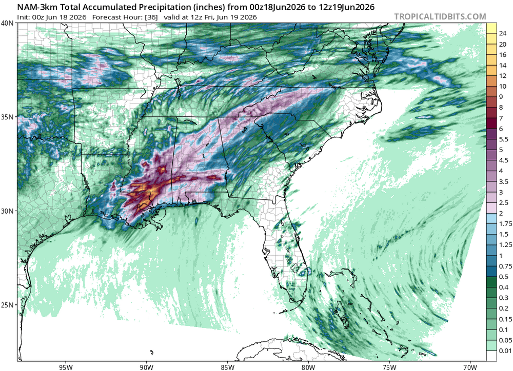
Yeah There will be some heavy showers, the smoothed out look does not reflect the ground-truth. There will be haves and have-nots obviously
-
Late May/June 2026 Medium/Long Range
Stormchaserchuck1 replied to JenkinsJinkies's topic in Mid Atlantic
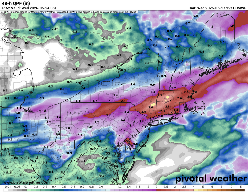
PNA is finally going positive for the first time since early May, for the 2nd half of June. June as a whole will end up being the 5th consecutive month of -PNA though -
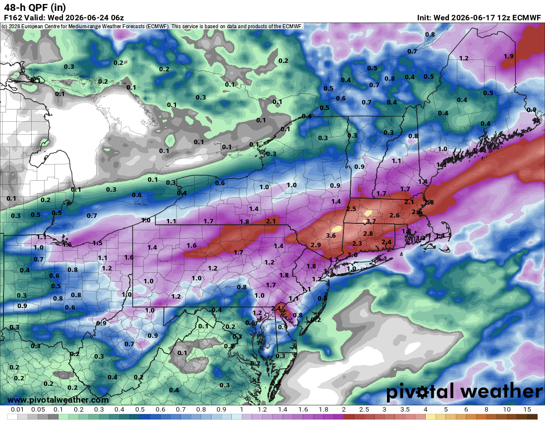
I don't know about that- not 100% anyway - seems like at least some decent showers will roll through. I'd wager at least .50 for your locale, but is real
-
You are missing the point. Teleconnections deal w/ broad scale patterns. That only works/is useful to a point. When it comes to actual sensible wx in a specific area, that's an entirely different ballgame. How many times do we have a -NAO, and no big East Coast snowstorm occurs, as one example? I pointed the mesoscale details being everything for all to read here, and learn something from it. You look on social media, and far too often you see people hyping certain patterns, and stating this or that will happen in X or Y region w/o stating any caveats or how it's not so simple/linear as a 1-1 correlation. People this forum, some are still learning and other are eager to learn more, and furthering the discussion is of value net-net. And in New England, many just think about the outbreak sequence June 8-9, 1953. That is a high-end, outlier exception, and that can skew the perception of things from a local bias POV.
-
i think that southern one will stay south of 275, but the northern one could potentially impact the metro
-
Seems that the Nino is already effecting the 500 look next week to late month.
-
certainly hope not. those cells could split the metro but any rightward movement will bring the southern of the two cells too close for comfort.
-
0z NAM said, I'll just shoot way north!
-

Central PA Summer 2026 Discussion/Obs Thread
mahantango#1 replied to Voyager's topic in Upstate New York/Pennsylvania
I presume we will get a wind report from the 'burg -
even with the consistent stratiform stuff here, thinking it could be a busy next few hours, given whats unfolded to my west
-
There is a 24 hour tele connector that exists because it’s statistically significant that’s all I’m gonna say I honestly don’t need the meteorology lesson
-
That cell is very disorganized, hopefully it doesn’t come back
-
That cell is probably about to cycle and put down another monster
-

E PA/NJ/DE Summer 2026 Obs/Discussion
RedSky replied to PhiEaglesfan712's topic in Philadelphia Region
18z goofus was well north with the monday chance -
just gonna leave this here, for now.

-
Is this thing throwing debris 5-10 miles away? Is that what's showing on radar?
-
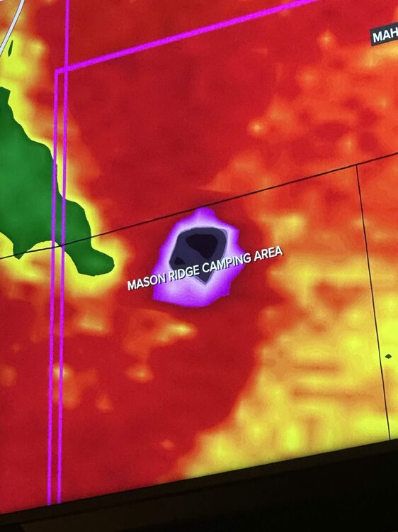
Looks like it direct hit a campground
-

Central PA Summer 2026 Discussion/Obs Thread
Jns2183 replied to Voyager's topic in Upstate New York/Pennsylvania
Watching the Great outdoors I am one with the racoons Sent from my SM-S731U using Tapatalk
- Today
-
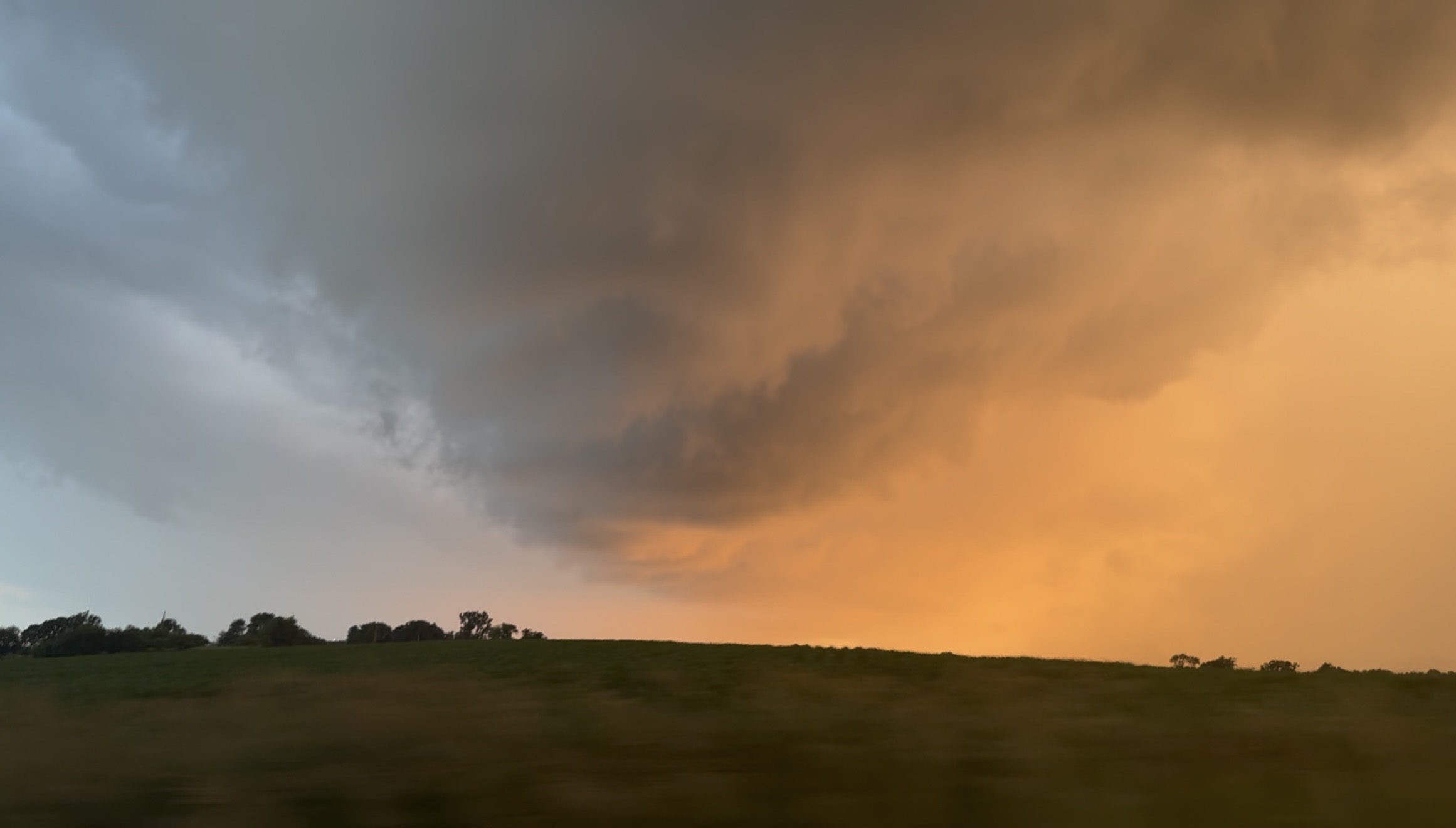
Still from video I took of the warned rotation in the notch in SE Rock County WI around a half hour ago, the greened up corn + the sunset made it majestic.


.thumb.gif.f92b16c631a1d15d405ed77b33f0710d.gif)


.thumb.jpg.ad3a2e31d30aff035044689b311a0540.jpg)


.thumb.jpg.5af6c8520bd26ab0d13e24b2747484e1.jpg)