All Activity
- Past hour
-
there's been a signal for about a week now, favoring next week for a ridge to poke up into the region. i wouldn't say it'll be a heat-wave, but it looks to be deep summer-like.
-

Junorch obs and discussion 2026
Damage In Tolland replied to Damage In Tolland's topic in New England
Will never , ever wear a mask for anything -
Mask up.
-

Central PA Summer 2026 Discussion/Obs Thread
canderson replied to Voyager's topic in Upstate New York/Pennsylvania
82 for the high today. 90s until Monday, a day in the mid 70s, then back to AN fur as long as the eye can see. -
Yep. As much as it sucked it's good we got the rains over Memorial Day Weekend. Here on out we rely on daytime T-storms or whatever organized T-storms, or tropical system which will be rare during this oncoming very strong Nino. Lawns will be crispy in a few weeks.
-
Torch incoming?
-
It's locked in. Just like the wet period this month, I've got a good feeling.
-
pine peaked here a few days ago..seems a bit better today
-
Falls lake is falling about 18” a month right now, and over last 3 days the rate has increased from about .5 to .7” a day
-
What an awesome day! Felt almost cool in the shade with the breeze. Probably the last day like this until September.
-
A warming trend is now underway. Tomorrow should see temperatures top out in lower 80s and perhaps middle 80s. Friday and Saturday will be very warm days with highs in the upper 80s and lower 90s. Should Central Park reach 90°, 2026 would become the first year on record that New York City had a high of 80° or above in March and highs of 90° or above in April, May, and June. Saturday will remain warm before somewhat cooler air arrives to conclude the weekend. The ENSO Region 1+2 anomaly was +2.2°C and the Region 3.4 anomaly was +1.0°C for the week centered around May 27. For the past six weeks, the ENSO Region 1+2 anomaly has averaged +1.80°C and the ENSO Region 3.4 anomaly has averaged +0.90°C. The ongoing El Niño will continue to strengthen through the summer. The SOI was -34.80 today. The preliminary Arctic Oscillation (AO) was +1.384 today.
-
Finally got a solid storm (and hail that was appreciably small) today. My yard was due after all the storms spinning up all around me the last week or so.
- Today
-
Where's my invite?
-
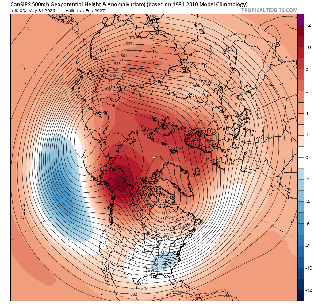
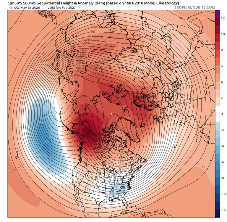
You didn't post h5 for Feb. The time for an east coast historic blizzard. +PNA, -EPO and -NAO.
-
it might be but this isn't
-
Junorch obs and discussion 2026
Damage In Tolland replied to Damage In Tolland's topic in New England
Well the NAM is discontinued -
Yeah... it's the yellow shit. I think that's pine ?
-
Getting hot for couple days this weekend and then quickly back into 70’s for highs. 2003 and 2015 prominent analogs
-
I'd watch for models to continue speeding up with the timing. There certainly could be a bit cutoff though within SNE where WOR is favored. Seeing the 18z NAM come in even quicker is something to watch...typically the NAM can be too slow.
-
Junorch obs and discussion 2026
Damage In Tolland replied to Damage In Tolland's topic in New England
Do a bit of research . I’ll assist
-
I see some very good signs analog outcome wise. Even a colder month 26-27 and more snow
-
Junorch obs and discussion 2026
Damage In Tolland replied to Damage In Tolland's topic in New England
There doesn’t look to be any convection with this and it’s all centered on Sunday morning to midday . SNE is just sunny and hot Saturday. NBM total qpf in SNE is very meh generally under .25 -
I would take today for the next 3 months. 85 and sunny. Perfect
-
It's not until around August 10th or so when sunset slips below 8pm that it's all that noticeable.
-
I've been thinking the over the last 2-3 days the potential would be more western/central NY and PA and maybe SNE Sunday. However, looks like Saturday may end up being centra/eastern NY and PA into SNE. There are still timing differences but the NAM seems to be speeding up a bit. Good wind shear and solid height falls. Would like to see higher dewpoints and mid-level lapse rates but that's more pertinent if you're looking for outbreak type stuff. Just looking for thunder/lightning and a shelf cloud. Anything beyond is a bonus