All Activity
- Past hour
-

-
Scattered clouds and starting to heat up here
-
-

2026 Mid-Atlantic Severe Storm General Discussion
Eskimo Joe replied to Kmlwx's topic in Mid Atlantic
Double yikes -
2026 Mid-Atlantic Severe Storm General Discussion
Eskimo Joe replied to Kmlwx's topic in Mid Atlantic
Yikes -
2026 Mid-Atlantic Severe Storm General Discussion
Eskimo Joe replied to Kmlwx's topic in Mid Atlantic
Interesting line about to enter the western panhandle of Maryland. -
Funny cause as I was looking back at historical SSTs that's the year that came up for me as the latest closest analogue. Winter 2014 here we come. Where do you find actual data on the THC?
-

Central PA Summer 2026 Discussion/Obs Thread
pawatch replied to Voyager's topic in Upstate New York/Pennsylvania
Haven’t saw a whole lot of sun today to crank up these storms. Mostly cloudy and windy. -
Certainly a moderate dew day, feels great.
-
Watch likely northern area - whether that is extended south is anyones guess mainly because of poor timing SWO from KWNS
-
86 earlier down to 85 now with a nice breeze
-
Cloudy here in E CT for most of the day, can feel the humidity and Temp 84F despite minimal sun
-
Hopefully you see something good today!!
-

2026-2027 Super El Nino
GaWx replied to Stormchaserchuck1's topic in Weather Forecasting and Discussion
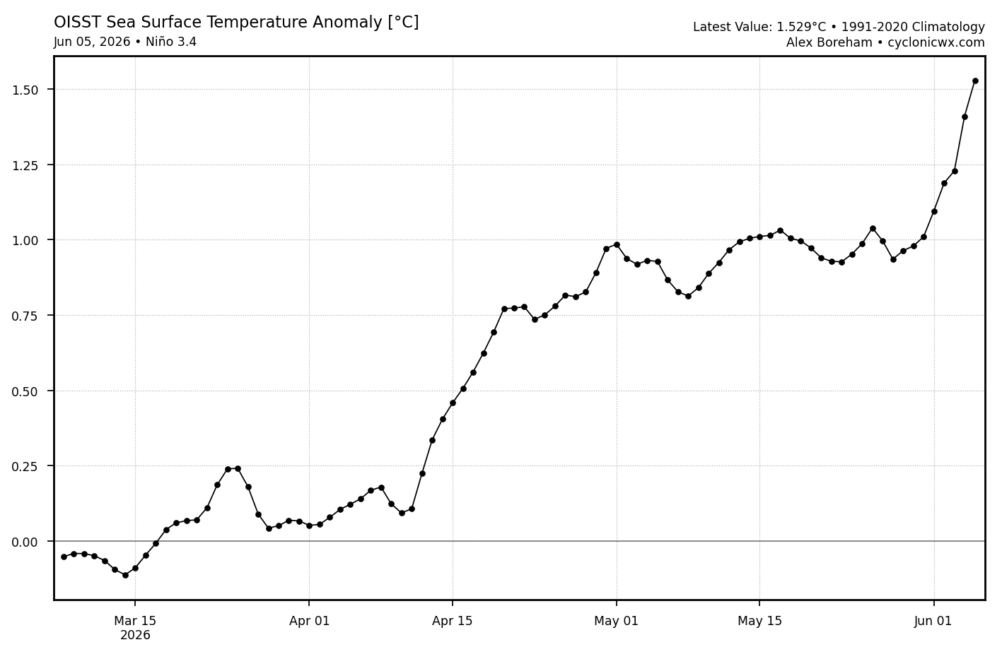
The strong 3.4 OISST warming hasn’t stopped as it warmed 0.12 on 6/5, which means a whopping 0.5C warming 5/31-6/5! Mon’s weekly should be ~0.3 warmer (~0.8). 6/5 RONI equivalent is ~+1.0:
-
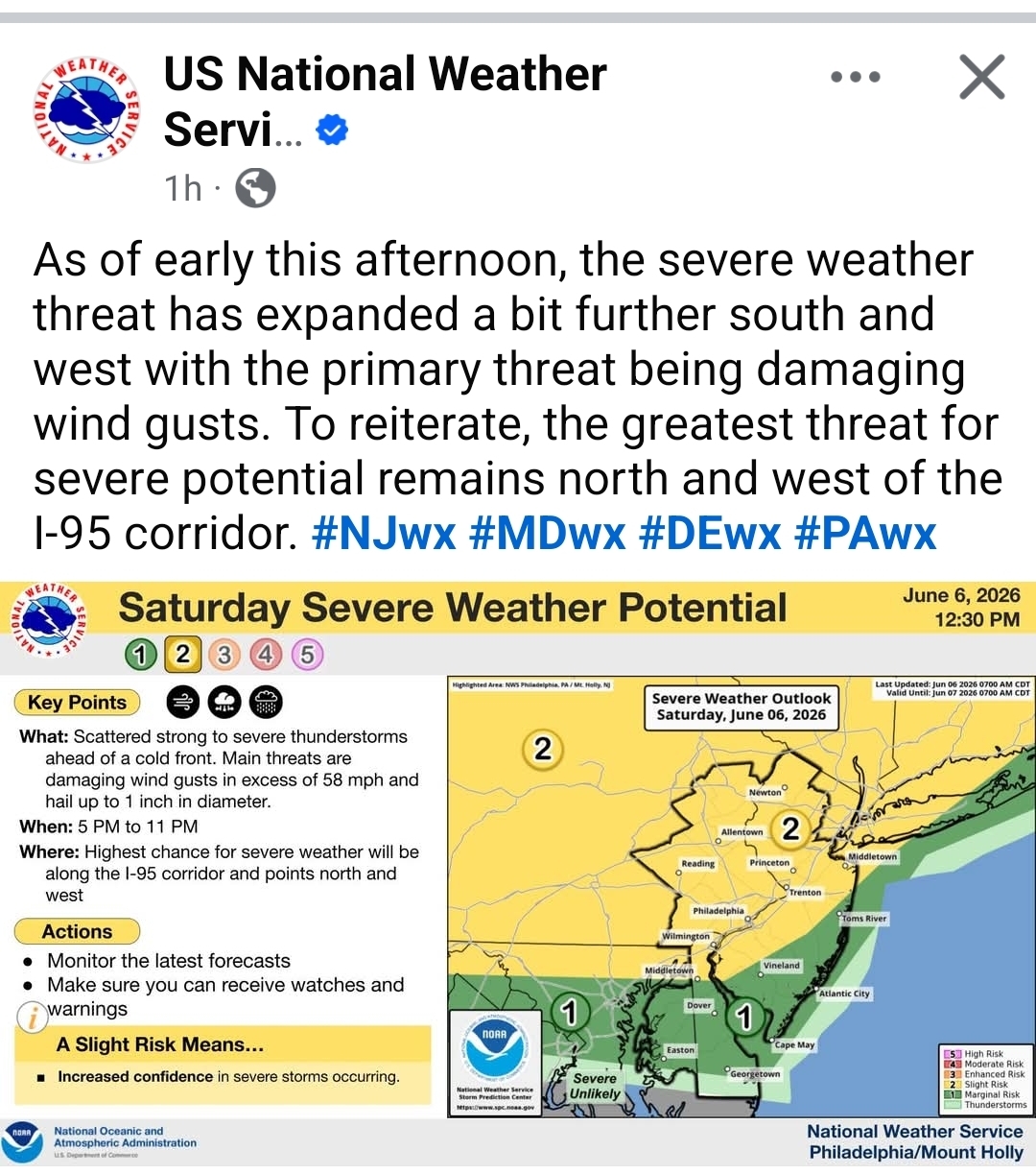
https://www.spc.noaa.gov/products/watch/ww0278.html URGENT - IMMEDIATE BROADCAST REQUESTED Severe Thunderstorm Watch Number 278 NWS Storm Prediction Center Norman OK 140 PM EDT Sat Jun 6 2026 The NWS Storm Prediction Center has issued a * Severe Thunderstorm Watch for portions of The Maryland Panhandle Central Pennsylvania Extreme northern Virginia The eastern West Virginia Panhandle * Effective this Saturday afternoon and evening from 140 PM until 800 PM EDT. * Primary threats include... Scattered damaging wind gusts to 70 mph likely Isolated large hail events to 1.5 inches in diameter possible SUMMARY...Storms are forming in western Pennsylvania, and a separate storm cluster in Ohio has a history of wind damage. Either or both areas of storms will spread into central Pennsylvania through the afternoon, and potentially as far south as the West Virginia/Maryland Panhandles. Damaging gusts will be the main threat, though the strongest storms could also produce isolated large hail (1-1.5 inches in diameter). The severe thunderstorm watch area is approximately along and 85 statute miles north and south of a line from 35 miles south southwest of Dubois PA to 40 miles northeast of Harrisburg PA. For a complete depiction of the watch see the associated watch outline update (WOUS64 KWNS WOU8). PRECAUTIONARY/PREPAREDNESS ACTIONS... REMEMBER...A Severe Thunderstorm Watch means conditions are favorable for severe thunderstorms in and close to the watch area. Persons in these areas should be on the lookout for threatening weather conditions and listen for later statements and possible warnings. Severe thunderstorms can and occasionally do produce tornadoes. &&
-
Watch up for N MD into NW VA
-
It is getting HOT in the sun.
-
Thunderstorms are like orgasms. Twenty minutes of fun and then it’s over. Haven’t had a sustained thunderstorm more than a half hour in many years. But hey, I’ll take anything including 20 minute orgasms
-
Out at the cabin in Garrett there's a thunderstorm watch just issued and I checked the radar and it looks like a pretty solid line heading this direction. 72F, sunny and windy out now.
-
72.6° for a high here Dews are up from the wetbulbing though. We take!
-
with that cold water and the storms not reaching over and past NYC until mid - late evening severe potential will be limited to gusty winds and maybe a heavier shower in coastal locations IMO especially east of NYC and coastal NJ and CT
- Today
-
If we can keep the sfc wind direction more S/SE there may be some transient supercells involved. LCL heights are really high though.
-
12 and 3 km NAM soundings show half-decent spinner potential in VT, but these models tend to overdo it a bit. Small window 4-6pm for Scott supercells in VT.
-
Satellite is encouraging.v Just made it to the Bennington welcome center
-

Junorch obs and discussion 2026
Damage In Tolland replied to Damage In Tolland's topic in New England
It’s the 2nd round of 4 annual applications. You do one in Napril, one Early Juneorch, one straight fert in Augdewst and then Winterizer in late Octorcher . Each application does different things . Fert is not a one and done lol


.thumb.gif.f92b16c631a1d15d405ed77b33f0710d.gif)